
$1,495 - $1,895
Total Monthly Price
12 Month Lease
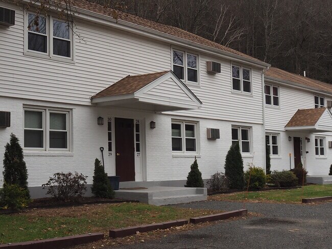
392 Montague Rd
Sunderland, MA 01375
Favorites
413-288-4713
-
Bedrooms
1 - 2
-
Bathrooms
1
-
Square Feet
650 - 850 sq ft
-
Available
Available Now
Highlight
- Smoke Free
392 Montague Rd

Favorites
2 Available Units
apt 21
$1,495
Total Monthly Price
1 bed,
1 bath,
650 sq ft
12 Month Lease, $1,495 deposit,
Available Now
15
$1,895
Total Monthly Price
2 beds,
1 bath,
850 sq ft
12 Month Lease, $1,895 deposit,
Available Now
* Price shown is base rent. Excludes user-selected optional fees and variable or usage-based fees and required charges due at or prior to move-in or at move-out.
Price, availability, fees, and any applicable rent special are subject to change without notice.
* Square footage definitions vary. Displayed square footage is approximate.
About 392 Montague Rd Sunderland, MA 01375
12 Month Lease,
$1,495 deposit,
Available Now
Immediate occupancy. 1 year lease but no security deposit. Cats ok. Smoking and dogs not allowed. Onsite laundromat. Free storage unit. Close to colleges, downtowns and easy access to major highways. Great group of long-term tenants. Amherst and Northampton and Greenfield short rides. Nature and Hiking trails abound. Out of congested downtowns and surrounded by beautiful nature. End unit 1st floor with extra windows. Good credit a must. Call Anmarie for a showing/info
392 Montague Rd is an apartment community located in Franklin County and the 01375 ZIP Code. This area is served by the Sunderland School District attendance zone.
* Price shown is total price based on community-supplied monthly required fees. Excludes user-selected optional fees and variable or usage-based fees and required charges due at or prior to move-in or at move-out. Price, availability, fees, and any applicable rent special are subject to change without notice.
* Square footage definitions vary. Displayed square footage is approximate.
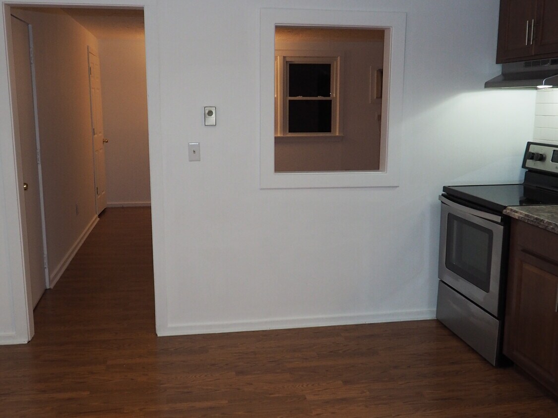
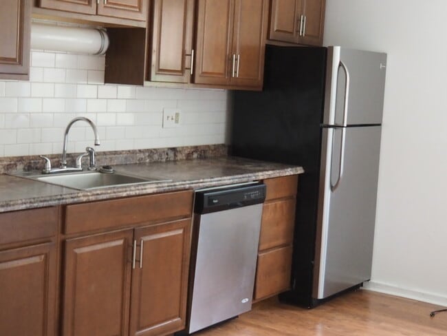
Apartment Features
- Air Conditioning
- Smoke Free
- Storage Space
- Dishwasher
- Laundry Facilities
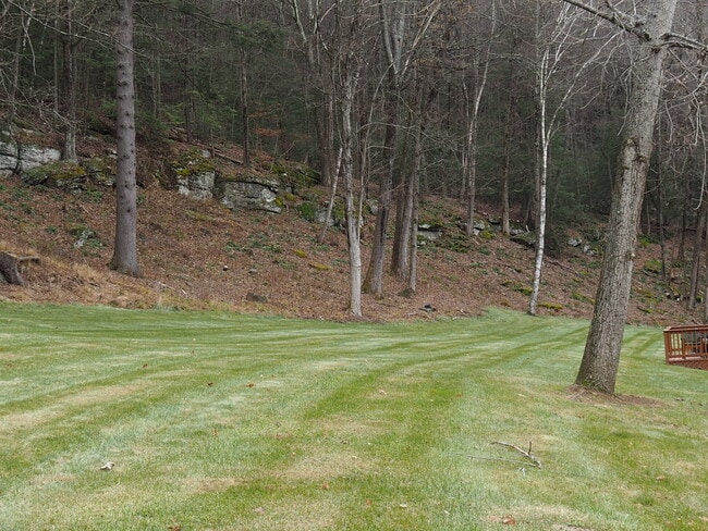
- Walking/Biking Trails
Fees and Policies
The fees listed below are community-provided and may exclude utilities or add-ons. All payments are made directly to the property and are non-refundable unless otherwise specified.
- Cats Allowed
-
Fees not specified
-
Weight limit--
-
Pet Limit--
- Parking
-
Surface Lot--
Details
Utilities Included
-
Water
-
Heat
-
Trash Removal
-
Sewer
Lease Options
-
12 Months
Property Information
-
3 units
Contact
- Listed by annmarie boulay
- Phone Number
- Contact
Location
Get Directions
On the eastern bank of the Connecticut River just nine miles north of Amherst, Sunderland is a charming town that’s stood the test of time since 1718. Sunderland’s nearly 15 square miles of land rests near a large concentration of state forests, wildlife area, and preserves, making this Massachusetts locale perfect for outdoor lovers, families, and students alike.
Sunderland is a modest town, but there are a few lively, local spots like Wild Roots and Blue Heron along Amherst Road that make a compelling case for a night out. Students might enjoy the quiet atmosphere of Sunderland, as the University of Massachusetts Amherst is only seven miles south. Take a hike through Mount Toby State Forest, or one of the many wildlife areas just north of the town. I-91 is just across the river to the west, so a trip into Springfield is never out of the question.
Learn more about living in Sunderland
Education
| Colleges & Universities | Distance | ||
|---|---|---|---|
| Colleges & Universities | Distance | ||
| Drive: | 19 min | 10.8 mi | |
| Drive: | 21 min | 11.1 mi | |
| Drive: | 28 min | 14.7 mi | |
| Drive: | 26 min | 16.4 mi |
392 Montague Rd is within 19 minutes or 10.8 miles from UMass Amherst. It is also near Amherst College and Hampshire College.
Schools


Public Elementary School
Grades PK-5
173 Students
Attendance Zone
Public Middle & High School
Grades 6-12
594 Students
Attendance Zone
Private Elementary & Middle School
Grades PK-8
128 Students
Nearby
Private Elementary & Middle School
Grades K-8
196 Students
Nearby
Private Middle School
Grades 6-8
Nearby
Private High School
Grades 9-12
633 Students
Nearby
School data provided by
 The GreatSchools Rating helps parents compare schools within a state based on a variety of school quality indicators and provides a helpful picture of how effectively each school serves all of its students. Ratings are on a scale of 1 (below average) to 10 (above average) and can include test scores, college readiness, academic progress, advanced courses, equity, discipline and attendance data. We also advise parents to visit schools, consider other information on school performance and programs, and consider family needs as part of the school selection process.
View GreatSchools Rating Methodology
Data provided by GreatSchools.org © 2026. All rights reserved.
View GreatSchools Rating Methodology
Data provided by GreatSchools.org © 2026. All rights reserved.
Getting Around
 What do Walkability, Transit, Drivability, and Bikeability mean?
Walkability measures the walking distance to day-to-day needs.
Transit measures access to public transportation.
Drivability measures congestion, parking availability, and access to major roads.
Bikeability measures the suitability for cycling.
How It Works
What do Walkability, Transit, Drivability, and Bikeability mean?
Walkability measures the walking distance to day-to-day needs.
Transit measures access to public transportation.
Drivability measures congestion, parking availability, and access to major roads.
Bikeability measures the suitability for cycling.
How It Works
Not Walkable
Walkability
10
/ 100
Minimal Public Transit
Transit
0
/ 100
Exceptionally Drivable
Drivability
100
/ 100
Not Bikeable
Bikeability
10
/ 100
Scores provided by
-
Soundscore™
-
/ 100
Traffic
-Airport
-Businesses
-Scores provided by
HowLoud What is a Sound Score Rating? A Sound Score Rating aggregates noise caused by vehicle traffic, airplane traffic and local sources. How It Works
Amenities
- Air Conditioning
- Smoke Free
- Storage Space
- Dishwasher
- Laundry Facilities
- Walking/Biking Trails
392 Montague Rd Photos
What Are Walk Score®, Transit Score®, and Bike Score® Ratings?
Walk Score® measures the walkability of any address. Transit Score® measures access to public transit. Bike Score® measures the bikeability of any address.
What is a Sound Score Rating?
A Sound Score Rating aggregates noise caused by vehicle traffic, airplane traffic and local sources.

392 Montague Rd
Sunderland, MA 01375