


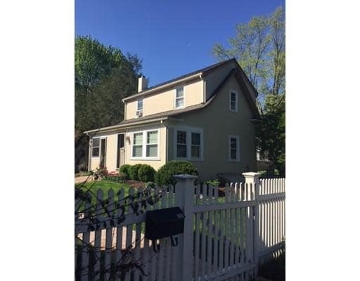
39 Twitchell St
39 Twitchell St
Wellesley, MA 02482
2 Weeks Ago
Favorites
39 Twitchell St

Favorites
Check Back Soon for Upcoming Availability
| Beds | Baths | Average SF |
|---|---|---|
| 2 Bedrooms 2 Bedrooms 2 Br | 1 Bath 1 Bath 1 Ba | 900 SF |
Fees and Policies
The fees below are based on community-supplied data and may exclude additional fees and utilities.
Pet policies are negotiable.
About This Property
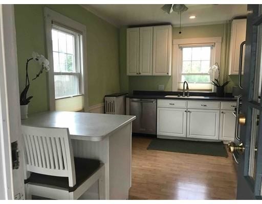
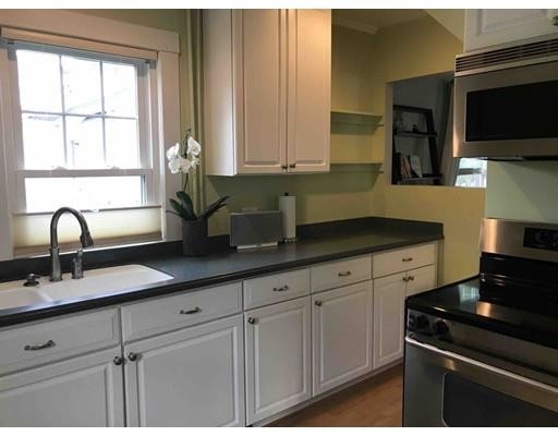
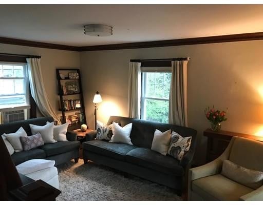
Charming carriage house located in the center of Wellesley. Close to town, train, Babson and Wellesley Colleges. "Walking distance" from WHS, WMS, Whole Foods and the Brook Path. Kitchen with corian counters, loads of cabinet space and stainless appliances. Hardwood floors throughout. High ceilings, lovely light. Shares the fenced in back yard with the main house, and has a separate designated area for your use. Parking for two cars. Plowing and lawn care included. Full basement with laundry and lots of storage.
39 Twitchell St is a house located in Norfolk County and the 02482 ZIP Code. This area is served by the Wellesley attendance zone.
House Features
Dishwasher
Microwave
Refrigerator
Disposal
- Dishwasher
- Disposal
- Microwave
- Range
- Refrigerator
- Tennis Court
- Walking/Biking Trails
- Fenced Lot
- Porch
- Garden
Location
Get Directions
Just west of Boston and East of Worcester sits Metro West, a region that houses a group of towns and cities with significant historical backgrounds. A total of 19 municipalities make up the core of this community, but other municipalities are considered to be a part of the Interstate 495/Metro West Corridor.
Learn more about living in Metro WestBelow are rent ranges for similar nearby apartments
| Beds | Average Size | Lowest | Typical | Premium |
|---|---|---|---|---|
| Studio Studio Studio | 523-525 Sq Ft | $1,400 | $2,445 | $8,378 |
| 1 Bed 1 Bed 1 Bed | 893-895 Sq Ft | $1,250 | $3,027 | $10,681 |
| 2 Beds 2 Beds 2 Beds | 1278-1280 Sq Ft | $1,900 | $3,717 | $13,408 |
| 3 Beds 3 Beds 3 Beds | 1669-1674 Sq Ft | $2,000 | $4,699 | $15,246 |
| 4 Beds 4 Beds 4 Beds | 3461 Sq Ft | $1,075 | $6,651 | $17,000 |
Amenities
- Dishwasher
- Disposal
- Microwave
- Range
- Refrigerator
- Fenced Lot
- Porch
- Garden
- Tennis Court
- Walking/Biking Trails
Education
| Colleges & Universities | Distance | ||
|---|---|---|---|
| Colleges & Universities | Distance | ||
| Drive: | 4 min | 1.4 mi | |
| Drive: | 6 min | 1.9 mi | |
| Drive: | 14 min | 6.1 mi | |
| Drive: | 16 min | 8.3 mi |
39 Twitchell St is within 4 minutes or 1.4 miles from Babson College. It is also near Wellesley College and Brandeis University.
Schools


Public Elementary School
Grades PK-5
699 Students
Nearby
Public Elementary School
Grades K-5
287 Students
Attendance Zone
Public Middle School
Grades 6-8
922 Students
Attendance Zone
Public High School
Grades 9-12
1,412 Students
Attendance Zone
Private Elementary & Middle School
Grades PK-8
185 Students
Nearby
Private Elementary, Middle & High School
Grades 3-12
161 Students
Nearby
School data provided by
 The GreatSchools Rating helps parents compare schools within a state based on a variety of school quality indicators and provides a helpful picture of how effectively each school serves all of its students. Ratings are on a scale of 1 (below average) to 10 (above average) and can include test scores, college readiness, academic progress, advanced courses, equity, discipline and attendance data. We also advise parents to visit schools, consider other information on school performance and programs, and consider family needs as part of the school selection process.
View GreatSchools Rating Methodology
Data provided by GreatSchools.org © 2025. All rights reserved.
View GreatSchools Rating Methodology
Data provided by GreatSchools.org © 2025. All rights reserved.
Transportation options available in Wellesley include Riverside, located 3.6 miles from 39 Twitchell St. 39 Twitchell St is near General Edward Lawrence Logan International, located 17.6 miles or 29 minutes away, and Worcester Regional, located 32.8 miles or 56 minutes away.
| Transit / Subway | Distance | ||
|---|---|---|---|
| Transit / Subway | Distance | ||
| Drive: | 9 min | 3.6 mi | |
| Drive: | 8 min | 3.6 mi | |
| Drive: | 9 min | 4.3 mi | |
| Drive: | 10 min | 4.9 mi | |
| Drive: | 11 min | 5.2 mi |
| Commuter Rail | Distance | ||
|---|---|---|---|
| Commuter Rail | Distance | ||
| Walk: | 20 min | 1.1 mi | |
| Drive: | 3 min | 1.2 mi | |
| Drive: | 6 min | 2.4 mi | |
| Drive: | 6 min | 3.1 mi | |
| Drive: | 7 min | 3.3 mi |
| Airports | Distance | ||
|---|---|---|---|
| Airports | Distance | ||
|
General Edward Lawrence Logan International
|
Drive: | 29 min | 17.6 mi |
|
Worcester Regional
|
Drive: | 56 min | 32.8 mi |
Time and distance from 39 Twitchell St.
| Shopping Centers | Distance | ||
|---|---|---|---|
| Shopping Centers | Distance | ||
| Walk: | 7 min | 0.4 mi | |
| Walk: | 15 min | 0.8 mi | |
| Walk: | 16 min | 0.9 mi |
39 Twitchell St has 3 shopping centers within 0.9 mile, which is about a 16-minute walk. The miles and minutes will be for the farthest away property.
| Parks and Recreation | Distance | ||
|---|---|---|---|
| Parks and Recreation | Distance | ||
|
Whitin Observatory
|
Drive: | 4 min | 1.3 mi |
|
Wellesley College Botanic Gardens
|
Drive: | 3 min | 1.6 mi |
|
Weezie's Garden for Children
|
Drive: | 9 min | 3.1 mi |
|
Elm Bank Reservation
|
Drive: | 9 min | 3.1 mi |
|
Horticultural Society at Elm Bank
|
Drive: | 10 min | 3.3 mi |
39 Twitchell St has 5 parks within 3.3 miles, including Whitin Observatory, Wellesley College Botanic Gardens, and Horticultural Society at Elm Bank.
| Hospitals | Distance | ||
|---|---|---|---|
| Hospitals | Distance | ||
| Drive: | 6 min | 3.3 mi | |
| Drive: | 7 min | 3.4 mi | |
| Drive: | 14 min | 6.6 mi |
39 Twitchell St has 3 hospitals within 6.6 miles, the nearest is Beth Israel Deaconess Hospital - Needham which is 3.3 miles away and a 6 minute drive.
| Military Bases | Distance | ||
|---|---|---|---|
| Military Bases | Distance | ||
| Drive: | 9 min | 4.5 mi | |
| Drive: | 25 min | 13.5 mi |
39 Twitchell St is 4.5 miles from US Military Reservation, and is convenient to other military bases, including Hanscom Air Force Base.
You May Also Like
Similar Rentals Nearby


What Are Walk Score®, Transit Score®, and Bike Score® Ratings?
Walk Score® measures the walkability of any address. Transit Score® measures access to public transit. Bike Score® measures the bikeability of any address.
What is a Sound Score Rating?
A Sound Score Rating aggregates noise caused by vehicle traffic, airplane traffic and local sources
39 Twitchell St
Wellesley, MA 02482