

$695
Total Monthly Price
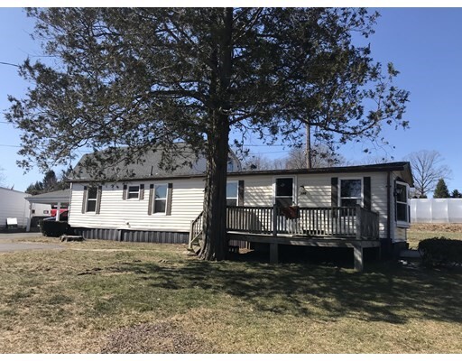
388 E Mountain Rd
Westfield, MA 01085
Favorites
388 E Mountain Rd

Favorites
Check Back Soon for Upcoming Availability
| Beds | Baths | Average SF |
|---|---|---|
| 1 Bedroom 1 Bedroom 1 Br | 1 Bath 1 Bath 1 Ba | 650 SF |
Fees and Policies
The fees listed below are community-provided and may exclude utilities or add-ons. All payments are made directly to the property and are non-refundable unless otherwise specified.
Details
Utilities Included
-
Water
-
Heat
-
Trash Removal
-
Sewer
About This Property
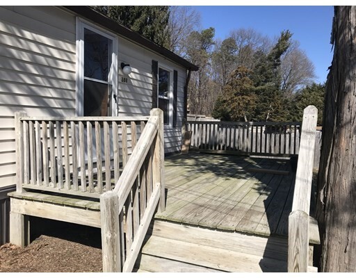
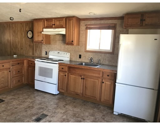
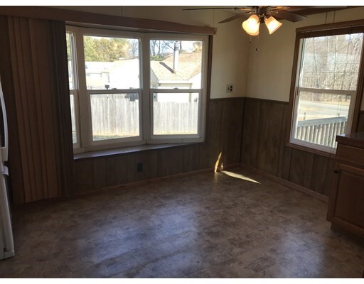
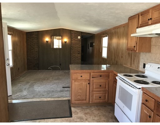
Cute, small mobile home for rent situated on a working farm. Perfect for one or two people at most. Large deck on the front. Stove and refrigerator included in kitchen which is open to the family room. Heat included in the rent. Tenant pays electricity. Washer and dryer hook-ups in unit. Credit check fee is non-refundable $25.00 for each adult. NO Pets. NO Smoking.
388 E Mountain Rd is a house located in Hampden County and the 01085 ZIP Code. This area is served by the Westfield School District attendance zone.
House Features
Refrigerator
Disposal
Range
Cable Ready
- Cable Ready
- Disposal
- Range
- Refrigerator
- Walking/Biking Trails
- Deck
388 E Mountain Rd,
Westfield,
MA
01085
Situated in the Pioneer Valley of Western Massachusetts, Westfield exudes a rural charm on the cusp of several larger communities. Recreational opportunities abound in Westfield, with access to Stanley Park, Hampton Ponds State Park, the Westfield River, the Little River, Amelia Park Arena and Garden, and multiple country clubs. Westfield is also nearby Robinson State Park, Forest Park, and the Connecticut River in addition to Six Flags New England, which provide many additional options for outdoor fun.
Westfield offers plenty of local shops and eateries to peruse in the downtown district, and the national retailers in Holyoke Mall are just a short drive away too. Westfield is home to Westfield State University, which presents a host of cultural and educational opportunities to the local community. Commuting and traveling from Westfield is easy with convenience to I-90, Westfield Barnes Regional Airport, and Bradley International Airport.
Learn more about living in Westfield
Amenities
- Cable Ready
- Disposal
- Range
- Refrigerator
- Deck
- Walking/Biking Trails
Expenses
Utilities Included
Water, Heat, Trash Removal, Sewer
Included
Education
| Colleges & Universities | Distance | ||
|---|---|---|---|
| Colleges & Universities | Distance | ||
| Drive: | 11 min | 6.2 mi | |
| Drive: | 15 min | 7.0 mi | |
| Drive: | 19 min | 9.9 mi | |
| Drive: | 22 min | 10.9 mi |
388 E Mountain Rd is within 11 minutes or 6.2 miles from Westfield State University. It is also near Holyoke Community College and American International College.
Schools


Public Elementary School
Grades PK-5
599 Students
Nearby
Public Elementary School
Grades K-5
326 Students
Nearby
Public Middle School
Grades 6-8
686 Students
Nearby
Public High School
Grades 9-12
1,008 Students
Attendance Zone
Private Elementary & Middle School
Grades PK-8
241 Students
Nearby
Private High School
Grades 9-12
332 Students
Nearby
School data provided by
 The GreatSchools Rating helps parents compare schools within a state based on a variety of school quality indicators and provides a helpful picture of how effectively each school serves all of its students. Ratings are on a scale of 1 (below average) to 10 (above average) and can include test scores, college readiness, academic progress, advanced courses, equity, discipline and attendance data. We also advise parents to visit schools, consider other information on school performance and programs, and consider family needs as part of the school selection process.
View GreatSchools Rating Methodology
Data provided by GreatSchools.org © 2026. All rights reserved.
View GreatSchools Rating Methodology
Data provided by GreatSchools.org © 2026. All rights reserved.
Walkability Near 388 E Mountain Rd Westfield, MA 01085
Getting Around
 What do Walkability, Transit, Drivability, and Bikeability mean?
Walkability measures the walking distance to day-to-day needs.
Transit measures access to public transportation.
Drivability measures congestion, parking availability, and access to major roads.
Bikeability measures the suitability for cycling.
How It Works
What do Walkability, Transit, Drivability, and Bikeability mean?
Walkability measures the walking distance to day-to-day needs.
Transit measures access to public transportation.
Drivability measures congestion, parking availability, and access to major roads.
Bikeability measures the suitability for cycling.
How It Works
Somewhat Walkable
Walkability
20
/ 100
Minimal Public Transit
Transit
0
/ 100
Exceptionally Drivable
Drivability
100
/ 100
Fairly Bikeable
Bikeability
40
/ 100
Scores provided by
-
Soundscore™
-
/ 100
Traffic
-Airport
-Businesses
-Scores provided by
HowLoud What is a Sound Score Rating? A Sound Score Rating aggregates noise caused by vehicle traffic, airplane traffic and local sources. How It WorksYou May Also Like
Similar Rentals Nearby
-
-

-

-

-

-

-

-

-
 2 Beds, 1 Bath, 1,523 sq ft$1,800Total Monthly PriceTotal Monthly Price NewPrices include all required monthly fees.103 Capen St
 -
 2 Beds, 2 Baths, 1,286 sq ft$2,300Total Monthly PriceTotal Monthly Price NewPrices include all required monthly fees.138 Mountain St
What Are Walk Score®, Transit Score®, and Bike Score® Ratings?
Walk Score® measures the walkability of any address. Transit Score® measures access to public transit. Bike Score® measures the bikeability of any address.
What is a Sound Score Rating?
A Sound Score Rating aggregates noise caused by vehicle traffic, airplane traffic and local sources.
388 E Mountain Rd
Westfield, MA 01085