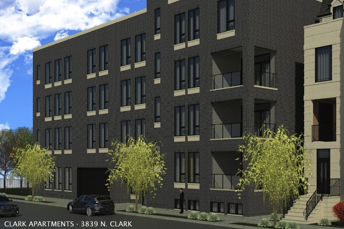
Clark Apartments
3839 N Clark St,
Chicago,
IL
60613
-
Monthly Rent
$2,500 - $6,400
-
Bedrooms
1 - 3 bd
-
Bathrooms
1 - 2.5 ba
-
Square Feet
850 - 2,000 sq ft
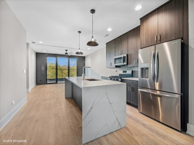
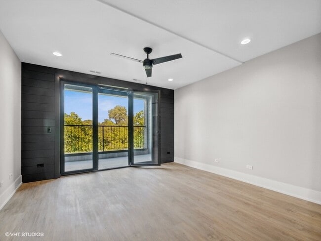
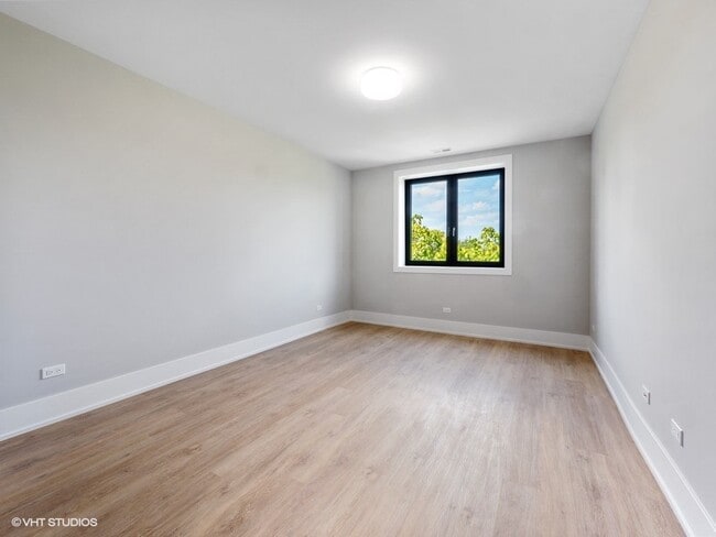
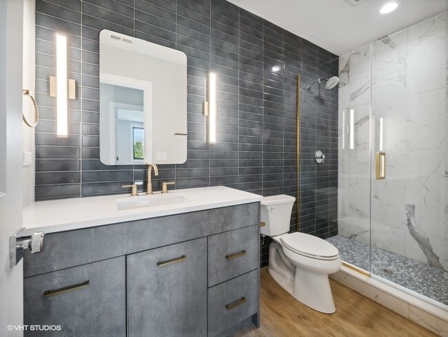
Brand New luxury rentals in the heart of Lakeview/Wrigley. Condo-quality units with transitional finishes throughout with a mix of units from 1, 2, and 3-bedroom options. Features large kitchens with stainless steel appliances, quartz countertops with waterfall edges, washer/dryer in unit, master bedroom with attached bath, walk-in showers, Nest thermostats, and private outdoor decks. Building amenities include an elevator, soundproof windows, bike storage, and attached heated garage parking on the ground floor and outdoor parking available. Close to Wrigley, Southport shops, restaurants, schools, and public transportation. Walk Score of 91 and convenient to Red Line Station. Blaine School District
Highlights
- New Construction
- Walker's Paradise
- Walk-In Closets
- Deck
- Island Kitchen
- Elevator
- Balcony
Pricing & Floor Plans
-
Unit 204price $2,800square feet 850availibility Mar 15
-
Unit 205price $3,500square feet 1,170availibility Mar 15
-
Unit 401price $4,600square feet 1,700availibility Mar 1
-
Unit 105price $5,800square feet 2,000availibility Mar 15
-
Unit 104price $5,800square feet 2,000availibility Mar 15
-
Unit 304price $6,400square feet 2,000availibility Mar 15
-
Unit 204price $2,800square feet 850availibility Mar 15
-
Unit 205price $3,500square feet 1,170availibility Mar 15
-
Unit 401price $4,600square feet 1,700availibility Mar 1
-
Unit 105price $5,800square feet 2,000availibility Mar 15
-
Unit 104price $5,800square feet 2,000availibility Mar 15
-
Unit 304price $6,400square feet 2,000availibility Mar 15
Fees and Policies
The fees below are based on community-supplied data and may exclude additional fees and utilities.
-
One-Time Basics
-
Administrative Fee$250
-
Application Fee Per Applicant$65
-
-
Garage Lot
Property Fee Disclaimer: Based on community-supplied data and independent market research. Subject to change without notice. May exclude fees for mandatory or optional services and usage-based utilities.
Details
Utilities Included
-
Water
-
Trash Removal
-
Sewer
Lease Options
-
12 - 24 Month Leases
Property Information
-
Built in 2026
-
15 units/4 stories
About Clark Apartments
Brand New luxury rentals in the heart of Lakeview/Wrigley. Condo-quality units with transitional finishes throughout with a mix of units from 1, 2, and 3-bedroom options. Features large kitchens with stainless steel appliances, quartz countertops with waterfall edges, washer/dryer in unit, master bedroom with attached bath, walk-in showers, Nest thermostats, and private outdoor decks. Building amenities include an elevator, soundproof windows, bike storage, and attached heated garage parking on the ground floor and outdoor parking available. Close to Wrigley, Southport shops, restaurants, schools, and public transportation. Walk Score of 91 and convenient to Red Line Station. Blaine School District
Clark Apartments is an apartment community located in Cook County and the 60613 ZIP Code. This area is served by the Chicago Public Schools attendance zone.
Contact
Community Amenities
- Elevator
- Bicycle Storage
Apartment Features
Washer/Dryer
Air Conditioning
Dishwasher
Walk-In Closets
Island Kitchen
Microwave
Refrigerator
Disposal
Indoor Features
- Washer/Dryer
- Air Conditioning
- Heating
- Ceiling Fans
- Smoke Free
- Double Vanities
- Intercom
- Sprinkler System
- Framed Mirrors
Kitchen Features & Appliances
- Dishwasher
- Disposal
- Ice Maker
- Stainless Steel Appliances
- Pantry
- Island Kitchen
- Kitchen
- Microwave
- Refrigerator
- Freezer
- Quartz Countertops
- Gas Range
Model Details
- Walk-In Closets
- Linen Closet
- Balcony
- Deck
- Elevator
- Bicycle Storage
- Washer/Dryer
- Air Conditioning
- Heating
- Ceiling Fans
- Smoke Free
- Double Vanities
- Intercom
- Sprinkler System
- Framed Mirrors
- Dishwasher
- Disposal
- Ice Maker
- Stainless Steel Appliances
- Pantry
- Island Kitchen
- Kitchen
- Microwave
- Refrigerator
- Freezer
- Quartz Countertops
- Gas Range
- Walk-In Closets
- Linen Closet
- Balcony
- Deck
| Monday | 9am - 5pm |
|---|---|
| Tuesday | 9am - 5pm |
| Wednesday | 9am - 5pm |
| Thursday | 9am - 5pm |
| Friday | 9am - 5pm |
| Saturday | Closed |
| Sunday | Closed |
If you love baseball — particularly if you love the Chicago Cubs — there's only one neighborhood for you: Lakeview! Bordering Lake Michigan on the north side of Chicago directly above Lincoln Park, Lakeview houses one of Chicago’s most popular destinations: Wrigley Field. Originally built in 1914 for Federal League’s Chicago Whales, Wrigley Field is one the oldest still-operating stadiums in the MLB. It was renamed Wrigley Field in 1926 by then-owner William Wrigley Jr., a chewing gum manufacturer.
Of course, there's more to Lakeview than baseball. From the luxury high-rise apartments along Lake Shore Drive to the tree-filled streets and single-family homes in Graceland West, there's something for everyone in Lakeview. This large neighborhood consists of several smaller enclaves, including Wrigleyville, Boystown, and North Halsted. Lakeview features several theaters, such as the Music Box Theater and the Playground Theater, as well as music venues and shops.
Learn more about living in LakeviewCompare neighborhood and city base rent averages by bedroom.
| Lakeview | Chicago, IL | |
|---|---|---|
| Studio | $904 | $1,594 |
| 1 Bedroom | $1,532 | $1,967 |
| 2 Bedrooms | $1,808 | $2,483 |
| 3 Bedrooms | $2,196 | $3,019 |
| Colleges & Universities | Distance | ||
|---|---|---|---|
| Colleges & Universities | Distance | ||
| Drive: | 3 min | 1.5 mi | |
| Drive: | 5 min | 2.4 mi | |
| Drive: | 5 min | 2.7 mi | |
| Drive: | 7 min | 3.8 mi |


View GreatSchools Rating Methodology
Data provided by GreatSchools.org © 2026. All rights reserved.
Transportation options available in Chicago include Sheridan Station, located 0.5 mile from Clark Apartments. Clark Apartments is near Chicago O'Hare International, located 13.8 miles or 22 minutes away, and Chicago Midway International, located 14.7 miles or 27 minutes away.
| Transit / Subway | Distance | ||
|---|---|---|---|
| Transit / Subway | Distance | ||
|
|
Walk: | 10 min | 0.5 mi |
|
|
Walk: | 10 min | 0.5 mi |
|
|
Walk: | 15 min | 0.8 mi |
|
|
Walk: | 16 min | 0.8 mi |
|
|
Drive: | 3 min | 1.4 mi |
| Commuter Rail | Distance | ||
|---|---|---|---|
| Commuter Rail | Distance | ||
|
|
Drive: | 3 min | 1.6 mi |
| Drive: | 5 min | 3.1 mi | |
|
|
Drive: | 6 min | 3.1 mi |
|
|
Drive: | 6 min | 3.9 mi |
|
|
Drive: | 10 min | 5.7 mi |
| Airports | Distance | ||
|---|---|---|---|
| Airports | Distance | ||
|
Chicago O'Hare International
|
Drive: | 22 min | 13.8 mi |
|
Chicago Midway International
|
Drive: | 27 min | 14.7 mi |
Time and distance from Clark Apartments.
| Shopping Centers | Distance | ||
|---|---|---|---|
| Shopping Centers | Distance | ||
| Walk: | 11 min | 0.6 mi | |
| Walk: | 16 min | 0.8 mi | |
| Drive: | 2 min | 1.1 mi |
| Parks and Recreation | Distance | ||
|---|---|---|---|
| Parks and Recreation | Distance | ||
|
Chase Park
|
Drive: | 2 min | 1.3 mi |
|
Wrightwood Park
|
Drive: | 5 min | 2.2 mi |
|
Winnemac Park
|
Drive: | 5 min | 2.5 mi |
|
Notebaert Nature Museum
|
Drive: | 5 min | 2.5 mi |
|
Oz Park
|
Drive: | 5 min | 2.6 mi |
| Hospitals | Distance | ||
|---|---|---|---|
| Hospitals | Distance | ||
| Walk: | 14 min | 0.8 mi | |
| Drive: | 3 min | 1.4 mi | |
| Drive: | 3 min | 1.8 mi |
| Military Bases | Distance | ||
|---|---|---|---|
| Military Bases | Distance | ||
| Drive: | 30 min | 21.4 mi |
Clark Apartments Photos
-
Clark Apartments
-
-
-
-
-
-
-
-
Models
-
Ground Floor - Heated Garage
-
Unit 104
-
Unit 105
-
Unit 204
-
Unit 205
-
Unit 304
Nearby Apartments
Within 50 Miles of Clark Apartments
Clark Apartments has units with in‑unit washers and dryers, making laundry day simple for residents.
Select utilities are included in rent at Clark Apartments, including water, trash removal, and sewer. Residents are responsible for any other utilities not listed.
Parking is available at Clark Apartments. Contact this property for details.
Clark Apartments has one to three-bedrooms with rent ranges from $2,500/mo. to $6,400/mo.
Clark Apartments does not allow pets, though service animals are always welcome in accordance with applicable laws.
A good rule of thumb is to spend no more than 30% of your gross income on rent. Based on the lowest available rent of $2,500 for a one-bedroom, you would need to earn about $90,000 per year to qualify. Want to double-check your budget? Try our Rent Affordability Calculator to see how much rent fits your income and lifestyle.
Clark Apartments is not currently offering any rent specials. Check back soon, as promotions change frequently.
While Clark Apartments does not offer Matterport 3D tours, renters can request a tour directly through our online platform.
What Are Walk Score®, Transit Score®, and Bike Score® Ratings?
Walk Score® measures the walkability of any address. Transit Score® measures access to public transit. Bike Score® measures the bikeability of any address.
What is a Sound Score Rating?
A Sound Score Rating aggregates noise caused by vehicle traffic, airplane traffic and local sources

3839 N Clark St
Chicago, IL 60613
Property Manager Responded