
-
Country Living
$1,595
/ Month
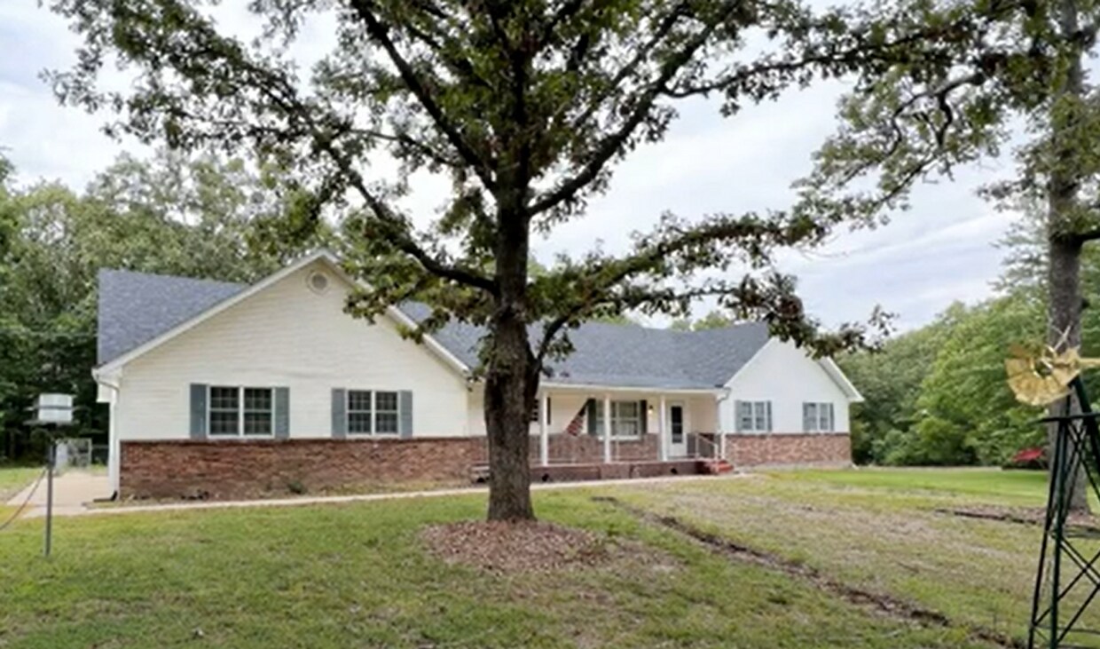
383 Hwy Oo
Rolla, MO 65401
Favorites
-
Bedrooms
3
-
Bathrooms
2
-
Square Feet
--
383 Hwy Oo

Favorites
About This Home
1st Month Rent $2295.00 Washer/Dryer 3 Car Garage
383 Hwy Oo is a house located in Dent County and the 65401 ZIP Code. This area is served by the Dent-Phelps R-Iii School District attendance zone.
* Price shown is base rent. Excludes user-selected optional fees and variable or usage-based fees and required charges due at or prior to move-in or at move-out. Price, availability, fees, and any applicable rent special are subject to change without notice.
* Square footage definitions vary. Displayed square footage is approximate.
House Features
- Dishwasher
Contact
- Listed by Investment Realty, Inc. | Investment Realty, Inc.
Location
Get Directions
Rolla is a small city in central Missouri, located roughly halfway between Saint Louis and Springfield along Interstate 44. The city is perhaps best known as the home of Missouri University of Science and Technology, which serves around 9,000 students from around the world and operates as one of the community’s biggest employers. The Downtown district along Pine Street is just a short walk from campus, providing a diverse mix of shopping, dining, and nightlife catering to the college crowd and locals alike.
The landscape surrounding Rolla is ideal for outdoor exploration, with Fort Leonard Wood and Mark Twain National Forest sitting just outside the city limits and sprawling greenspaces like Southview and Ber Juan Parks just a few blocks away from most neighborhoods.
Learn more about living in Rolla
Amenities
- Dishwasher
Education
| Colleges & Universities | Distance | ||
|---|---|---|---|
| Colleges & Universities | Distance | ||
| Drive: | 39 min | 16.4 mi |
383 Hwy Oo is within 39 minutes or 16.4 miles from Missouri Univ. of Sci. &Tech..
Schools


Public Elementary & Middle School
Grades PK-8
273 Students
Attendance Zone
Public High School
Grades 9-12
616 Students
Nearby
Private Elementary, Middle & High School
Grades PK-12
255 Students
Nearby
Private Elementary & Middle School
Grades PK-8
59 Students
Nearby
Private Elementary & Middle School
Grades K-8
6 Students
Nearby
School data provided by
 The GreatSchools Rating helps parents compare schools within a state based on a variety of school quality indicators and provides a helpful picture of how effectively each school serves all of its students. Ratings are on a scale of 1 (below average) to 10 (above average) and can include test scores, college readiness, academic progress, advanced courses, equity, discipline and attendance data. We also advise parents to visit schools, consider other information on school performance and programs, and consider family needs as part of the school selection process.
View GreatSchools Rating Methodology
Data provided by GreatSchools.org © 2026. All rights reserved.
View GreatSchools Rating Methodology
Data provided by GreatSchools.org © 2026. All rights reserved.
Getting Around
 What do Walkability, Transit, Drivability, and Bikeability mean?
Walkability measures the walking distance to day-to-day needs.
Transit measures access to public transportation.
Drivability measures congestion, parking availability, and access to major roads.
Bikeability measures the suitability for cycling.
How It Works
What do Walkability, Transit, Drivability, and Bikeability mean?
Walkability measures the walking distance to day-to-day needs.
Transit measures access to public transportation.
Drivability measures congestion, parking availability, and access to major roads.
Bikeability measures the suitability for cycling.
How It Works
Not Walkable
Walkability
0
/ 100
Exceptionally Drivable
Drivability
100
/ 100
Somewhat Bikeable
Bikeability
20
/ 100
Scores provided by
-
Soundscore™
-
/ 100
Traffic
-Airport
-Businesses
-Scores provided by
HowLoud What is a Sound Score Rating? A Sound Score Rating aggregates noise caused by vehicle traffic, airplane traffic and local sources. How It WorksSimilar Rentals Nearby


What Are Walk Score®, Transit Score®, and Bike Score® Ratings?
Walk Score® measures the walkability of any address. Transit Score® measures access to public transit. Bike Score® measures the bikeability of any address.
What is a Sound Score Rating?
A Sound Score Rating aggregates noise caused by vehicle traffic, airplane traffic and local sources.
383 Hwy Oo
Rolla, MO 65401