


$4,900 / Month
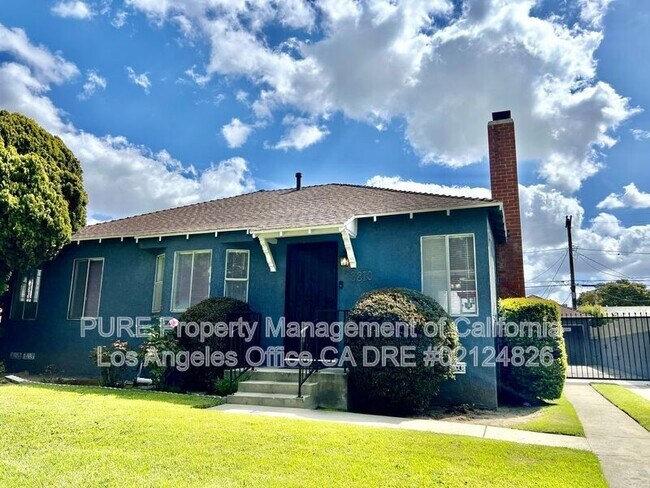
3810 S Muirfield Rd
Los Angeles, CA 90008
2 Weeks Ago
Favorites
3810 S Muirfield Rd

Favorites
Check Back Soon for Upcoming Availability
| Beds | Baths | Average SF |
|---|---|---|
| 3 Bedrooms 3 Bedrooms 3 Br | 3 Baths 3 Baths 3 Ba | 2,500 SF |
About This Property
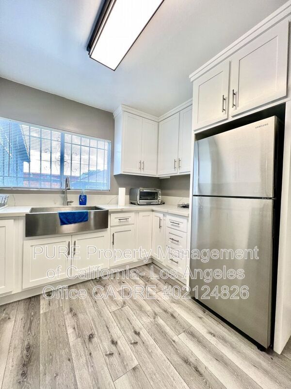
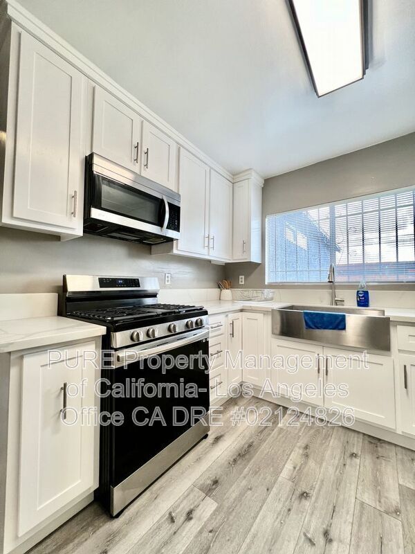
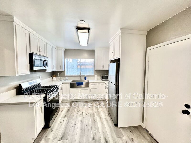
- Rent: $4,900 Per Month - Deposit: $5,000 - Bedrooms: 3 - Bathrooms: 3 - Approx 2,500 Sq.Ft. Features: - Updated Singe Family Home - Furniture can be included - Spacious Living room & Den - Gas Fireplace - Washer & Dryer Included (Not Warranted) - Plenty of storage throughout - Updated Kitchen with Stainless Appliances - Fridge Included (Not Warranted) - Window blinds throughout - Central Heat - Large Back Yard - 2 Car Driveway Parking (Garage is not included) - No Utilities Included - No Pets
3810 S Muirfield Rd is a house located in Los Angeles County and the 90008 ZIP Code. This area is served by the Los Angeles Unified attendance zone.
Location
Get Directions
Crenshaw is a diverse neighborhood located in South Los Angeles, California. Crenshaw, which is rooted in African American history, is home to the famous Hyde Park neighborhood that’s often referred to as “the heart of African American commerce in Los Angeles.” Famous rapper Nipsey Hussle paid tribute to Crenshaw Boulevard in his songs.
The neighborhood has great access to the LAX metro system with lines running to the Los Angeles International Airport.
Crenshaw provides quick access to I-105 and I-10, making it simple to access Downtown Los Angeles. The Kenneth Hahn State Recreation area, located nearby, features a workout course, Japanese gardens, athletic fields, disc golf, and walking/running trails. Every year, the neighborhood hosts “Destination Crenshaw,” a 1.3-mile-long outdoor art and culture exhibit featuring Black Los Angeles. When you rent your apartment in Crenshaw, you‘ll enjoy a neighborhood rich with African American history where culture is celebrated.
Learn more about living in CrenshawBelow are rent ranges for similar nearby apartments
| Beds | Average Size | Lowest | Typical | Premium |
|---|---|---|---|---|
| Studio Studio Studio | 485 Sq Ft | $812 | $1,789 | $2,166 |
| 1 Bed 1 Bed 1 Bed | 773-775 Sq Ft | $780 | $2,127 | $3,300 |
| 2 Beds 2 Beds 2 Beds | 1066-1072 Sq Ft | $929 | $2,679 | $4,500 |
| 3 Beds 3 Beds 3 Beds | 1410-1412 Sq Ft | $2,400 | $4,281 | $8,500 |
| 4 Beds 4 Beds 4 Beds | 1598 Sq Ft | $4,100 | $4,667 | $7,500 |
Education
| Colleges & Universities | Distance | ||
|---|---|---|---|
| Colleges & Universities | Distance | ||
| Drive: | 8 min | 4.0 mi | |
| Drive: | 10 min | 4.1 mi | |
| Drive: | 9 min | 5.2 mi | |
| Drive: | 10 min | 5.8 mi |
3810 S Muirfield Rd is within 8 minutes or 4.0 miles from USC, University Park Campus. It is also near West Los Angeles College and Mount St. Mary's Coll, Doheny.
Schools


Public Elementary School
Grades K-5
542 Students
Nearby
Public Elementary School
Grades K-5
188 Students
Attendance Zone
Public Middle School
Grades 6-8
407 Students
Attendance Zone
Public High School
Grades 9-12
802 Students
Attendance Zone
Private Elementary School
Grades PK-5
Nearby
Private Elementary, Middle & High School
Grades K-11
Nearby
Private Elementary & Middle School
Grades K-8
Nearby
Private Middle & High School
Grades 7-12
Nearby
School data provided by
 The GreatSchools Rating helps parents compare schools within a state based on a variety of school quality indicators and provides a helpful picture of how effectively each school serves all of its students. Ratings are on a scale of 1 (below average) to 10 (above average) and can include test scores, college readiness, academic progress, advanced courses, equity, discipline and attendance data. We also advise parents to visit schools, consider other information on school performance and programs, and consider family needs as part of the school selection process.
View GreatSchools Rating Methodology
Data provided by GreatSchools.org © 2025. All rights reserved.
View GreatSchools Rating Methodology
Data provided by GreatSchools.org © 2025. All rights reserved.
Transportation options available in Los Angeles include Farmdale, located 0.7 mile from 3810 S Muirfield Rd. 3810 S Muirfield Rd is near Los Angeles International, located 8.7 miles or 16 minutes away, and Bob Hope, located 16.2 miles or 28 minutes away.
| Transit / Subway | Distance | ||
|---|---|---|---|
| Transit / Subway | Distance | ||
|
|
Walk: | 12 min | 0.7 mi |
|
|
Walk: | 15 min | 0.8 mi |
| Walk: | 16 min | 0.8 mi | |
|
|
Drive: | 3 min | 1.3 mi |
| Drive: | 2 min | 1.3 mi |
| Commuter Rail | Distance | ||
|---|---|---|---|
| Commuter Rail | Distance | ||
|
|
Drive: | 14 min | 8.4 mi |
|
|
Drive: | 16 min | 8.5 mi |
|
|
Drive: | 20 min | 11.3 mi |
| Drive: | 18 min | 12.4 mi | |
|
|
Drive: | 25 min | 15.0 mi |
| Airports | Distance | ||
|---|---|---|---|
| Airports | Distance | ||
|
Los Angeles International
|
Drive: | 16 min | 8.7 mi |
|
Bob Hope
|
Drive: | 28 min | 16.2 mi |
Time and distance from 3810 S Muirfield Rd.
| Shopping Centers | Distance | ||
|---|---|---|---|
| Shopping Centers | Distance | ||
| Walk: | 5 min | 0.3 mi | |
| Walk: | 11 min | 0.6 mi | |
| Walk: | 12 min | 0.6 mi |
3810 S Muirfield Rd has 3 shopping centers within 0.6 mile, which is about a 12-minute walk. The miles and minutes will be for the farthest away property.
| Parks and Recreation | Distance | ||
|---|---|---|---|
| Parks and Recreation | Distance | ||
|
Kenneth Hahn State Recreation Area
|
Drive: | 7 min | 2.2 mi |
|
Natural History Museum of LA County
|
Drive: | 7 min | 3.2 mi |
|
Exposition Park Rose Garden
|
Drive: | 7 min | 3.3 mi |
|
California Science Center
|
Drive: | 9 min | 4.2 mi |
|
La Brea Tar Pits
|
Drive: | 9 min | 4.9 mi |
3810 S Muirfield Rd has 5 parks within 4.9 miles, including Kenneth Hahn State Recreation Area, Natural History Museum of LA County, and Exposition Park Rose Garden.
| Hospitals | Distance | ||
|---|---|---|---|
| Hospitals | Distance | ||
| Drive: | 7 min | 3.7 mi | |
| Drive: | 8 min | 4.6 mi | |
| Drive: | 9 min | 4.8 mi |
3810 S Muirfield Rd has 3 hospitals within 4.8 miles, the nearest is Kaiser Foundation Hospital - West LA which is 3.7 miles away and a 7 minute drive.
| Military Bases | Distance | ||
|---|---|---|---|
| Military Bases | Distance | ||
| Drive: | 16 min | 10.3 mi |
3810 S Muirfield Rd is 10.3 miles and a 16 minute drive from Los Angeles Air Force Base.
You May Also Like
Similar Rentals Nearby


What Are Walk Score®, Transit Score®, and Bike Score® Ratings?
Walk Score® measures the walkability of any address. Transit Score® measures access to public transit. Bike Score® measures the bikeability of any address.
What is a Sound Score Rating?
A Sound Score Rating aggregates noise caused by vehicle traffic, airplane traffic and local sources
3810 S Muirfield Rd
Los Angeles, CA 90008