
Venue Residences
3688 Overland Ave,
Los Angeles, CA 90034
$2,695 - $5,995
Studio - 2 Beds
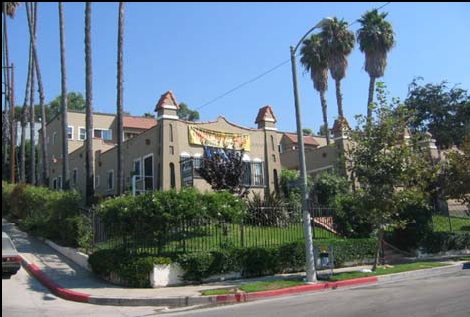

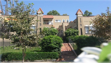
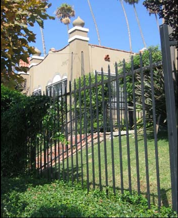
Experience Los Angeles living at 3805-3811 Montclair St. The 90018 location in Los Angeles is an ideal place to live. Be sure to come for a visit to see the current floorplan options. The professional leasing staff is ready and waiting for you to visit. Come see 3805-3811 Montclair St today.
3805-3811 Montclair St is an apartment community located in Los Angeles County and the 90018 ZIP Code. This area is served by the Los Angeles Unified Rocp School District attendance zone.
High Speed Internet Access
Smoke Free
Heating
Kitchen
Located in the western part of Los Angeles, West Adams is home to a variety of popular attractions and places. West Adams residents enjoy being less than 10 miles from Downtown Los Angeles, making the neighborhood a short drive from places like the Los Angeles Convention Center, Staples Center, and the Los Angeles County Museum of Art. In addition, the community is close to the University of Southern California and Los Angeles Trade Technical College. The neighborhood itself features a number of small businesses, restaurants, bars, and shops as well as a few small parks for residents to enjoy. Those looking to rent in West Adams will find a variety of rental choices throughout the neighborhood’s well-populated streets.
Learn more about living in West AdamsCompare neighborhood and city base rent averages by bedroom.
| West Adams | Los Angeles, CA | |
|---|---|---|
| Studio | $1,005 | $1,708 |
| 1 Bedroom | $1,162 | $2,181 |
| 2 Bedrooms | $1,391 | $3,008 |
| 3 Bedrooms | $1,951 | $4,290 |
| Colleges & Universities | Distance | ||
|---|---|---|---|
| Colleges & Universities | Distance | ||
| Drive: | 6 min | 2.8 mi | |
| Drive: | 7 min | 3.7 mi | |
| Drive: | 8 min | 4.2 mi | |
| Drive: | 8 min | 4.5 mi |


Transportation options available in Los Angeles include Expo/Crenshaw, located 1.0 miles from 3805-3811 Montclair St. 3805-3811 Montclair St is near Los Angeles International, located 9.4 miles or 19 minutes away, and Bob Hope, located 15.3 miles or 27 minutes away.
| Transit / Subway | Distance | ||
|---|---|---|---|
| Transit / Subway | Distance | ||
|
|
Walk: | 19 min | 1.0 mi |
|
|
Drive: | 4 min | 1.6 mi |
|
|
Drive: | 4 min | 1.9 mi |
| Drive: | 5 min | 2.0 mi | |
|
|
Drive: | 4 min | 2.0 mi |
| Commuter Rail | Distance | ||
|---|---|---|---|
| Commuter Rail | Distance | ||
|
|
Drive: | 12 min | 6.7 mi |
|
|
Drive: | 14 min | 6.9 mi |
|
|
Drive: | 18 min | 10.2 mi |
| Drive: | 16 min | 10.7 mi | |
|
|
Drive: | 24 min | 14.1 mi |
| Airports | Distance | ||
|---|---|---|---|
| Airports | Distance | ||
|
Los Angeles International
|
Drive: | 19 min | 9.4 mi |
|
Bob Hope
|
Drive: | 27 min | 15.3 mi |
Scores provided by
Traffic
-Airport
-Businesses
-Scores provided by
HowLoud What is a Sound Score Rating? A Sound Score Rating aggregates noise caused by vehicle traffic, airplane traffic and local sources. How It WorksTime and distance from 3805-3811 Montclair St.
| Shopping Centers | Distance | ||
|---|---|---|---|
| Shopping Centers | Distance | ||
| Walk: | 11 min | 0.6 mi | |
| Walk: | 14 min | 0.8 mi | |
| Walk: | 15 min | 0.8 mi |
| Parks and Recreation | Distance | ||
|---|---|---|---|
| Parks and Recreation | Distance | ||
|
Natural History Museum of LA County
|
Drive: | 7 min | 3.0 mi |
|
Exposition Park Rose Garden
|
Drive: | 7 min | 3.2 mi |
|
Kenneth Hahn State Recreation Area
|
Drive: | 10 min | 3.7 mi |
|
California Science Center
|
Drive: | 9 min | 3.8 mi |
|
La Brea Tar Pits
|
Drive: | 8 min | 4.0 mi |
| Hospitals | Distance | ||
|---|---|---|---|
| Hospitals | Distance | ||
| Drive: | 6 min | 3.3 mi | |
| Drive: | 7 min | 3.7 mi | |
| Drive: | 7 min | 3.9 mi |
| Military Bases | Distance | ||
|---|---|---|---|
| Military Bases | Distance | ||
| Drive: | 19 min | 11.1 mi | |
| Drive: | 35 min | 25.2 mi | |
| Drive: | 38 min | 27.5 mi |
What Are Walk Score®, Transit Score®, and Bike Score® Ratings?
Walk Score® measures the walkability of any address. Transit Score® measures access to public transit. Bike Score® measures the bikeability of any address.
What is a Sound Score Rating?
A Sound Score Rating aggregates noise caused by vehicle traffic, airplane traffic and local sources.

3805-3811 Montclair St
Los Angeles, CA 90018


