
$4,450
/ Month
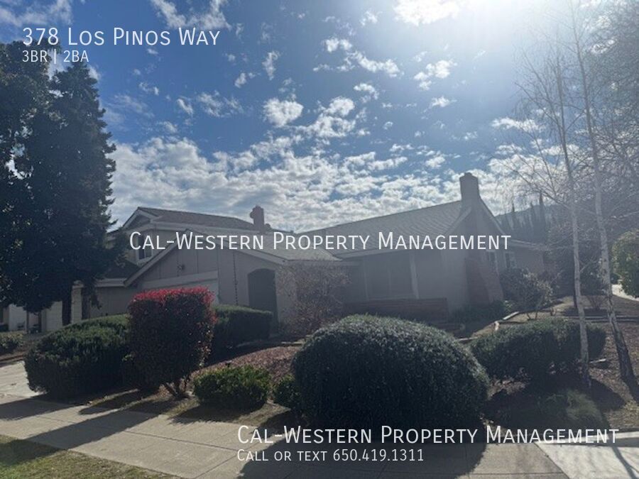
378 Los Pinos Way
San Jose, CA 95123
Today
|
Edit
Favorites
-
Bedrooms
3
-
Bathrooms
2
-
Square Feet
1,203 sq ft
378 Los Pinos Way

Favorites
About This Home
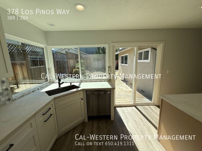
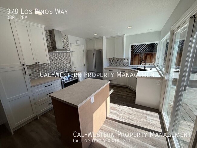
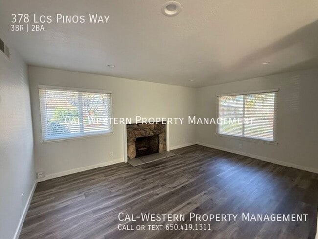
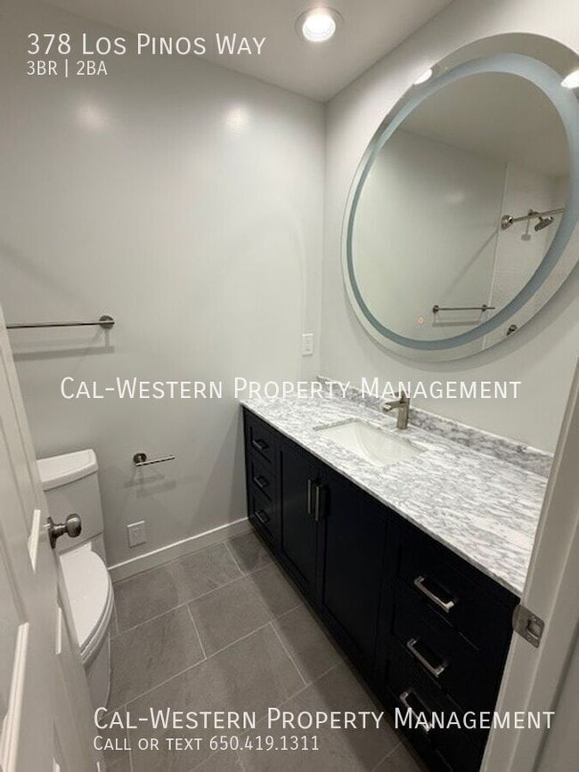
This three bedroom two bath home is absolutely gorgeous. Recently been remodeled to include, new kitchen cabinets, new counters, new stainless appliances, new sink, new faucet. Both bathrooms have been remodeled with new vanities, new tile, new commodes. Recessed lights in the living room, dining room, baths, and hallway. New wood flooring throughout. New blinds and dual pane windows. Yards are low maintenance and manicured. Trash included with the rent. Must have good credit. Income must be 3X the amount of the rent. Sorry, no pets Taylor Elementary Bernal Intermediate Santa Teresa High Tenant to verify school enrollment
378 Los Pinos Way is a house located in Santa Clara County and the 95123 ZIP Code. This area is served by the Oak Grove Elementary attendance zone.
* Price shown is base rent. Excludes user-selected optional fees and variable or usage-based fees and required charges due at or prior to move-in or at move-out. Price, availability, fees, and any applicable rent special are subject to change without notice.
* Square footage definitions vary. Displayed square footage is approximate.
Contact
- Listed by Leasing Agent
Location
Get Directions
Blossom Valley is a neighborhood in San Jose situated along Highway 85 between the Sierra Azul Preserve and the Diablo Range. The neighborhood is densely populated with several apartments and a few spacious homes for rent. An abundance of shopping and dining options at large retail centers like Westfield Oakridge are located in town as well. More retailers and eateries are scattered throughout the neighborhood, and a few community parks like Comanche Lookout Park dot the area. Parks, golf courses, and trails surround Blossom Valley, and outdoor enthusiasts have easy access to the massive state parks on either side of town.
Learn more about living in Blossom Valley/S San Jose
Education
| Colleges & Universities | Distance | ||
|---|---|---|---|
| Colleges & Universities | Distance | ||
| Drive: | 16 min | 7.9 mi | |
| Drive: | 18 min | 11.4 mi | |
| Drive: | 18 min | 12.1 mi | |
| Drive: | 22 min | 14.1 mi |
378 Los Pinos Way is within 16 minutes or 7.9 miles from Evergreen Valley College. It is also near San Jose State University and San Jose City College.
Schools


Public Elementary School
Grades K-6
497 Students
Attendance Zone
Public Elementary School
Grades K-5
500 Students
Nearby
Public Middle School
Grades 7-8
675 Students
Attendance Zone
Public High School
Grades 9-12
2,134 Students
Attendance Zone
Private Elementary & Middle School
Grades PK-8
259 Students
Nearby
Private Elementary, Middle & High School
Grades K-12
217 Students
Nearby
School data provided by
 The GreatSchools Rating helps parents compare schools within a state based on a variety of school quality indicators and provides a helpful picture of how effectively each school serves all of its students. Ratings are on a scale of 1 (below average) to 10 (above average) and can include test scores, college readiness, academic progress, advanced courses, equity, discipline and attendance data. We also advise parents to visit schools, consider other information on school performance and programs, and consider family needs as part of the school selection process.
View GreatSchools Rating Methodology
Data provided by GreatSchools.org © 2026. All rights reserved.
View GreatSchools Rating Methodology
Data provided by GreatSchools.org © 2026. All rights reserved.
Transportation options available in San Jose include Santa Teresa Station, located 1.6 miles from 378 Los Pinos Way. 378 Los Pinos Way is near Norman Y Mineta San Jose International, located 13.6 miles or 20 minutes away.
| Transit / Subway | Distance | ||
|---|---|---|---|
| Transit / Subway | Distance | ||
|
|
Drive: | 4 min | 1.6 mi |
|
|
Drive: | 4 min | 2.7 mi |
| Drive: | 4 min | 2.8 mi | |
|
|
Drive: | 6 min | 3.7 mi |
| Drive: | 8 min | 5.6 mi |
| Commuter Rail | Distance | ||
|---|---|---|---|
| Commuter Rail | Distance | ||
| Drive: | 5 min | 2.4 mi | |
| Drive: | 11 min | 5.4 mi | |
| Drive: | 14 min | 9.3 mi | |
| Drive: | 15 min | 10.6 mi | |
| Drive: | 16 min | 10.8 mi |
| Airports | Distance | ||
|---|---|---|---|
| Airports | Distance | ||
|
Norman Y Mineta San Jose International
|
Drive: | 20 min | 13.6 mi |
Time and distance from 378 Los Pinos Way.
| Shopping Centers | Distance | ||
|---|---|---|---|
| Shopping Centers | Distance | ||
| Walk: | 9 min | 0.5 mi | |
| Walk: | 10 min | 0.6 mi | |
| Drive: | 3 min | 1.3 mi |
378 Los Pinos Way has 3 shopping centers within 1.3 miles, which is about a 3-minute drive. The miles and minutes will be for the farthest away property.
| Parks and Recreation | Distance | ||
|---|---|---|---|
| Parks and Recreation | Distance | ||
|
Santa Teresa County Park
|
Drive: | 11 min | 3.6 mi |
|
Almaden Lake Park
|
Drive: | 9 min | 4.4 mi |
|
Coyote Creek Parkway
|
Drive: | 8 min | 4.8 mi |
|
Hellyer County Park
|
Drive: | 10 min | 5.1 mi |
|
Calero County Park
|
Drive: | 14 min | 7.8 mi |
378 Los Pinos Way has 5 parks within 7.8 miles, including Santa Teresa County Park, Almaden Lake Park, and Hellyer County Park.
| Hospitals | Distance | ||
|---|---|---|---|
| Hospitals | Distance | ||
| Walk: | 14 min | 0.8 mi | |
| Drive: | 6 min | 3.2 mi | |
| Drive: | 14 min | 9.6 mi |
378 Los Pinos Way has 3 hospitals within 9.6 miles, the nearest is Kaiser Foundation Hospital - San Jose which is 0.8 mile away and a 14 minute walk.
| Military Bases | Distance | ||
|---|---|---|---|
| Military Bases | Distance | ||
| Drive: | 31 min | 22.7 mi |
378 Los Pinos Way is 22.7 miles and a 31 minute drive from Ames Research Center.
You May Also Like
Similar Rentals Nearby


What Are Walk Score®, Transit Score®, and Bike Score® Ratings?
Walk Score® measures the walkability of any address. Transit Score® measures access to public transit. Bike Score® measures the bikeability of any address.
What is a Sound Score Rating?
A Sound Score Rating aggregates noise caused by vehicle traffic, airplane traffic and local sources

378 Los Pinos Way
San Jose, CA 95123