
$2,900 / Month
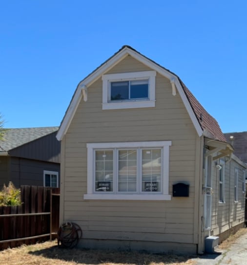
372 Sixth Ave
Menlo Park, CA 94025
Today
Favorites
510-921-9096
-
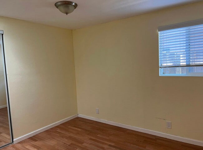
Bedrooms
1
-
Bathrooms
1
-
Square Feet
520 sq ft
-
Available
Available Aug 11
372 Sixth Ave

Favorites
About This Home
$3,300 deposit,
Available Aug 11
Great location nice neighborhood
372 Sixth Ave is a house located in San Mateo County and the 94025 ZIP Code. This area is served by the Redwood City Elementary attendance zone.
* Price shown is base rent and may not include non-optional fees and utilities.
Price, availability, fees, and any applicable rent special are subject to change without notice.
* Square footage definitions vary. Displayed square footage is approximate.
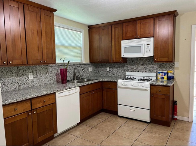
House Features
- Dishwasher
Fees and Policies
The fees below are based on community-supplied data and may exclude additional fees and utilities.
- Dogs Allowed
-
Fees not specified
- Cats Allowed
-
Fees not specified
Contact
- Listed by Shao Spidell
- Phone Number
- Contact
Location
Get Directions
Amenities
- Dishwasher
The Fair Oaks neighborhood provides a pleasant mix of residential homes and apartments for rent and features several commercial enterprises. Inside the neighborhood, bus stops dot the streets, making it easy to get downtown or to local hotspots. Atherton Station offers train service to other parts of California for residents who want to get away for a weekend.
In the mornings, locals stop by the Donut Depot for their morning fix of donuts and donut holes. When locals want something with a kick, they head to Taqueria Apatzingan for authentic Mexican food. Chile Colorado, chicken enchiladas, and nachos are just a few of the popular dishes that fly out of the kitchen.
Learn more about living in Fair Oaks
Education
| Colleges & Universities | Distance | ||
|---|---|---|---|
| Colleges & Universities | Distance | ||
| Drive: | 5 min | 1.8 mi | |
| Drive: | 14 min | 5.3 mi | |
| Drive: | 14 min | 5.3 mi | |
| Drive: | 15 min | 8.9 mi |
372 Sixth Ave is within 5 minutes or 1.8 miles from Menlo College. It is also near Stanford University and Canada College.
Schools


Public Elementary & Middle School
Grades K-8
515 Students
Attendance Zone
Public Elementary School
Grades K-5
367 Students
Nearby
Public High School
Grades 9-12
1,694 Students
Attendance Zone
Private Elementary, Middle & High School
Grades 3-12
10 Students
Nearby
Private Elementary & Middle School
Grades PK-8
Nearby
School data provided by
 The GreatSchools Rating helps parents compare schools within a state based on a variety of school quality indicators and provides a helpful picture of how effectively each school serves all of its students. Ratings are on a scale of 1 (below average) to 10 (above average) and can include test scores, college readiness, academic progress, advanced courses, equity, discipline and attendance data. We also advise parents to visit schools, consider other information on school performance and programs, and consider family needs as part of the school selection process.
View GreatSchools Rating Methodology
Data provided by GreatSchools.org © 2025. All rights reserved.
View GreatSchools Rating Methodology
Data provided by GreatSchools.org © 2025. All rights reserved.
Transportation options available in Menlo Park include Bayshore Nasa Station, located 11.3 miles from 372 Sixth Ave. 372 Sixth Ave is near San Francisco International, located 16.4 miles or 24 minutes away, and Norman Y Mineta San Jose International, located 18.8 miles or 26 minutes away.
| Transit / Subway | Distance | ||
|---|---|---|---|
| Transit / Subway | Distance | ||
| Drive: | 16 min | 11.3 mi | |
|
|
Drive: | 17 min | 11.4 mi |
| Drive: | 17 min | 11.7 mi | |
|
|
Drive: | 17 min | 11.7 mi |
|
|
Drive: | 18 min | 11.8 mi |
| Commuter Rail | Distance | ||
|---|---|---|---|
| Commuter Rail | Distance | ||
| Drive: | 5 min | 1.9 mi | |
| Drive: | 6 min | 2.2 mi | |
| Drive: | 9 min | 3.4 mi | |
| Drive: | 11 min | 4.3 mi | |
| Drive: | 13 min | 5.2 mi |
| Airports | Distance | ||
|---|---|---|---|
| Airports | Distance | ||
|
San Francisco International
|
Drive: | 24 min | 16.4 mi |
|
Norman Y Mineta San Jose International
|
Drive: | 26 min | 18.8 mi |
Time and distance from 372 Sixth Ave.
| Shopping Centers | Distance | ||
|---|---|---|---|
| Shopping Centers | Distance | ||
| Walk: | 15 min | 0.8 mi | |
| Drive: | 4 min | 1.2 mi | |
| Drive: | 3 min | 1.2 mi |
372 Sixth Ave has 3 shopping centers within 1.2 miles, which is about a 3-minute walk. The miles and minutes will be for the farthest away property.
| Parks and Recreation | Distance | ||
|---|---|---|---|
| Parks and Recreation | Distance | ||
|
Holbrook-Palmer Park
|
Drive: | 4 min | 1.3 mi |
|
Fremont Park
|
Drive: | 7 min | 2.5 mi |
|
Burgess Park
|
Drive: | 7 min | 2.8 mi |
|
Red Morton Park
|
Drive: | 8 min | 3.0 mi |
|
Jack W. Lyle Park
|
Drive: | 7 min | 3.0 mi |
372 Sixth Ave has 5 parks within 3.0 miles, including Holbrook-Palmer Park, Fremont Park, and Red Morton Park.
| Hospitals | Distance | ||
|---|---|---|---|
| Hospitals | Distance | ||
| Drive: | 5 min | 2.1 mi | |
| Drive: | 9 min | 3.4 mi | |
| Drive: | 10 min | 4.0 mi |
372 Sixth Ave has 3 hospitals within 4.0 miles, the nearest is Kaiser Foundation Hospital - Redwood City which is 2.1 miles away and a 5 minute drive.
| Military Bases | Distance | ||
|---|---|---|---|
| Military Bases | Distance | ||
| Drive: | 19 min | 11.7 mi |
372 Sixth Ave is 11.7 miles and a 19 minute drive from Ames Research Center.
You May Also Like
Similar Rentals Nearby


What Are Walk Score®, Transit Score®, and Bike Score® Ratings?
Walk Score® measures the walkability of any address. Transit Score® measures access to public transit. Bike Score® measures the bikeability of any address.
What is a Sound Score Rating?
A Sound Score Rating aggregates noise caused by vehicle traffic, airplane traffic and local sources

372 Sixth Ave
Menlo Park, CA 94025