
$4,400 / Month
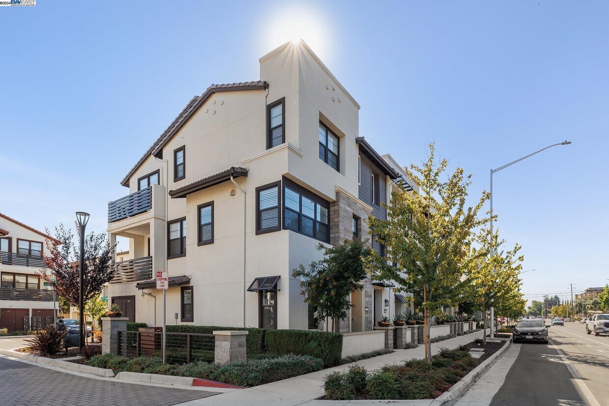
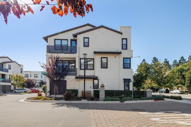
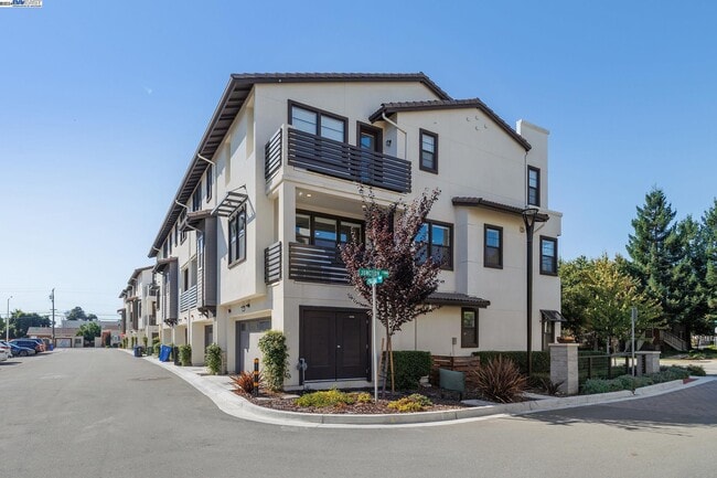
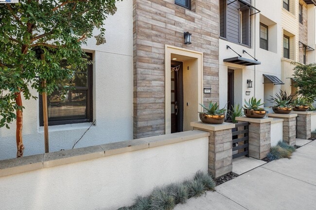
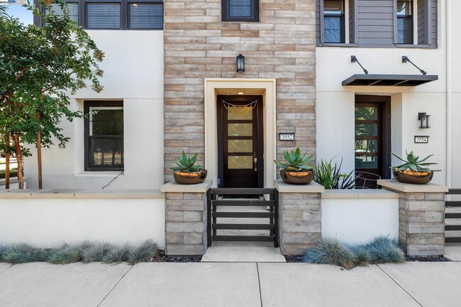
3552 Peralta Blvd
Fremont, CA 94536
2 Weeks Ago
Favorites
3552 Peralta Blvd

Favorites
Check Back Soon for Upcoming Availability
| Beds | Baths | Average SF |
|---|---|---|
| 3 Bedrooms 3 Bedrooms 3 Br | 3.5 Baths 3.5 Baths 3.5 Ba | 1,729 SF |
About This Property
The residence at 3552 Peralta Blvd in Fremont is thoughtfully designed to cater to modern lifestyles,featuring a spacious layout with 3 bedrooms and 3.5 bathrooms. Each bedroom offers ample space for comfort and privacy,and the bathrooms boast modern fixtures. The kitchen is equipped with top-of-the-line appliances and extensive counter space,perfect for meal prep and family time. One of the standout features of this home is its electric vehicle (EV) charging station,which provides convenience for EV owners. Additionally,the house offers generous storage space. Another notable feature is the home's ample natural lighting,which floods the space with warmth and brightness. Nestled in a desirable neighborhood of Fremont,the property is surrounded by essential amenities such as schools,parks,shopping centers,and enjoys easy access to major transportation routes,ensuring a smooth commute and quick trips to urban centers. Prospective tenants are required to provide a credit report and other necessary documentation to move forward with the rental application. Responsibilities for utilities,including water,trash,gas,electricity,and internet,will be outlined in the lease agreement. The home is ready for occupancy on May 17,2024.
3552 Peralta Blvd is a condo located in Alameda County and the 94536 ZIP Code. This area is served by the Fremont Unified attendance zone.
Location
Get Directions
As its name implies, Centerville is a neighborhood located in central Fremont. Filled with tree-lined streets, Centerville has mid-range to upscale rentals available, including cozy single-family homes and luxury apartments. Centerville is family-friendly with several great schools and daycare centers located in the community. Renters from all walks of life enjoy Centerville’s amazing location. Along with bordering Downtown Fremont, Centerville is convenient to some of Fremont’s most popular parks and trailheads including Quarry Lakes Regional Recreation Area, a 471-acre local favorite for picnics, fishing, swimming, and boating.
Silicon Valley commuters enjoy having a train station in town, while Highway 84 and Interstate 880 are used by those who prefer to drive. Fremont Boulevard has a variety of restaurants, shops, event venues, and other businesses, providing residents with plenty of amenities not far from home.
Learn more about living in CentervilleBelow are rent ranges for similar nearby apartments
Education
| Colleges & Universities | Distance | ||
|---|---|---|---|
| Colleges & Universities | Distance | ||
| Drive: | 8 min | 4.7 mi | |
| Drive: | 14 min | 6.2 mi | |
| Drive: | 17 min | 11.3 mi | |
| Drive: | 18 min | 12.1 mi |
3552 Peralta Blvd is within 8 minutes or 4.7 miles from Ohlone College, Newark. It is also near Ohlone College, Fremont Campus and Chabot College.
Schools


Public Elementary School
Grades K-5
343 Students
Nearby
Public Elementary School
Grades 1-5
890 Students
Attendance Zone
Public Middle School
Grades 6-8
946 Students
Attendance Zone
Public High School
Grades 9-12
1,931 Students
Attendance Zone
Private Elementary, Middle & High School
Grades PK-12
691 Students
Nearby
Private Elementary School
Grades PK-2
Nearby
Private Elementary & Middle School
Grades PK-8
285 Students
Nearby
School data provided by
 The GreatSchools Rating helps parents compare schools within a state based on a variety of school quality indicators and provides a helpful picture of how effectively each school serves all of its students. Ratings are on a scale of 1 (below average) to 10 (above average) and can include test scores, college readiness, academic progress, advanced courses, equity, discipline and attendance data. We also advise parents to visit schools, consider other information on school performance and programs, and consider family needs as part of the school selection process.
View GreatSchools Rating Methodology
Data provided by GreatSchools.org © 2025. All rights reserved.
View GreatSchools Rating Methodology
Data provided by GreatSchools.org © 2025. All rights reserved.
Transportation options available in Fremont include Fremont Station, located 1.7 miles from 3552 Peralta Blvd. 3552 Peralta Blvd is near Norman Y Mineta San Jose International, located 19.5 miles or 26 minutes away, and Metro Oakland International, located 20.1 miles or 27 minutes away.
| Transit / Subway | Distance | ||
|---|---|---|---|
| Transit / Subway | Distance | ||
|
|
Drive: | 4 min | 1.7 mi |
|
|
Drive: | 4 min | 1.9 mi |
|
|
Drive: | 8 min | 4.2 mi |
|
|
Drive: | 13 min | 6.0 mi |
|
|
Drive: | 15 min | 10.0 mi |
| Commuter Rail | Distance | ||
|---|---|---|---|
| Commuter Rail | Distance | ||
| Walk: | 10 min | 0.5 mi | |
| Walk: | 10 min | 0.5 mi | |
| Drive: | 16 min | 11.9 mi | |
|
|
Drive: | 16 min | 11.9 mi |
| Drive: | 25 min | 16.5 mi |
| Airports | Distance | ||
|---|---|---|---|
| Airports | Distance | ||
|
Norman Y Mineta San Jose International
|
Drive: | 26 min | 19.5 mi |
|
Metro Oakland International
|
Drive: | 27 min | 20.1 mi |
Time and distance from 3552 Peralta Blvd.
| Shopping Centers | Distance | ||
|---|---|---|---|
| Shopping Centers | Distance | ||
| Walk: | 3 min | 0.2 mi | |
| Walk: | 14 min | 0.8 mi | |
| Walk: | 15 min | 0.8 mi |
3552 Peralta Blvd has 3 shopping centers within 0.8 mile, which is about a 15-minute walk. The miles and minutes will be for the farthest away property.
| Parks and Recreation | Distance | ||
|---|---|---|---|
| Parks and Recreation | Distance | ||
|
Quarry Lakes Regional Recreation Area
|
Drive: | 4 min | 2.1 mi |
|
Alameda Creek Regional Trail
|
Drive: | 4 min | 2.3 mi |
|
Central Park (Lake Elizabeth)
|
Drive: | 7 min | 2.7 mi |
|
Niles Canyon Railway
|
Drive: | 6 min | 3.3 mi |
|
Niles Community Park
|
Drive: | 8 min | 3.8 mi |
3552 Peralta Blvd has 5 parks within 3.8 miles, including Quarry Lakes Regional Recreation Area, Alameda Creek Regional Trail, and Niles Community Park.
| Hospitals | Distance | ||
|---|---|---|---|
| Hospitals | Distance | ||
| Drive: | 3 min | 1.7 mi | |
| Drive: | 3 min | 1.8 mi | |
| Drive: | 13 min | 9.1 mi |
3552 Peralta Blvd has 3 hospitals within 9.1 miles, the nearest is Kaiser Foundation Hospital - Fremont which is 1.7 miles away and a 3 minute drive.
| Military Bases | Distance | ||
|---|---|---|---|
| Military Bases | Distance | ||
| Drive: | 31 min | 22.3 mi |
3552 Peralta Blvd is 22.3 miles and a 31 minute drive from Ames Research Center.
You May Also Like
Similar Rentals Nearby
-
-

-

-
 $3,5003 Beds, 1.5 Baths, 1,129 sq ftApartment for Rent
 -

-

-
 $4,3503 Beds, 2 Baths, 1,361 sq ftApartment for Rent
 -
 $7,5003 Beds, 2.5 Baths, 1,980 sq ftApartment for Rent
 -
 $5,2003 Beds, 2 Baths, 1,216 sq ftApartment for Rent
 -
 $4,9503 Beds, 2 Baths, 1,340 sq ftCondo for Rent
What Are Walk Score®, Transit Score®, and Bike Score® Ratings?
Walk Score® measures the walkability of any address. Transit Score® measures access to public transit. Bike Score® measures the bikeability of any address.
What is a Sound Score Rating?
A Sound Score Rating aggregates noise caused by vehicle traffic, airplane traffic and local sources

3552 Peralta Blvd
Fremont, CA 94536