

$3,950 / Month
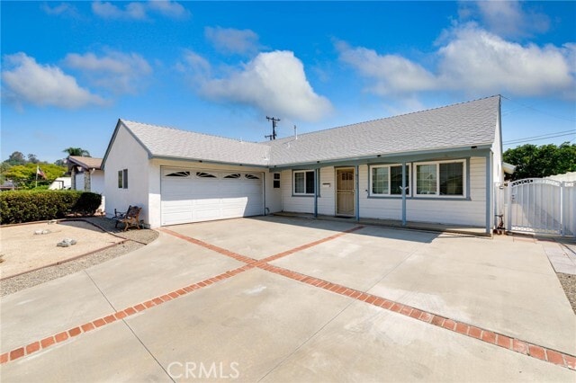
3532 Camino de Teodoro
West Covina, CA 91792
Today
Favorites
888-584-9427
-
Bedrooms
4
-
Bathrooms
2
-
Square Feet
1,702 sq ft
-
Available
Available Now
Highlights
- Open Floorplan
- 2 Car Direct Access Garage
- Front Porch
- Eat-In Kitchen
- Bathtub with Shower
- Patio
3532 Camino de Teodoro

Favorites
About This Home
12 Month Lease,
$3,950 deposit,
Available Now
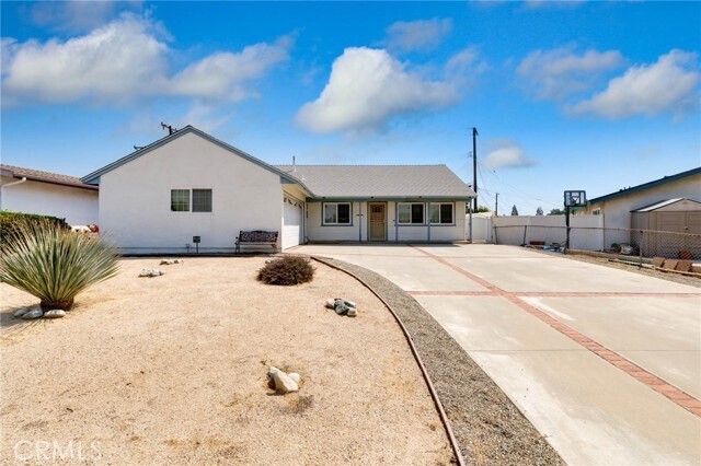
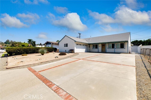
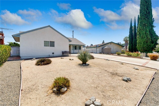
** Award-Winning Walnut Valley Schools! ** Live in West Covina with the benefit of top-rated Walnut Valley Unified School District! This single-story 4 bed, 2 bath home (1,702 sq. ft. + bonus sunroom) offers a spacious front yard, oversized driveway, and low-maintenance desert landscaping. Enjoy a newly upgraded backyard with artificial turf—perfect for gatherings and play. Just minutes from shopping, dining, entertainment, and major freeways. Included with the home: Washer, Dryer, Refrigerator, Ring Doorbell, Nest Thermostat, Water Filter, ADT pre-wiring, Dining Table & Chairs set, and two queen bed frames. Homes like this don’t last—act fast! MLS# PW25181334
3532 Camino de Teodoro is a house located in Los Angeles County and the 91792 ZIP Code. This area is served by the Walnut Valley Unified attendance zone.
* Price shown is base rent and may not include non-optional fees and utilities.
Price, availability, fees, and any applicable rent special are subject to change without notice.
* Square footage definitions vary. Displayed square footage is approximate.
Home Details
Home Type
Single Family Detached Home
Year Built
Built in 1964
Accessible Home Design
Entry on the 2nd floor
Bedrooms and Bathrooms
Bathtub with Shower
Walk-in Shower
4 Main Level Bedrooms
2 Full Bathrooms
Flooring
Carpet
Vinyl
Home Design
Turnkey
Home Security
Carbon Monoxide Detectors
Fire and Smoke Detector
Security Lights
Alarm System
Interior Spaces
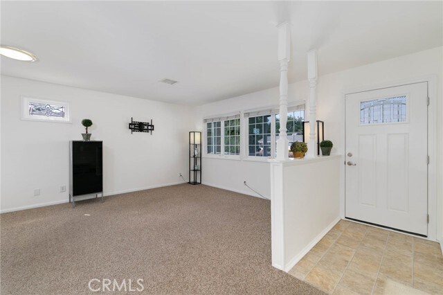
Open Floorplan
Living Room
Recessed Lighting
Ceiling Fan
Family Room
Partially Furnished
Entryway
1,702 Sq Ft Home
1-Story Property
Kitchen
Eat-In Kitchen
Free-Standing Range
Microwave
Laundry
Laundry Room
Dryer
Washer
Listing and Financial Details
Security Deposit $3,950
12-Month Minimum Lease Term
Available 8/16/25
Tax Lot 126
Tax Tract Number 27416
Assessor Parcel Number 8724008047
Rent includes gardener
Lot Details
6,067 Sq Ft Lot
No Common Walls
Fenced
Front Yard
Fence is in average condition
Property is zoned WCR1AD1*
Outdoor Features
Front Porch
Patio
Exterior Lighting
Parking
2 Car Direct Access Garage
Parking Available
Driveway
Schools
South Pointe Middle School
Walnut High School
Utilities
Central Heating and Cooling System
Cable TV Available
Natural Gas Connected
Septic Type Unknown
Community Details
Overview
No Home Owners Association
Pet Policy
Cats Allowed
Limit on the number of pets
Pet Deposit $400
Fees and Policies
The fees below are based on community-supplied data and may exclude additional fees and utilities.
- Cats Allowed
-
Fees not specified
-
Weight limit--
-
Pet Limit--
- Parking
-
Garage--
-
Other--
Details
Lease Options
-
12 Months
Property Information
-
Furnished Units Available
Contact
- Listed by William Lin | eXp Realty of California Inc
- Phone Number
- Contact
-
Source
 California Regional Multiple Listing Service
Copyright 2025 © California Regional MLS. All rights reserved.
Location
Get Directions
Amenities
- Washer/Dryer
- Air Conditioning
- Heating
- Microwave
- Range
- Refrigerator
- Carpet
- Vinyl Flooring
- Furnished
- Fenced Lot
- Patio
Walnut Valley is a picturesque community in the San Gabriel Valley. Its rolling hills and proximity to major Southern California cities like Los Angeles, located 30 miles west, make Walnut Valley an ideal spot to settle down. Its southern border partially encompasses Chino Hills State Park, ensuring that outdoor recreation is always available. More outdoor recreation is nearby, with the Angeles National Forest being just a short drive north of town. Inside Walnut Valley, business centers, shopping plazas, and other commercial developments dot the area, providing essentials close to home. Walnut Valley provides a variety of single-family homes and apartments for rent.
Learn more about living in Walnut Valley
Education
| Colleges & Universities | Distance | ||
|---|---|---|---|
| Colleges & Universities | Distance | ||
| Drive: | 7 min | 3.5 mi | |
| Drive: | 13 min | 6.1 mi | |
| Drive: | 14 min | 6.6 mi | |
| Drive: | 17 min | 9.5 mi |
3532 Camino de Teodoro is within 7 minutes or 3.5 miles from Mt. San Antonio College. It is also near Cal Poly Pomona and DeVry University-California.
Schools


Public Elementary School
Grades K-5
484 Students
Attendance Zone
Public Elementary School
Grades K-6
257 Students
Nearby
Public Middle School
Grades 6-8
879 Students
Attendance Zone
Public High School
Grades 9-12
2,158 Students
Attendance Zone
Private Elementary School
Grades PK-6
Nearby
Private Elementary, Middle & High School
Grades 1-12
Nearby
School data provided by
 The GreatSchools Rating helps parents compare schools within a state based on a variety of school quality indicators and provides a helpful picture of how effectively each school serves all of its students. Ratings are on a scale of 1 (below average) to 10 (above average) and can include test scores, college readiness, academic progress, advanced courses, equity, discipline and attendance data. We also advise parents to visit schools, consider other information on school performance and programs, and consider family needs as part of the school selection process.
View GreatSchools Rating Methodology
Data provided by GreatSchools.org © 2025. All rights reserved.
View GreatSchools Rating Methodology
Data provided by GreatSchools.org © 2025. All rights reserved.
Transportation options available in West Covina include Azusa Downtown Station, located 10.8 miles from 3532 Camino de Teodoro. 3532 Camino de Teodoro is near Ontario International, located 20.2 miles or 28 minutes away, and Long Beach (Daugherty Field), located 31.5 miles or 42 minutes away.
| Transit / Subway | Distance | ||
|---|---|---|---|
| Transit / Subway | Distance | ||
| Drive: | 19 min | 10.8 mi | |
| Drive: | 22 min | 12.0 mi | |
| Drive: | 22 min | 12.1 mi | |
| Drive: | 24 min | 14.8 mi |
| Commuter Rail | Distance | ||
|---|---|---|---|
| Commuter Rail | Distance | ||
|
|
Drive: | 6 min | 2.5 mi |
|
|
Drive: | 16 min | 8.9 mi |
|
|
Drive: | 16 min | 9.0 mi |
|
|
Drive: | 18 min | 10.1 mi |
|
|
Drive: | 20 min | 11.3 mi |
| Airports | Distance | ||
|---|---|---|---|
| Airports | Distance | ||
|
Ontario International
|
Drive: | 28 min | 20.2 mi |
|
Long Beach (Daugherty Field)
|
Drive: | 42 min | 31.5 mi |
Time and distance from 3532 Camino de Teodoro.
| Shopping Centers | Distance | ||
|---|---|---|---|
| Shopping Centers | Distance | ||
| Walk: | 18 min | 1.0 mi | |
| Walk: | 18 min | 1.0 mi | |
| Drive: | 3 min | 1.5 mi |
3532 Camino de Teodoro has 3 shopping centers within 1.5 miles, which is about a 3-minute walk. The miles and minutes will be for the farthest away property.
| Parks and Recreation | Distance | ||
|---|---|---|---|
| Parks and Recreation | Distance | ||
|
Galster Wilderness Park Nature Center
|
Drive: | 11 min | 5.4 mi |
|
Schabarum Regional Park
|
Drive: | 13 min | 6.1 mi |
|
Covina Park
|
Drive: | 15 min | 8.2 mi |
|
La Habra Historical Museum
|
Drive: | 15 min | 8.6 mi |
|
Frank G. Bonelli Regional Park
|
Drive: | 17 min | 11.4 mi |
3532 Camino de Teodoro has 5 parks within 11.4 miles, including Galster Wilderness Park Nature Center, Schabarum Regional Park, and Covina Park.
| Hospitals | Distance | ||
|---|---|---|---|
| Hospitals | Distance | ||
| Drive: | 15 min | 7.5 mi | |
| Drive: | 15 min | 8.0 mi | |
| Drive: | 15 min | 8.5 mi |
3532 Camino de Teodoro has 3 hospitals within 8.5 miles, the nearest is West Covina Medical Center which is 7.5 miles away and a 15 minute drive.
| Military Bases | Distance | ||
|---|---|---|---|
| Military Bases | Distance | ||
| Drive: | 39 min | 22.9 mi |
3532 Camino de Teodoro is 22.9 miles and a 39 minute drive from Los Alamitos Army Airfield.
You May Also Like
Similar Rentals Nearby


What Are Walk Score®, Transit Score®, and Bike Score® Ratings?
Walk Score® measures the walkability of any address. Transit Score® measures access to public transit. Bike Score® measures the bikeability of any address.
What is a Sound Score Rating?
A Sound Score Rating aggregates noise caused by vehicle traffic, airplane traffic and local sources
3532 Camino de Teodoro
West Covina, CA 91792