
| 1 | $50,000 |
| 2 | $75,000 |
Favorites
609-473-3769
-
Monthly Rent
$1,499
-
Bedrooms
1 bd
-
Bathrooms
1 ba
-
Square Feet
900 sq ft
353 High St Unit 4

Favorites
Apartamento histórico Art Deco | A pie de la ribera y el tren | Aprox. 900 pies cuadrados Viva en uno de los edificios más distintivos de Burlington. Este luminoso apartamento está ubicado en un notable edificio de mampostería Art Deco / Streamlined Moderne, reconocido por su arquitectura única de esquinas curvas y su carácter histórico. Situado dentro del Distrito Histórico de Burlington, incluido en los Registros de Lugares Históricos de Nueva Jersey y Nacional, disfrutará del encanto de una comunidad ribereña transitable a pie, rica en historia, arte, gastronomía y eventos locales. Puntos destacados de la ubicación A 3 minutos a pie de la estación de tren River Line 5 rutas de autobús cercanas A minutos del paseo marítimo de Burlington Camine hasta restaurantes, Evermore Coffee, tiendas locales y una popular microcervecería Al otro lado de la calle de un renombrado mercado de antigüedades con 87 comerciantes y nuevos descubrimientos cada semana Disfrute de mercados de agricultores de temporada, ferias callejeras, festivales y eventos comunitarios Acceso conveniente a Filadelfia y sus alrededores Características del apartamento Aprox. 900 pies cuadrados Espacios luminosos con abundante luz natural Ventanas modernas de doble panel Amplio vestidor y espacio de almacenamiento Cocina recién remodelada con electrodomésticos de acero inoxidable Cocina y baño con azulejos Suelo laminado en todas las áreas de estar Sistema de alarma contra incendios monitoreado profesionalmente las 24 horas, los 7 días de la semana Características del edificio Arquitectura histórica Art Deco / Streamlined Moderne Áreas comunes recién pintadas Iluminación moderna con detector de movimiento Acceso directo al apartamento desde la escalera principal Protección de alarma contra incendios monitoreada profesionalmente las 24 horas, los 7 días de la semana Aspectos destacados del vecindario Paseo marítimo de Burlington a lo largo del histórico río Delaware, perfecto para caminar, trotar, andar en bicicleta y disfrutar de las vistas al río Instalaciones de arte público y murales en todo el distrito histórico Histórica estación de bomberos Olde Burlington, abierta durante festivales y eventos comunitarios selectos Ambiente vibrante del centro con tiendas, restaurantes, cafés y eventos durante todo el año Estacionamiento Estacionamiento en la calle justo afuera del edificio Estacionamiento privado disponible cerca (sujeto a disponibilidad) Gran estacionamiento público con aproximadamente 200 espacios a solo 5 minutos a pie Política de mascotas Se permite un perro pequeño (sujeto a aprobación) Una rara oportunidad de disfrutar de la comodidad moderna dentro de un Un lugar emblemático e histórico de Burlington, a pocos pasos de la ribera del río Delaware, el transporte público, restaurantes, tiendas y eventos comunitarios.
Highlights
- Frente al mar
- Vestidores
Pricing & Floor Plans
1 Hab 1 Baño
$1,499
1 Bed
1 Bath
900 Sq Ft
1 Available unit
Unit
Base Price
Sq Ft
Availability
Unit Details
-
Unit 4price $1,499square feet 900availibility Now
1 Hab 1 Baño
$1,499
1 Bed
1 Bath
900 Sq Ft
1 Available unit
Unit
Base Price
Sq Ft
Availability
Unit Details
-
Unit 4price $1,499square feet 900availibility Now
* Price shown is base rent. Excludes user-selected optional fees and variable or usage-based fees and required charges due at or prior to move-in or at move-out.View Fees and Policies for details.
Price, availability, fees, and any applicable rent special are subject to change without notice.
* Square footage definitions vary. Displayed square footage is approximate.
Fees and Policies
The fees listed below are community-provided and may exclude utilities or add-ons. All payments are made directly to the property and are non-refundable unless otherwise specified.
Pet policies are negotiable.
-
Street Parking
-
Other5 minutes walk free, 200-spot Parking Lot
Property Fee Disclaimer: Based on community-supplied data and independent market research. Subject to change without notice. May exclude fees for mandatory or optional services and usage-based utilities.
Details
Utilities Included
-
Trash Removal
-
Air Conditioning
Lease Options
-
Contratos de arrendamiento de 12 - 46 meses
Property Information
-
Built in 1941
-
5 units/2 stories
About 353 High St Burlington, NJ 08016
Apartamento histórico Art Deco | A pie de la ribera y el tren | Aprox. 900 pies cuadrados Viva en uno de los edificios más distintivos de Burlington. Este luminoso apartamento está ubicado en un notable edificio de mampostería Art Deco / Streamlined Moderne, reconocido por su arquitectura única de esquinas curvas y su carácter histórico. Situado dentro del Distrito Histórico de Burlington, incluido en los Registros de Lugares Históricos de Nueva Jersey y Nacional, disfrutará del encanto de una comunidad ribereña transitable a pie, rica en historia, arte, gastronomía y eventos locales. Puntos destacados de la ubicación A 3 minutos a pie de la estación de tren River Line 5 rutas de autobús cercanas A minutos del paseo marítimo de Burlington Camine hasta restaurantes, Evermore Coffee, tiendas locales y una popular microcervecería Al otro lado de la calle de un renombrado mercado de antigüedades con 87 comerciantes y nuevos descubrimientos cada semana Disfrute de mercados de agricultores de temporada, ferias callejeras, festivales y eventos comunitarios Acceso conveniente a Filadelfia y sus alrededores Características del apartamento Aprox. 900 pies cuadrados Espacios luminosos con abundante luz natural Ventanas modernas de doble panel Amplio vestidor y espacio de almacenamiento Cocina recién remodelada con electrodomésticos de acero inoxidable Cocina y baño con azulejos Suelo laminado en todas las áreas de estar Sistema de alarma contra incendios monitoreado profesionalmente las 24 horas, los 7 días de la semana Características del edificio Arquitectura histórica Art Deco / Streamlined Moderne Áreas comunes recién pintadas Iluminación moderna con detector de movimiento Acceso directo al apartamento desde la escalera principal Protección de alarma contra incendios monitoreada profesionalmente las 24 horas, los 7 días de la semana Aspectos destacados del vecindario Paseo marítimo de Burlington a lo largo del histórico río Delaware, perfecto para caminar, trotar, andar en bicicleta y disfrutar de las vistas al río Instalaciones de arte público y murales en todo el distrito histórico Histórica estación de bomberos Olde Burlington, abierta durante festivales y eventos comunitarios selectos Ambiente vibrante del centro con tiendas, restaurantes, cafés y eventos durante todo el año Estacionamiento Estacionamiento en la calle justo afuera del edificio Estacionamiento privado disponible cerca (sujeto a disponibilidad) Gran estacionamiento público con aproximadamente 200 espacios a solo 5 minutos a pie Política de mascotas Se permite un perro pequeño (sujeto a aprobación) Una rara oportunidad de disfrutar de la comodidad moderna dentro de un Un lugar emblemático e histórico de Burlington, a pocos pasos de la ribera del río Delaware, el transporte público, restaurantes, tiendas y eventos comunitarios.
353 High St is an apartment community located in Burlington County and the 08016 ZIP Code. This area is served by the Burlington City Public School District attendance zone.
Unique Features
- Aire centralizado nuevo
- Armarios incorporados
- Decorado con azulejos estilo metro
- Lavandería de alta calidad a 6 minutos. Walk Away
- Nuevos azulejos en pisos
- Unidad de aire acondicionado incluida
- Ventanas corredizas de ambos lados
Contact
Language:
English
Closed Today
Community Amenities
Instalaciones de lavandería
Acceso 24 horas
Almacén/trastero
Frente al mar
- Instalaciones de lavandería
- Acceso 24 horas
- Almacén/trastero
- Frente al mar
Apartment Features
Aire acondicionado
Vestidores
Nevera
Electrodomésticos de acero inoxidable
- Aire acondicionado
- Sistema de seguridad
- Electrodomésticos de acero inoxidable
- Cocina
- Nevera
- Suelos de vinilo
- Vestidores
- Ventanas de doble panel
Income Restrictions
Income restrictions apply to some or all residents. Contact the community for more information.
How To Qualify
Based on the size of your household, your Maximum Annual Income must be equal to or less than the amount listed in this chart.
| # Persons | Annual Income |
353 High St,
Burlington,
NJ
08016
A densely populated suburb of New Jersey, Burlington offers residents paved sidewalks, longstanding homes, and safe residential streets. This suburb’s historic charm comes from various sites and small businesses, including Doc’s Irish Pub, Third State Brewing, Amy’s Omelette House, and Brickwall Tavern. For views of the Delaware River, check out Curtin’s Wharf or Riverview on High Street where you can enjoy brunch, draft beers, and American eats all in one place.
Burlington sits about 20 miles northeast of Philadelphia, making it an ideal suburb for commuters. Interstate 295 is easily accessed just outside of town, and a few miles east you’ll find nearby gems like the Columbus Farmers Market. Rent in Burlington is reasonable, and with all of the unique amenities and small town charm, there’s something for everyone in this New Jersey suburb.
Learn more about living in Burlington
Amenities
- Instalaciones de lavandería
- Acceso 24 horas
- Almacén/trastero
- Frente al mar
- Aire centralizado nuevo
- Armarios incorporados
- Decorado con azulejos estilo metro
- Lavandería de alta calidad a 6 minutos. Walk Away
- Nuevos azulejos en pisos
- Unidad de aire acondicionado incluida
- Ventanas corredizas de ambos lados
- Aire acondicionado
- Sistema de seguridad
- Electrodomésticos de acero inoxidable
- Cocina
- Nevera
- Suelos de vinilo
- Vestidores
- Ventanas de doble panel
Expenses
Utilities Included
Trash Removal, Air Conditioning
Included
Office Hours
609-473-3769
| Monday | 8am - 9pm |
|---|---|
| Tuesday | 8am - 9pm |
| Wednesday | 8am - 9pm |
| Thursday | 8am - 9pm |
| Friday | 8am - 9pm |
| Saturday | Closed |
| Sunday | 10am - 9pm |
Education
| Colleges & Universities | Distance | ||
|---|---|---|---|
| Colleges & Universities | Distance | ||
| Drive: | 19 min | 9.3 mi | |
| Drive: | 16 min | 9.7 mi | |
| Drive: | 21 min | 10.9 mi | |
| Drive: | 25 min | 14.0 mi |
353 High St Unit 4 is within 19 minutes or 9.3 miles from Holy Family University. It is also near Burlington Co., Mount Laurel and C.C. of Philadelphia, NE Ctr.
Schools


Public Elementary School
Grades K-5
229 Students
Attendance Zone
Public Elementary School
Grades PK-5
310 Students
Nearby
Public Elementary School
Grades K-5
483 Students
Attendance Zone
Public Middle & High School
Grades 6-12
813 Students
Attendance Zone
Private Elementary, Middle & High School
Grades PK-12
252 Students
Nearby
Private Elementary & Middle School
Grades PK-8
40 Students
Nearby
School data provided by
 The GreatSchools Rating helps parents compare schools within a state based on a variety of school quality indicators and provides a helpful picture of how effectively each school serves all of its students. Ratings are on a scale of 1 (below average) to 10 (above average) and can include test scores, college readiness, academic progress, advanced courses, equity, discipline and attendance data. We also advise parents to visit schools, consider other information on school performance and programs, and consider family needs as part of the school selection process.
View GreatSchools Rating Methodology
Data provided by GreatSchools.org © 2026. All rights reserved.
The GreatSchools Rating helps parents compare schools within a state based on a variety of school quality indicators and provides a helpful picture of how effectively each school serves all of its students. Ratings are on a scale of 1 (below average) to 10 (above average) and can include test scores, college readiness, academic progress, advanced courses, equity, discipline and attendance data. We also advise parents to visit schools, consider other information on school performance and programs, and consider family needs as part of the school selection process.
View GreatSchools Rating Methodology
Data provided by GreatSchools.org © 2026. All rights reserved.
Transportation options available in Burlington include Burlington Towne Center, located 0.1 mile from 353 High St Unit 4. 353 High St Unit 4 is near Trenton Mercer, located 18.3 miles or 31 minutes away, and Philadelphia International, located 28.9 miles or 47 minutes away.
| Transit / Subway | Distance | ||
|---|---|---|---|
| Transit / Subway | Distance | ||
|
|
Walk: | 1 min | 0.1 mi |
|
|
Walk: | 19 min | 1.0 mi |
|
|
Drive: | 7 min | 3.6 mi |
|
|
Drive: | 7 min | 3.7 mi |
|
|
Drive: | 10 min | 6.1 mi |
| Commuter Rail | Distance | ||
|---|---|---|---|
| Commuter Rail | Distance | ||
| Drive: | 8 min | 3.6 mi | |
| Drive: | 9 min | 4.1 mi | |
| Drive: | 12 min | 5.9 mi | |
| Drive: | 13 min | 6.5 mi | |
|
|
Drive: | 14 min | 6.9 mi |
| Airports | Distance | ||
|---|---|---|---|
| Airports | Distance | ||
|
Trenton Mercer
|
Drive: | 31 min | 18.3 mi |
|
Philadelphia International
|
Drive: | 47 min | 28.9 mi |
Getting Around
 What do Walkability, Transit, Drivability, and Bikeability mean?
Walkability measures the walking distance to day-to-day needs.
Transit measures access to public transportation.
Drivability measures congestion, parking availability, and access to major roads.
Bikeability measures the suitability for cycling.
How It Works
What do Walkability, Transit, Drivability, and Bikeability mean?
Walkability measures the walking distance to day-to-day needs.
Transit measures access to public transportation.
Drivability measures congestion, parking availability, and access to major roads.
Bikeability measures the suitability for cycling.
How It Works
Fairly Walkable
Walkability
50
/ 100
Good Public Transit
Transit
70
/ 100
Exceptionally Drivable
Drivability
90
/ 100
Moderately Bikeable
Bikeability
60
/ 100
Scores provided by
What do Walkability, Transit, Drivability, and Bikeability mean?
Walkability measures the walking distance to day-to-day needs.
Transit measures access to public transportation.
Drivability measures congestion, parking availability, and access to major roads.
Bikeability measures the suitability for cycling.
How It Works
Active
Soundscore™
70
/ 100
Traffic
BusyAirport
CalmBusinesses
BusyScores provided by
HowLoud What is a Sound Score Rating? A Sound Score Rating aggregates noise caused by vehicle traffic, airplane traffic and local sources. How It WorksTime and distance from 353 High St Unit 4.
| Shopping Centers | Distance | ||
|---|---|---|---|
| Shopping Centers | Distance | ||
| Walk: | 1 min | 0.1 mi | |
| Walk: | 9 min | 0.5 mi | |
| Walk: | 11 min | 0.6 mi |
353 High St Unit 4 has 3 shopping centers within 0.6 mile, which is about a 11-minute walk. The miles and minutes will be for the farthest away property.
| Parks and Recreation | Distance | ||
|---|---|---|---|
| Parks and Recreation | Distance | ||
|
Silver Lake Nature Center
|
Drive: | 8 min | 3.7 mi |
|
Neshaminy State Park
|
Drive: | 11 min | 4.9 mi |
|
Rancocas Nature Center
|
Drive: | 10 min | 7.3 mi |
|
Rancocas State Park
|
Drive: | 17 min | 9.5 mi |
|
Benjamin Rush State Park
|
Drive: | 26 min | 12.9 mi |
353 High St Unit 4 has 5 parks within 12.9 miles, including Silver Lake Nature Center, Neshaminy State Park, and Rancocas Nature Center.
| Hospitals | Distance | ||
|---|---|---|---|
| Hospitals | Distance | ||
| Drive: | 7 min | 3.0 mi | |
| Drive: | 7 min | 3.3 mi | |
| Drive: | 8 min | 5.9 mi |
353 High St Unit 4 has 3 hospitals within 5.9 miles, the nearest is Lower Bucks Hospital which is 3.0 miles away and a 7 minute drive.
| Military Bases | Distance | ||
|---|---|---|---|
| Military Bases | Distance | ||
| Drive: | 29 min | 15.6 mi | |
| Drive: | 35 min | 18.5 mi | |
| Drive: | 42 min | 21.8 mi |
353 High St Unit 4 has 3 military bases within 21.8 miles, the nearest is McGuire Air Force Base which is 15.6 miles away and a 29 minute drive.
353 High St Unit 4 Photos
-
-
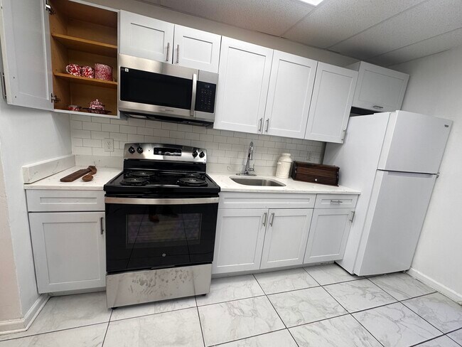
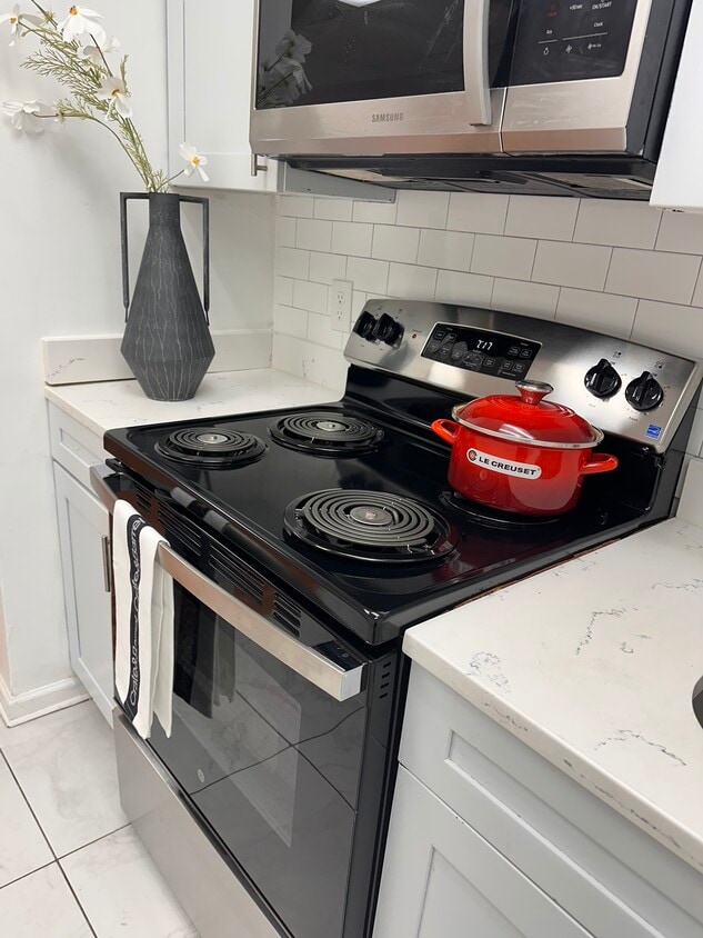
Cocina blanca impecable con estufa nueva y electrodomésticos modernos.
-
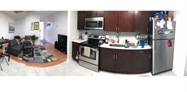
INSPIRACIÓN VIRTUAL PARA LA DECORACIÓN DEL PISO, BASADA EN EL INQUILINO ANTERIOR.
-
-
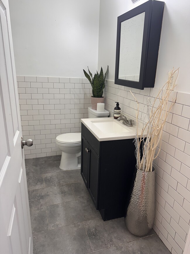
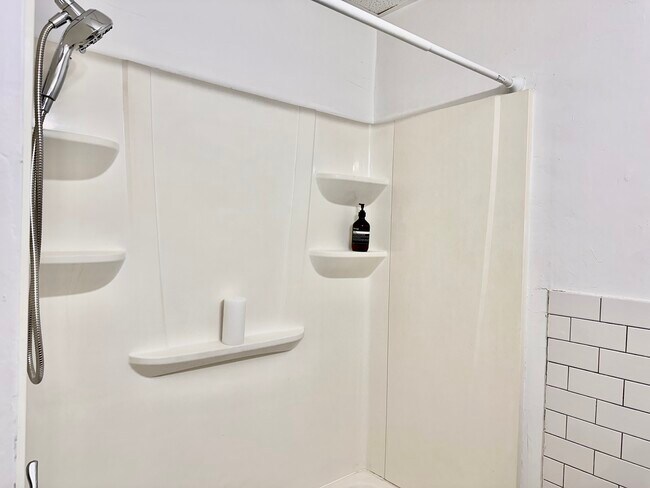
Baño reformado: estética limpia y moderna.
-
Pasillo que conecta la sala de estar con el dormitorio.
-
Modernas ventanas de doble acristalamiento, amplio dormitorio, espacioso vestidor.
-
-
Does 353 High St Unit 4 have in-unit laundry?
While 353 High St Unit 4 does not provide in‑unit laundry, on‑site laundry facilities are available for shared resident use.
What utilities are included in rent at 353 High St Unit 4?
Select utilities are included in rent at 353 High St Unit 4, including trash removal and air conditioning. Residents are responsible for any other utilities not listed.
Is parking available at 353 High St Unit 4?
Parking is available at 353 High St Unit 4. Fees may apply depending on the type of parking offered. Contact this property for details.
Which floor plans are available, and what are the price ranges?
353 High St Unit 4 has one-bedroom apartments renting for $1,499/mo.
Is 353 High St Unit 4 pet-friendly?
353 High St Unit 4 does not allow pets, though service animals are always welcome in accordance with applicable laws.
How much income do I need to rent at 353 High St Unit 4?
A good rule of thumb is to spend no more than 30% of your gross income on rent. Based on the lowest available rent of $1,499 for a one-bedroom, you would need to earn about $59,960 per year to qualify. Want to double-check your budget? Calculate how much rent you can afford with our Rent Affordability Calculator.
Does 353 High St Unit 4 have move-in specials?
353 High St Unit 4 is not currently offering any rent specials. Check back soon, as promotions change frequently.
Does 353 High St Unit 4 offer Matterport 3D tours?
While 353 High St Unit 4 does not offer Matterport 3D tours, renters can request a tour directly through our online platform.
How do I access Social Services in New Jersey?
Statewide service is free, confidential, multilingual and always open. Three easy ways to reach Social Services in NJ: Dial 2-1-1; text your zip code to 898-211; or chat at https://www.nj211.org
353 High St
Burlington, NJ 08016
Property Manager Responded