

$3,400 / Month
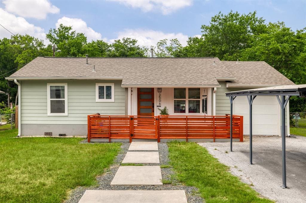
3506 Basford Rd
Austin, TX 78722
1 Day Ago
Favorites
512-820-4918
-
Bedrooms
3
-
Bathrooms
2
-
Square Feet
1,320 sq ft
-
Available
Available Now
3506 Basford Rd

Favorites
About This Home
Available Now
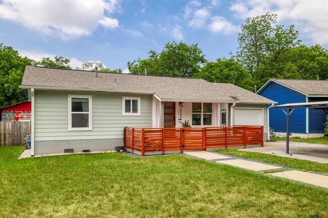
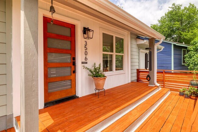
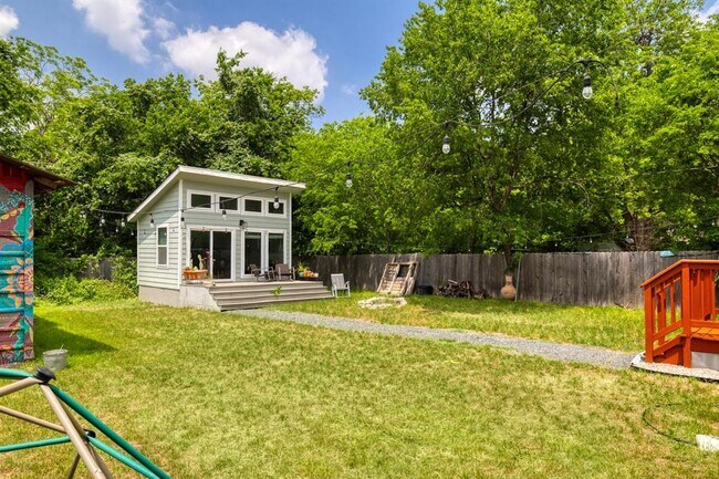
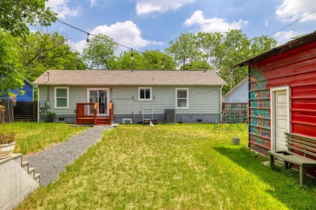
Wonderfully updated mid-century ranch in one of Cherrywood's charming tree lined pocket neighborhoods." Double size lot has separate office/workout studio with large porch at back of lot, big barn (543 square feet) that can be used for storage/projects. Home has had extensive cosmetic and functional updates so it lives and works like a new home. Includes covered parking (for sun and hail). Big covered front porch for hanging out and enjoying the street activity plus back deck off the ADU. All the great things about Manor Rd (Sixth Street for grown-ups) are a five minute walk down treed streets. All of Mueller conveniences three minutes away by car, minutes by foot. This is a unique property with great versatility at a terrific price point for Cherrywood -- perhaps the best family oriented neighborhood in central Austin."
3506 Basford Rd is a house located in Travis County and the 78722 ZIP Code. This area is served by the Austin Independent attendance zone.
* Price shown is base rent and may not include non-optional fees and utilities.
Price, availability, fees, and any applicable rent special are subject to change without notice.
* Square footage definitions vary. Displayed square footage is approximate.
Home Details
Home Type
Single Family Detached Home
Year Built
Built in 1950
Bedrooms and Bathrooms
3 Main Level Bedrooms
2 Full Bathrooms
Farming
Barn
Flooring
Tile
Laminate
Home Design
HardiePlank Type
Interior Spaces
Open Floorplan
1-Story Property
1,320 Sq Ft Home
Blinds
Kitchen
Free-Standing Gas Oven
Microwave
Dishwasher
Laundry
Washer and Dryer
Listing and Financial Details
Security Deposit $3,400
$60 Application Fee
Assessor Parcel Number 02141203350000
Tenant pays for all utilities
Lot Details
0.28 Acre Lot
East Facing Home
Back Yard Fenced
Outdoor Features
Deck
Covered patio or porch
Parking
Carport
1 Parking Space
Schools
Maplewood Elementary School
Kealing Middle School
Mccallum High School
Utilities
Central Heating and Cooling System
Community Details
Overview
No Home Owners Association
Giles Place Sec 02 Subdivision
Pet Policy
Dogs Allowed
Limit on the number of pets
Small pets allowed
Pet Deposit $250
Fees and Policies
The fees below are based on community-supplied data and may exclude additional fees and utilities.
- Dogs Allowed
-
Fees not specified
-
Weight limit--
-
Pet Limit--
Contact
- Listed by Adam Zell | Compass RE Texas, LLc
- Phone Number
- Contact
-
Source
 Austin Board of REALTORS®
The information included in this listing is provided exclusively for consumers’ personal, non-commercial use and may not be used for any purpose other than to identify prospective properties consumers may be interested in purchasing. The information on each listing is furnished by the owner and deemed reliable to the best of his/her knowledge, but should be verified by the purchaser. ABoR, ACTRIS and Estately assume no responsibility for typographical errors, misprints or misinformation. This property listing is offered without respect to any protected classes in accordance with the law. Copyright © 2025.
Location
Get Directions
Amenities
- Dishwasher
- Disposal
- Microwave
- Refrigerator
- Tile Floors
Also known as Cherrywood, Upper Boggy Creek is located in northeast Austin, adjacent to the University of Texas at Austin and directly east of Central Austin. Upper Boggy Creek is a wooded, private community with an abundance of ranch-style homes along quiet streets. It is a family-friendly neighborhood with good schools and plenty of parks. Upper Boggy Creek extends from Manor Road north to Airport Boulevard.
Just outside the neighborhood off Airport Boulevard, Mueller Lake Park provides a scenic lake with a fountain, an amphitheater, and a loop trail. Across from Mueller Lake Park and within Upper Boggy Creek, Patterson Neighborhood Park has a tennis center, a playground, a skate park, and a pool. Other parks include Willowbrook Reach and Cherrywood Pocket Park. In addition to great parks, Upper Boggy Creek offers great restaurants like Haymaker, Dai Due, Mi Madre’s, and Cherrywood Coffeehouse.
Learn more about living in Upper Boggy Creek
Education
| Colleges & Universities | Distance | ||
|---|---|---|---|
| Colleges & Universities | Distance | ||
| Drive: | 5 min | 1.7 mi | |
| Drive: | 5 min | 2.2 mi | |
| Drive: | 7 min | 3.6 mi | |
| Drive: | 9 min | 4.8 mi |
3506 Basford Rd is within 5 minutes or 1.7 miles from University of Texas at Austin. It is also near Austin C.C., Eastview Campus and Austin C.C., Rio Grande Campus.
Schools


Public Elementary School
Grades PK-5
402 Students
Attendance Zone
Public Middle School
Grades 6-8
1,255 Students
Attendance Zone
Public High School
Grades 9-12
1,824 Students
Attendance Zone
Private Elementary, Middle & High School
Grades 2-12
Nearby
Private Elementary, Middle & High School
Grades K-12
9 Students
Nearby
Private Elementary & Middle School
Grades PK-8
90 Students
Nearby
School data provided by
 The GreatSchools Rating helps parents compare schools within a state based on a variety of school quality indicators and provides a helpful picture of how effectively each school serves all of its students. Ratings are on a scale of 1 (below average) to 10 (above average) and can include test scores, college readiness, academic progress, advanced courses, equity, discipline and attendance data. We also advise parents to visit schools, consider other information on school performance and programs, and consider family needs as part of the school selection process.
View GreatSchools Rating Methodology
Data provided by GreatSchools.org © 2025. All rights reserved.
View GreatSchools Rating Methodology
Data provided by GreatSchools.org © 2025. All rights reserved.
Transportation options available in Austin include M L King Jr Station, located 1.2 miles from 3506 Basford Rd. 3506 Basford Rd is near Austin-Bergstrom International, located 11.0 miles or 21 minutes away.
| Transit / Subway | Distance | ||
|---|---|---|---|
| Transit / Subway | Distance | ||
| Drive: | 3 min | 1.2 mi | |
| Drive: | 6 min | 3.3 mi | |
| Drive: | 6 min | 3.3 mi | |
| Drive: | 7 min | 3.7 mi | |
| Drive: | 8 min | 4.3 mi |
| Commuter Rail | Distance | ||
|---|---|---|---|
| Commuter Rail | Distance | ||
|
|
Drive: | 10 min | 4.7 mi |
|
|
Drive: | 41 min | 33.8 mi |
|
|
Drive: | 43 min | 34.6 mi |
| Airports | Distance | ||
|---|---|---|---|
| Airports | Distance | ||
|
Austin-Bergstrom International
|
Drive: | 21 min | 11.0 mi |
Time and distance from 3506 Basford Rd.
| Shopping Centers | Distance | ||
|---|---|---|---|
| Shopping Centers | Distance | ||
| Walk: | 7 min | 0.4 mi | |
| Walk: | 10 min | 0.6 mi | |
| Walk: | 16 min | 0.8 mi |
3506 Basford Rd has 3 shopping centers within 0.8 mile, which is about a 16-minute walk. The miles and minutes will be for the farthest away property.
| Parks and Recreation | Distance | ||
|---|---|---|---|
| Parks and Recreation | Distance | ||
|
Thinkery
|
Drive: | 3 min | 1.2 mi |
|
Texas Memorial Museum
|
Drive: | 5 min | 1.8 mi |
|
Boggy Creek Greenbelt
|
Drive: | 5 min | 2.2 mi |
|
Elisabet Ney Museum
|
Drive: | 5 min | 2.4 mi |
|
Shoal Creek Greenbelt Park
|
Drive: | 8 min | 3.6 mi |
3506 Basford Rd has 5 parks within 3.6 miles, including Thinkery, Boggy Creek Greenbelt, and Texas Memorial Museum.
| Hospitals | Distance | ||
|---|---|---|---|
| Hospitals | Distance | ||
| Drive: | 3 min | 1.3 mi | |
| Drive: | 3 min | 1.4 mi | |
| Drive: | 3 min | 1.4 mi |
3506 Basford Rd has 3 hospitals within 1.4 miles, the nearest is Austin Lakes Hospital which is 1.3 miles away and a 3 minute drive.
| Military Bases | Distance | ||
|---|---|---|---|
| Military Bases | Distance | ||
| Drive: | 84 min | 68.8 mi | |
| Drive: | 89 min | 72.2 mi |
3506 Basford Rd is 68.8 miles from Randolph Air Force Base, and is convenient to other military bases, including Fort Cavazos.
You May Also Like
Similar Rentals Nearby


What Are Walk Score®, Transit Score®, and Bike Score® Ratings?
Walk Score® measures the walkability of any address. Transit Score® measures access to public transit. Bike Score® measures the bikeability of any address.
What is a Sound Score Rating?
A Sound Score Rating aggregates noise caused by vehicle traffic, airplane traffic and local sources
3506 Basford Rd
Austin, TX 78722