
-
3 Bedroom
-
-
-
$4,300
Total Monthly Price
35 Addington Rd
Brookline, MA 02445
2 Weeks Ago
|
Edit
Favorites
-
Bedrooms
3
-
Bathrooms
1
-
Square Feet
--
35 Addington Rd

Favorites
About This Home
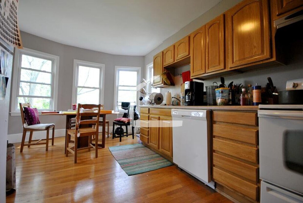
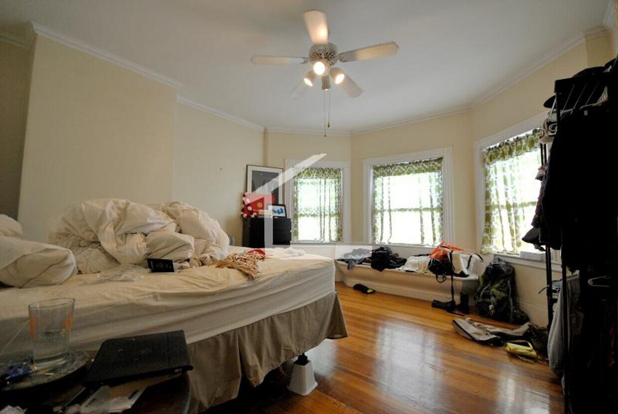
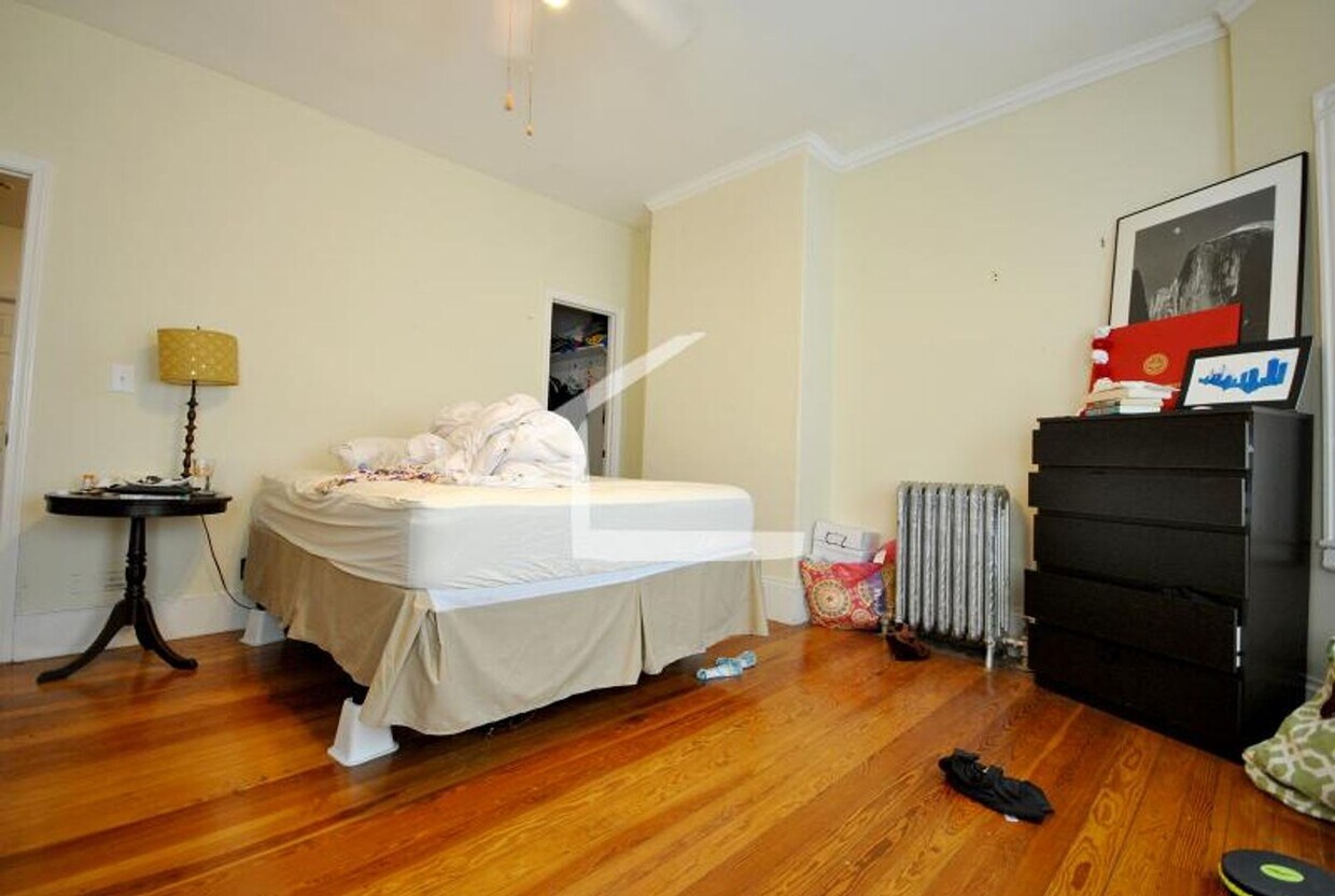
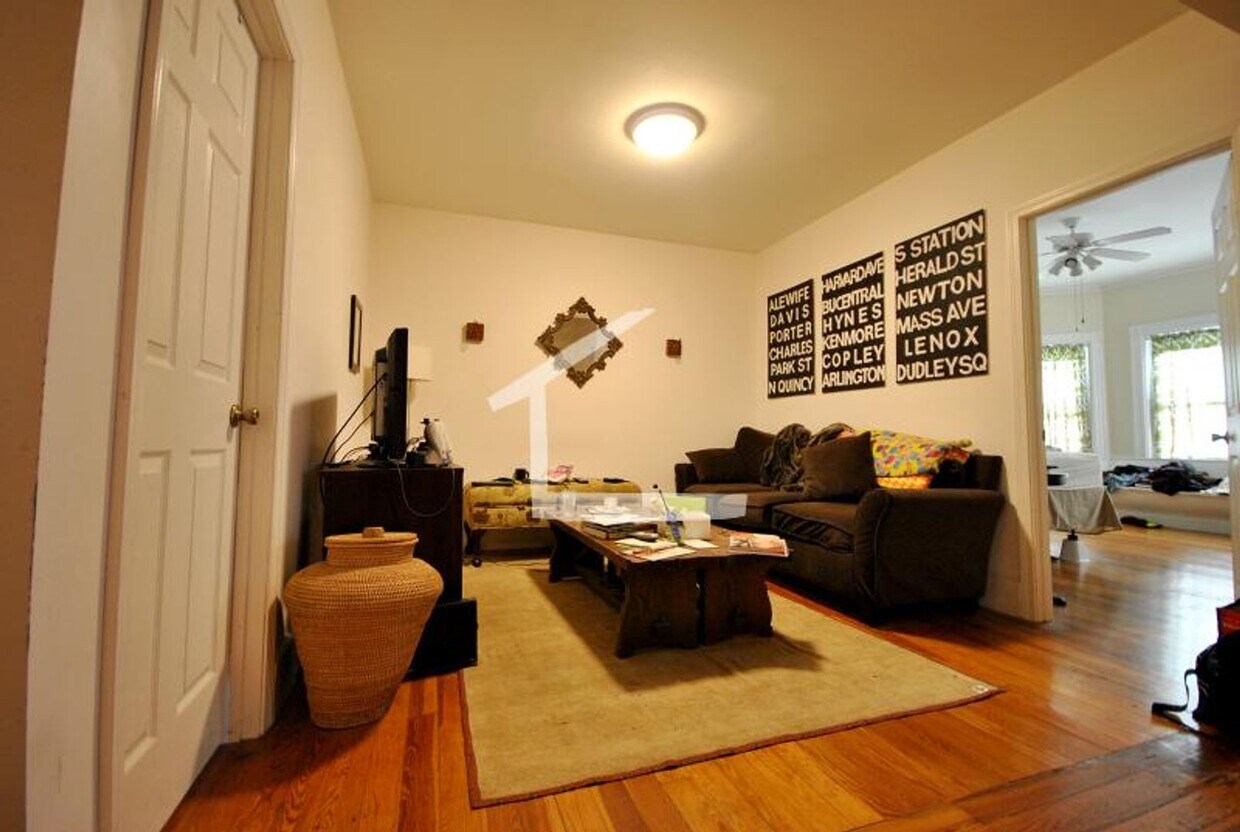
Introducing our charming 3-bedroom townhouse located in the heart of Brookline, MA. This cozy home features beautiful hardwood floors throughout, creating a warm and inviting atmosphere. With Boston University just a stone's throw away, convenience is at your fingertips. Say goodbye to the hassle of utility bills, as heat and hot water are included in your rent. Don't miss out on the opportunity to make this 3-bedroom townhouse your new home sweet home in Brookline. Contact us today for more information on our 2 Bedroom townhouse.
Unique Features
- Boston University
- heat and hot water included
- Hardwood floors
35 Addington Rd is a condo located in Norfolk County and the 02445 ZIP Code.
* Price shown is total price based on community-supplied monthly required fees. Excludes user-selected optional fees and variable or usage-based fees and required charges due at or prior to move-in or at move-out. Price, availability, fees, and any applicable rent special are subject to change without notice.
* Square footage definitions vary. Displayed square footage is approximate.
Contact
- Listed by Gateway Real Estate (AD) | Gateway Real Estate (AD)
Location
Get Directions
Washington Square’s charming, yet urban community delights residents – and it’s only seven miles from Downtown Boston. Beacon Street is where the action is, dotted with local and gourmet eateries, businesses, and coffee shops near Massachusetts Bay Transportation Authority light rail stations.
Corey Hill Outlook Park and Schick Park provide residents two great locations for outdoor recreational activities. Both are about equal distance from Washington Square Station and feature a playground. In addition to popular restaurants like the Publick House and La Voile, staff and students appreciate the short commute to Boston University.
Learn more about living in Washington Square
Amenities
- Boston University
- heat and hot water included
- Hardwood floors
Education
| Colleges & Universities | Distance | ||
|---|---|---|---|
| Colleges & Universities | Distance | ||
| Drive: | 6 min | 2.4 mi | |
| Drive: | 6 min | 2.7 mi | |
| Drive: | 6 min | 2.7 mi | |
| Drive: | 6 min | 2.7 mi |
35 Addington Rd is within 6 minutes or 2.7 miles from Boston University. It is also near Boston College, Brighton and Simmons College.
Transportation options available in Brookline include Tappan Street Station, located 0.4 mile from 35 Addington Rd. 35 Addington Rd is near General Edward Lawrence Logan International, located 8.5 miles or 19 minutes away.
| Transit / Subway | Distance | ||
|---|---|---|---|
| Transit / Subway | Distance | ||
|
|
Walk: | 7 min | 0.4 mi |
|
|
Walk: | 8 min | 0.4 mi |
|
|
Walk: | 9 min | 0.5 mi |
|
|
Walk: | 10 min | 0.5 mi |
|
|
Drive: | 3 min | 1.2 mi |
| Commuter Rail | Distance | ||
|---|---|---|---|
| Commuter Rail | Distance | ||
|
|
Drive: | 8 min | 3.0 mi |
|
|
Drive: | 10 min | 3.7 mi |
|
|
Drive: | 12 min | 4.2 mi |
|
|
Drive: | 9 min | 4.3 mi |
| Drive: | 12 min | 5.5 mi |
| Airports | Distance | ||
|---|---|---|---|
| Airports | Distance | ||
|
General Edward Lawrence Logan International
|
Drive: | 19 min | 8.5 mi |
Getting Around
 What do Walkability, Transit, Drivability, and Bikeability mean?
Walkability measures the walking distance to day-to-day needs.
Transit measures access to public transportation.
Drivability measures congestion, parking availability, and access to major roads.
Bikeability measures the suitability for cycling.
How It Works
What do Walkability, Transit, Drivability, and Bikeability mean?
Walkability measures the walking distance to day-to-day needs.
Transit measures access to public transportation.
Drivability measures congestion, parking availability, and access to major roads.
Bikeability measures the suitability for cycling.
How It Works
Exceptionally Walkable
Walkability
90
/ 100
Good Public Transit
Transit
60
/ 100
Fairly Drivable
Drivability
50
/ 100
Moderately Bikeable
Bikeability
70
/ 100
Scores provided by
-
Soundscore™
-
/ 100
Traffic
-Airport
-Businesses
-Scores provided by
HowLoud What is a Sound Score Rating? A Sound Score Rating aggregates noise caused by vehicle traffic, airplane traffic and local sources. How It WorksTime and distance from 35 Addington Rd.
| Shopping Centers | Distance | ||
|---|---|---|---|
| Shopping Centers | Distance | ||
| Walk: | 7 min | 0.4 mi | |
| Walk: | 14 min | 0.8 mi | |
| Drive: | 6 min | 2.2 mi |
35 Addington Rd has 3 shopping centers within 2.2 miles, which is about a 6-minute drive. The miles and minutes will be for the farthest away property.
| Parks and Recreation | Distance | ||
|---|---|---|---|
| Parks and Recreation | Distance | ||
|
Frederick Law Olmsted National Historic Site
|
Drive: | 4 min | 1.2 mi |
|
Chestnut Hill Reservation
|
Drive: | 3 min | 1.4 mi |
|
John Fitzgerald Kennedy National Historic Site
|
Drive: | 4 min | 1.6 mi |
|
Coit Observatory
|
Drive: | 7 min | 3.1 mi |
|
Charles River Reservation
|
Drive: | 8 min | 3.5 mi |
35 Addington Rd has 5 parks within 3.5 miles, including Frederick Law Olmsted National Historic Site, Chestnut Hill Reservation, and John Fitzgerald Kennedy National Historic Site.
| Hospitals | Distance | ||
|---|---|---|---|
| Hospitals | Distance | ||
| Drive: | 5 min | 1.7 mi | |
| Drive: | 5 min | 1.7 mi | |
| Drive: | 5 min | 2.0 mi |
35 Addington Rd has 3 hospitals within 2.0 miles, the nearest is Franciscan Children's Hospital & Rehab Center which is 1.7 miles away and a 5 minute drive.
| Military Bases | Distance | ||
|---|---|---|---|
| Military Bases | Distance | ||
| Drive: | 25 min | 14.0 mi | |
| Drive: | 31 min | 15.0 mi |
35 Addington Rd is 14.0 miles from US Military Reservation, and is convenient to other military bases, including Hanscom Air Force Base.
You May Also Like
Similar Rentals Nearby
-
-

-
 4 Beds$6,500Total Monthly Price12 Month LeaseTotal Monthly Price NewPrices include all required monthly fees.Condo for Rent
 -

-

-

-
-

-

-


What Are Walk Score®, Transit Score®, and Bike Score® Ratings?
Walk Score® measures the walkability of any address. Transit Score® measures access to public transit. Bike Score® measures the bikeability of any address.
What is a Sound Score Rating?
A Sound Score Rating aggregates noise caused by vehicle traffic, airplane traffic and local sources.

35 Addington Rd
Brookline, MA 02445