

$1,500 / Month
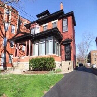
3432 Telford St
Cincinnati, OH 45220
2 Weeks Ago
Favorites
3432 Telford St

Favorites
Check Back Soon for Upcoming Availability
| Beds | Baths | Average SF |
|---|---|---|
| 2 Bedrooms 2 Bedrooms 2 Br | 1 Bath 1 Bath 1 Ba | 1,500 SF |
Fees and Policies
The fees below are based on community-supplied data and may exclude additional fees and utilities.
- Dogs Allowed
-
Fees not specified
-
Weight limit--
-
Pet Limit--
Details
Utilities Included
-
Water
-
Trash Removal
-
Sewer
About This Property
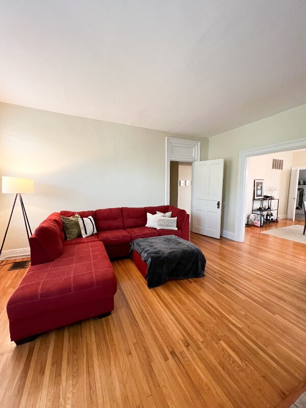
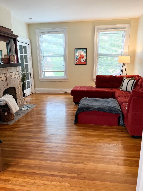
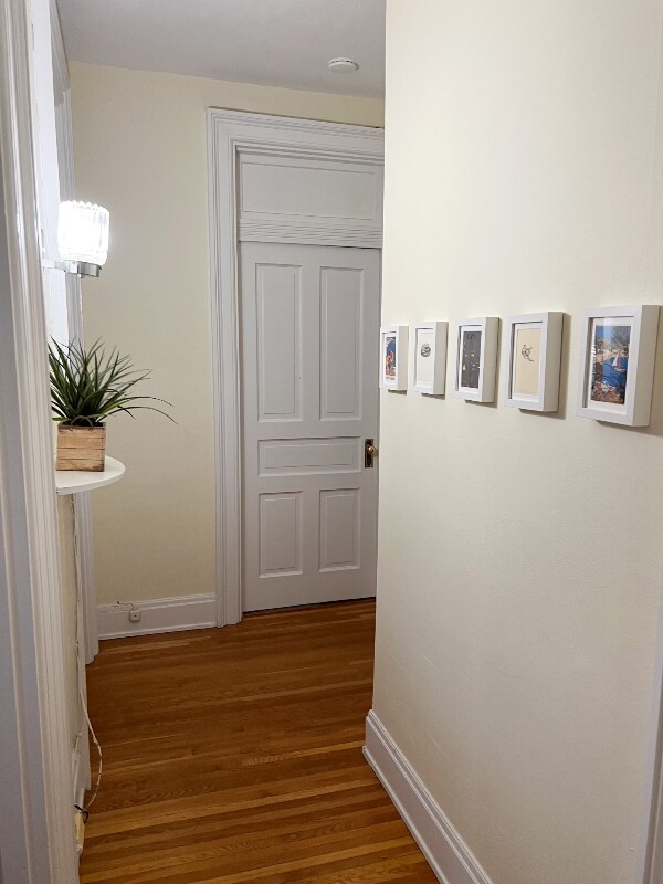
Property Id: 386622 Recently updated Spacious light filed 2nd floor apartment on a quiet street. Walking distance to the University of Cincinnati. Apartment features: Hardwood floors, Two fireplaces, Large rooms, Tall ceilings, and one off street parking spot. On-Site laundry facilities.
3432 Telford St is a house located in Hamilton County and the 45220 ZIP Code. This area is served by the Cincinnati Public Schools attendance zone.
House Features
Dishwasher
Hardwood Floors
Microwave
Refrigerator
- Cable Ready
- Fireplace
- Dishwasher
- Microwave
- Oven
- Refrigerator
- Hardwood Floors
- Tile Floors
- Lawn
Location
Get Directions
In Clifton there’s plenty to do and see. The rolling hills, lush parks and green spaces, hip shopping, and affordable apartments create a vibrancy in Clifton that can’t be ignored.
In addition to its active art scene, the neighborhood is encompassing of Mount Storm Park, Edgewood Grove Park, and the Cincinnati State Technical and Community College. Locals enjoy the direct access to Interstate 75, making commutes in and around the city a breeze.
Clifton is just north of the 90-acre Burnet Woods Park and the University of Cincinnati campus. When you have a craving for something sweet or savory, head on over to the Clifton Gaslight District for every kind of cuisine imaginable. Clifton sits atop a hill overlooking the Northside, and Ludlow Avenue has been dubbed Cincinnati’s first “Main Street.
Learn more about living in CliftonBelow are rent ranges for similar nearby apartments
| Beds | Average Size | Lowest | Typical | Premium |
|---|---|---|---|---|
| Studio Studio Studio | 472-476 Sq Ft | $695 | $1,038 | $1,479 |
| 1 Bed 1 Bed 1 Bed | 672-673 Sq Ft | $720 | $1,138 | $3,960 |
| 2 Beds 2 Beds 2 Beds | 997-999 Sq Ft | $895 | $1,599 | $4,350 |
| 3 Beds 3 Beds 3 Beds | 1190-1198 Sq Ft | $899 | $1,709 | $7,500 |
| 4 Beds 4 Beds 4 Beds | 1590-1594 Sq Ft | $575 | $1,832 | $29,390 |
Amenities
- Cable Ready
- Fireplace
- Dishwasher
- Microwave
- Oven
- Refrigerator
- Hardwood Floors
- Tile Floors
- Lawn
Expenses
Utilities Included
Water, Trash Removal, Sewer
Included
Education
| Colleges & Universities | Distance | ||
|---|---|---|---|
| Colleges & Universities | Distance | ||
| Drive: | 3 min | 1.4 mi | |
| Drive: | 5 min | 1.5 mi | |
| Drive: | 7 min | 1.8 mi | |
| Drive: | 9 min | 3.2 mi |
3432 Telford St is within 3 minutes or 1.4 miles from University of Cincinnati. It is also near Cincinnati State and Univ. of Cincinnati, Medical.
Schools


Public Elementary & Middle School
Grades K-7 & 9
680 Students
Nearby
Public Elementary, Middle & High School
Grades 5-12
2,582 Students
Attendance Zone
Public Middle & High School
Grades 7-12
1,155 Students
Attendance Zone
Private Elementary & Middle School
Grades PK-8
183 Students
Nearby
Private High School
Grades 9-12
486 Students
Nearby
School data provided by
 The GreatSchools Rating helps parents compare schools within a state based on a variety of school quality indicators and provides a helpful picture of how effectively each school serves all of its students. Ratings are on a scale of 1 (below average) to 10 (above average) and can include test scores, college readiness, academic progress, advanced courses, equity, discipline and attendance data. We also advise parents to visit schools, consider other information on school performance and programs, and consider family needs as part of the school selection process.
View GreatSchools Rating Methodology
Data provided by GreatSchools.org © 2025. All rights reserved.
View GreatSchools Rating Methodology
Data provided by GreatSchools.org © 2025. All rights reserved.
Transportation options available in Cincinnati include Findlay Market-Race Station, Race & Elder, located 2.4 miles from 3432 Telford St. 3432 Telford St is near Cincinnati/Northern Kentucky International, located 17.9 miles or 32 minutes away.
| Transit / Subway | Distance | ||
|---|---|---|---|
| Transit / Subway | Distance | ||
| Drive: | 6 min | 2.4 mi | |
| Drive: | 6 min | 2.5 mi | |
| Drive: | 7 min | 2.5 mi | |
| Drive: | 7 min | 2.6 mi | |
| Drive: | 8 min | 2.9 mi |
| Commuter Rail | Distance | ||
|---|---|---|---|
| Commuter Rail | Distance | ||
|
|
Drive: | 8 min | 3.9 mi |
| Airports | Distance | ||
|---|---|---|---|
| Airports | Distance | ||
|
Cincinnati/Northern Kentucky International
|
Drive: | 32 min | 17.9 mi |
Time and distance from 3432 Telford St.
| Shopping Centers | Distance | ||
|---|---|---|---|
| Shopping Centers | Distance | ||
| Drive: | 3 min | 1.2 mi | |
| Drive: | 4 min | 1.6 mi | |
| Drive: | 6 min | 2.5 mi |
3432 Telford St has 3 shopping centers within 2.5 miles, which is about a 6-minute drive. The miles and minutes will be for the farthest away property.
| Parks and Recreation | Distance | ||
|---|---|---|---|
| Parks and Recreation | Distance | ||
|
Burnet Woods
|
Walk: | 8 min | 0.4 mi |
|
Cincinnati Zoo and Botanical Garden
|
Walk: | 15 min | 0.8 mi |
|
Trailside Nature Center
|
Drive: | 3 min | 1.3 mi |
|
William H. Taft National Historic Site
|
Drive: | 7 min | 2.6 mi |
|
Buttercup Valley
|
Drive: | 8 min | 3.0 mi |
3432 Telford St has 5 parks within 3.0 miles, including Burnet Woods, Trailside Nature Center, and Cincinnati Zoo and Botanical Garden.
| Hospitals | Distance | ||
|---|---|---|---|
| Hospitals | Distance | ||
| Walk: | 9 min | 0.5 mi | |
| Drive: | 5 min | 1.4 mi | |
| Drive: | 5 min | 1.9 mi |
3432 Telford St has 3 hospitals within 1.9 miles, the nearest is Good Samaritan Hospital which is 0.5 mile away and a 9 minute walk.
| Military Bases | Distance | ||
|---|---|---|---|
| Military Bases | Distance | ||
| Drive: | 67 min | 51.0 mi | |
| Drive: | 73 min | 56.0 mi | |
| Drive: | 76 min | 59.3 mi |
3432 Telford St has 3 military bases within 59.3 miles, the nearest is Gentile Air Force Station which is 51.0 miles away and a 67 minute drive.
You May Also Like
Similar Rentals Nearby


What Are Walk Score®, Transit Score®, and Bike Score® Ratings?
Walk Score® measures the walkability of any address. Transit Score® measures access to public transit. Bike Score® measures the bikeability of any address.
What is a Sound Score Rating?
A Sound Score Rating aggregates noise caused by vehicle traffic, airplane traffic and local sources

3432 Telford St
Cincinnati, OH 45220