$2,300 / Month
338 S Pomelo Ave
Monterey Park, CA 91755
2 Weeks Ago
Favorites
338 S Pomelo Ave

Favorites
Check Back Soon for Upcoming Availability
| Beds | Baths | Average SF |
|---|---|---|
| 2 Bedrooms 2 Bedrooms 2 Br | 1 Bath 1 Bath 1 Ba | 1,000 SF |
Fees and Policies
The fees below are based on community-supplied data and may exclude additional fees and utilities.
Details
Utilities Included
-
Trash Removal
About This Property
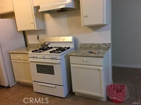
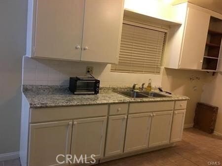
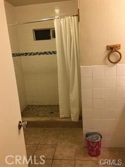
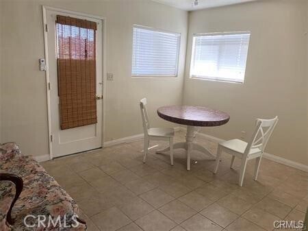
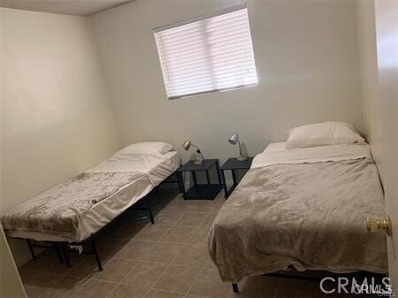
Property located in a desirable area of Monterey Park. This unit has an open floor plan with 2 bedroom and 1 bathroom with dining area, and laundry area. Property includes tile floor throughout the house, remodeled bathroom. The house sits in a quiet neighborhood, minutes away from Supermarkets, Post Office, Mark Keppel High School, Two parking spaces will be provide inside the parking lot. No pets please and unit is max of three occupants only.
338 S Pomelo Ave is an apartment community located in Los Angeles County and the 91755 ZIP Code.
Features
- Air Conditioning
- Heating
Location
Get Directions
Garvey is a predominantly residential neighborhood located in the heart of San Gabriel Valley. Complemented by cacti and palm trees, a variety of moderately-priced to upscale Mediterranean-style houses, and apartments dot the neighborhood. Garvey has several schools, parks, stores, authentic restaurants, and international grocery stores. Residents enjoy access to several roadways including Interstate 710, Interstate 10, and Highway 60. Downtown Los Angeles, which is just 10 miles away, and other major destinations are convenient to Garvey. If you’re looking for a family-oriented neighborhood or a quiet place convenient for commuting, Garvey is a great choice.
Learn more about living in GarveyBelow are rent ranges for similar nearby apartments
Amenities
- Air Conditioning
- Heating
Expenses
Utilities Included
Trash Removal
Included
Education
| Colleges & Universities | Distance | ||
|---|---|---|---|
| Colleges & Universities | Distance | ||
| Drive: | 8 min | 3.5 mi | |
| Drive: | 10 min | 5.3 mi | |
| Drive: | 13 min | 6.8 mi | |
| Drive: | 15 min | 7.3 mi |
338 S Pomelo Ave is within 8 minutes or 3.5 miles from East Los Angeles College. It is also near Cal State Los Angeles and Art Center College of Design.
Transportation options available in Monterey Park include Atlantic Station, located 3.8 miles from 338 S Pomelo Ave. 338 S Pomelo Ave is near Bob Hope, located 23.9 miles or 33 minutes away, and Long Beach (Daugherty Field), located 24.3 miles or 35 minutes away.
| Transit / Subway | Distance | ||
|---|---|---|---|
| Transit / Subway | Distance | ||
| Drive: | 9 min | 3.8 mi | |
| Drive: | 9 min | 4.2 mi | |
| Drive: | 11 min | 4.7 mi | |
| Drive: | 11 min | 6.6 mi | |
| Drive: | 14 min | 6.9 mi |
| Commuter Rail | Distance | ||
|---|---|---|---|
| Commuter Rail | Distance | ||
| Drive: | 11 min | 5.1 mi | |
|
|
Drive: | 10 min | 5.9 mi |
|
|
Drive: | 16 min | 6.8 mi |
|
|
Drive: | 13 min | 9.1 mi |
| Drive: | 17 min | 13.2 mi |
| Airports | Distance | ||
|---|---|---|---|
| Airports | Distance | ||
|
Bob Hope
|
Drive: | 33 min | 23.9 mi |
|
Long Beach (Daugherty Field)
|
Drive: | 35 min | 24.3 mi |
Time and distance from 338 S Pomelo Ave.
| Shopping Centers | Distance | ||
|---|---|---|---|
| Shopping Centers | Distance | ||
| Walk: | 11 min | 0.6 mi | |
| Walk: | 14 min | 0.8 mi | |
| Walk: | 17 min | 0.9 mi |
338 S Pomelo Ave has 3 shopping centers within 0.9 mile, which is about a 17-minute walk. The miles and minutes will be for the farthest away property.
| Parks and Recreation | Distance | ||
|---|---|---|---|
| Parks and Recreation | Distance | ||
|
Whittier Narrows Recreation Area
|
Drive: | 12 min | 4.4 mi |
|
Whittier Narrows Nature Center
|
Drive: | 11 min | 5.7 mi |
|
Huntington Botanical Gardens
|
Drive: | 17 min | 6.0 mi |
|
Pio Pico State Historic Park
|
Drive: | 15 min | 6.7 mi |
|
Audubon Center at Debs Park
|
Drive: | 17 min | 11.4 mi |
338 S Pomelo Ave has 5 parks within 11.4 miles, including Whittier Narrows Recreation Area, Whittier Narrows Nature Center, and Huntington Botanical Gardens.
| Hospitals | Distance | ||
|---|---|---|---|
| Hospitals | Distance | ||
| Drive: | 4 min | 1.4 mi | |
| Drive: | 5 min | 2.2 mi | |
| Drive: | 8 min | 4.4 mi |
338 S Pomelo Ave has 3 hospitals within 4.4 miles, the nearest is Garfield Medical Center which is 1.4 miles away and a 4 minute drive.
| Military Bases | Distance | ||
|---|---|---|---|
| Military Bases | Distance | ||
| Drive: | 39 min | 25.8 mi | |
| Drive: | 36 min | 26.9 mi |
338 S Pomelo Ave is 25.8 miles from Los Alamitos Army Airfield, and is convenient to other military bases, including Los Angeles Air Force Base.
You May Also Like
Similar Rentals Nearby


What Are Walk Score®, Transit Score®, and Bike Score® Ratings?
Walk Score® measures the walkability of any address. Transit Score® measures access to public transit. Bike Score® measures the bikeability of any address.
What is a Sound Score Rating?
A Sound Score Rating aggregates noise caused by vehicle traffic, airplane traffic and local sources

338 S Pomelo Ave
Monterey Park, CA 91755