$1,550
Total Monthly Price
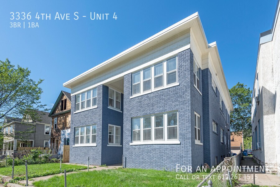
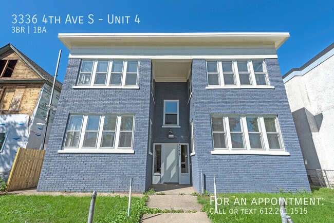
3336 4th Ave S Unit 4
Minneapolis, MN 55408
Favorites
-
Bedrooms
3
-
Bathrooms
1
-
Square Feet
1,100 sq ft
3336 4th Ave S Unit 4

Favorites
About This Home
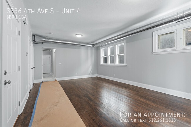
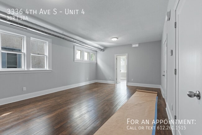
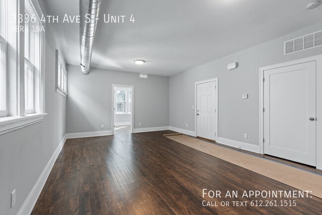
Laundry, 3 bedrooms apartment, S Minneapolis! Gorgeous 3 bedroom, 1 bath unit in a low-rise building, located in South Minneapolis close to the city center. Convenient location with easy access to the amenities of the greater Minneapolis-St. Paul. Residents can enjoy walking paths at Powderhorn Park, a 66-acre spread providing picnic facilities, a fishing pier, and athletic fields. Unit has gleaming hardwood floors, stainless steel appliances. Pet friendly. Shared Washer/Dryer in the basement. Tenants pay Electric, Gas, + % Water/sewer/Trash (depending how many people) TO SCHEDULE SHOWINGS, copy/paste link to your browser: 3D Tour available as well (unit 3&4 floor plans are mirror images) Rental criteria: Household rent to income ratio=35% No felonies within 7 years No evictions within 2 years Must view unit in person No history of missed payments/Delinquent Debts Application fee is $70 per person/nonrefundable Max tenants= 5 A co-signer may be required if applicant has no rental history or rental reference Tenants pay Electric, Gas, + % Water/sewer/Trash (depending how many people) Owner does Snow/Lawn care Pet fee: 1 dog $30mon, or 1 cat $25/month. All pets must go through pet
3336 4th Ave S is an apartment community located in Hennepin County and the 55408 ZIP Code.
* Price shown is total price based on community-supplied monthly required fees. Excludes user-selected optional fees and variable or usage-based fees and required charges due at or prior to move-in or at move-out. Price, availability, fees, and any applicable rent special are subject to change without notice.
* Square footage definitions vary. Displayed square footage is approximate.
Contact
- Listed by Jeremy Pekarek
Location
Get Directions
Characterized by single-family homes and low-rise multi-family rentals along tree-lined streets, the Central neighborhood of Minneapolis lies about three miles due south of the city center. Bordered on the west by I-35, the Central area provides its residents with a convenient location and easy access to the amenities of the greater Minneapolis-St. Paul region.
Stroll well-kept sidewalks or the walking paths at Powderhorn Park, a 66-acre spread providing picnic facilities, an ice skating rink, a fishing pier, and athletic fields. For a change of pace, visit Central Gym Park on the neighborhood's south side to play tennis or shoot hoops indoors. Then drop into the highly popular Café South Side for a soup and sandwich, a fresh-baked pastry, or a cup of coffee brewed from organic beans.
Learn more about living in Central
Education
| Colleges & Universities | Distance | ||
|---|---|---|---|
| Colleges & Universities | Distance | ||
| Drive: | 6 min | 2.9 mi | |
| Drive: | 6 min | 3.0 mi | |
| Drive: | 7 min | 3.3 mi | |
| Drive: | 8 min | 4.1 mi |
3336 4th Ave S Unit 4 is within 6 minutes or 2.9 miles from North Central University. It is also near University of St. Thomas and Minneapolis College.
Transportation options available in Minneapolis include Lake Street/Midtown Station, located 2.1 miles from 3336 4th Ave S Unit 4. 3336 4th Ave S Unit 4 is near Minneapolis-St Paul International/Wold-Chamberlain, located 10.4 miles or 19 minutes away.
| Transit / Subway | Distance | ||
|---|---|---|---|
| Transit / Subway | Distance | ||
|
|
Drive: | 6 min | 2.1 mi |
|
|
Drive: | 8 min | 2.5 mi |
|
|
Drive: | 7 min | 2.7 mi |
| Drive: | 8 min | 3.4 mi | |
|
|
Drive: | 8 min | 4.0 mi |
| Commuter Rail | Distance | ||
|---|---|---|---|
| Commuter Rail | Distance | ||
|
|
Drive: | 9 min | 3.9 mi |
|
|
Drive: | 18 min | 11.9 mi |
|
|
Drive: | 18 min | 12.0 mi |
|
|
Drive: | 32 min | 23.0 mi |
|
|
Drive: | 34 min | 24.7 mi |
| Airports | Distance | ||
|---|---|---|---|
| Airports | Distance | ||
|
Minneapolis-St Paul International/Wold-Chamberlain
|
Drive: | 19 min | 10.4 mi |
Getting Around
 What do Walkability, Transit, Drivability, and Bikeability mean?
Walkability measures the walking distance to day-to-day needs.
Transit measures access to public transportation.
Drivability measures congestion, parking availability, and access to major roads.
Bikeability measures the suitability for cycling.
How It Works
What do Walkability, Transit, Drivability, and Bikeability mean?
Walkability measures the walking distance to day-to-day needs.
Transit measures access to public transportation.
Drivability measures congestion, parking availability, and access to major roads.
Bikeability measures the suitability for cycling.
How It Works
Very Walkable
Walkability
80
/ 100
Strong Public Transit
Transit
80
/ 100
Moderately Drivable
Drivability
70
/ 100
Moderately Bikeable
Bikeability
70
/ 100
Scores provided by
-
Soundscore™
-
/ 100
Traffic
-Airport
-Businesses
-Scores provided by
HowLoud What is a Sound Score Rating? A Sound Score Rating aggregates noise caused by vehicle traffic, airplane traffic and local sources. How It WorksTime and distance from 3336 4th Ave S Unit 4.
| Shopping Centers | Distance | ||
|---|---|---|---|
| Shopping Centers | Distance | ||
| Walk: | 13 min | 0.7 mi | |
| Drive: | 3 min | 1.1 mi | |
| Drive: | 6 min | 1.7 mi |
3336 4th Ave S Unit 4 has 3 shopping centers within 1.7 miles, which is about a 6-minute drive. The miles and minutes will be for the farthest away property.
| Parks and Recreation | Distance | ||
|---|---|---|---|
| Parks and Recreation | Distance | ||
|
Painter Park
|
Walk: | 21 min | 1.1 mi |
|
Powderhorn Park
|
Drive: | 4 min | 1.1 mi |
|
Rev. Dr. Martin Luther King Jr. Park
|
Drive: | 4 min | 1.3 mi |
|
Bryant Square Park
|
Drive: | 4 min | 1.4 mi |
|
Phelps Park
|
Drive: | 4 min | 1.4 mi |
3336 4th Ave S Unit 4 has 5 parks within 1.4 miles, including Phelps Park, Powderhorn Park, and Painter Park.
| Hospitals | Distance | ||
|---|---|---|---|
| Hospitals | Distance | ||
| Drive: | 3 min | 1.2 mi | |
| Drive: | 4 min | 1.5 mi | |
| Drive: | 7 min | 3.1 mi |
3336 4th Ave S Unit 4 has 3 hospitals within 3.1 miles, the nearest is Abbott Northwestern Hospital which is 1.2 miles away and a 3 minute drive.
| Military Bases | Distance | ||
|---|---|---|---|
| Military Bases | Distance | ||
| Drive: | 15 min | 8.2 mi |
3336 4th Ave S Unit 4 is 8.2 miles and a 15 minute drive from Fort Snelling Military Reservation.
You May Also Like
-
CURRENTS
3205 Harbor Ln N
Plymouth, MN 55447
$2,900 - $2,950 Plus Fees
3 Br 13 Month Lease 10.8 mi
-
Quinn at Plymouth
6110 Quinwood Ln N
Plymouth, MN 55442
$2,295 - $2,395 Plus Fees
3 Br 12 Month Lease 11.8 mi
-
The Overlook at Crystal Lake
15315 Maple Island Rd
Burnsville, MN 55306
$2,595 Total Monthly Price
3 Br 12 Month Lease 15.0 mi
Similar Rentals Nearby
-
-
-
3 Beds$5,884Total Monthly PriceTotal Monthly Price NewPrices include required monthly fees of $4.Base Rent:3 Beds$5,880+1 Month Free
Pets Allowed Fitness Center Pool Dishwasher Refrigerator Clubhouse Maintenance on site
-
3 Beds$1,921Total Monthly PriceTotal Monthly Price NewPrices include required monthly fees of $22.Base Rent:3 Beds$1,899
Pool
-
Plus Fees3 Beds$3,570+1 Month Free
Pets Allowed Fitness Center Pool Dishwasher Refrigerator Kitchen
-
-
3 Beds$3,009+Total Monthly PriceTotal Monthly Price NewPrices include base rent and required monthly fees of $83. Variable costs based on usage may apply.Base Rent:3 Beds$2,925+Specials
Pets Allowed Fitness Center Pool In Unit Washer & Dryer Business Center Package Service
-
-
3 Beds$2,648+Total Monthly PriceTotal Monthly Price NewPrices include base rent and required monthly fees of $23. Variable costs based on usage may apply.Base Rent:3 Beds$2,625+1 Month Free
Pets Allowed Fitness Center Pool Maintenance on site Stainless Steel Appliances Business Center
-
3 Beds$1,669+Total Monthly PriceTotal Monthly Price NewPrices include required monthly fees of $25 - $50.Base Rent:3 Beds$1,644+Specials
Pets Allowed Fitness Center Dishwasher Refrigerator Kitchen In Unit Washer & Dryer


What Are Walk Score®, Transit Score®, and Bike Score® Ratings?
Walk Score® measures the walkability of any address. Transit Score® measures access to public transit. Bike Score® measures the bikeability of any address.
What is a Sound Score Rating?
A Sound Score Rating aggregates noise caused by vehicle traffic, airplane traffic and local sources.

3336 4th Ave S
Minneapolis, MN 55408