

$2,600
Total Monthly Price
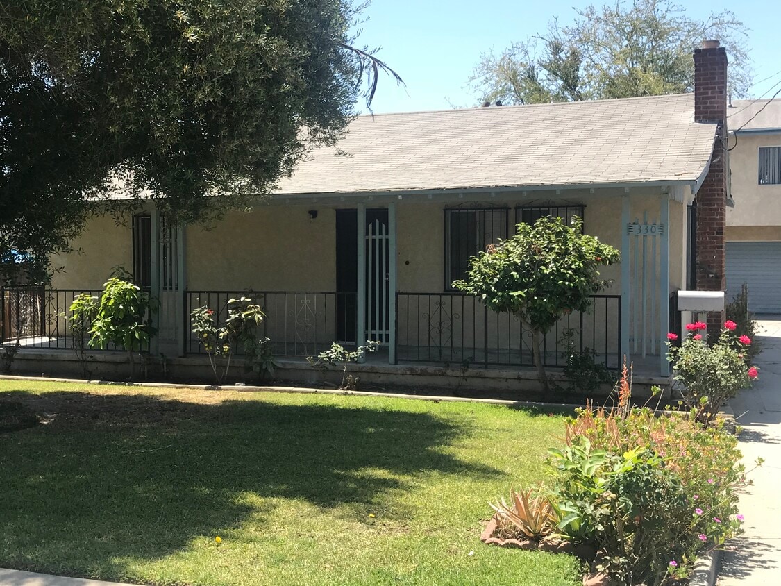
330 W Bencamp St Unit A
San Gabriel, CA 91776
2 Days Ago
|
Edit
Favorites
626-828-6675
-
Bedrooms
2
-
Bathrooms
1
-
Square Feet
1,100 sq ft
-
Available
Available Apr 1
330 W Bencamp St Unit A

Favorites
About This Home
12 Month Lease,
$2,600 deposit,
Available Apr 1
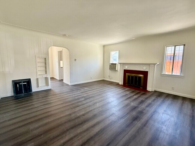
JUST RENOVATED WITH NEW FLOORS, NEW PAINT, and NEW FRIDGE! GREAT LOCATION IN WALKING DISTANCE TO PARKS, DINING & SHOPPING ON VALLEY BLVD, and 99 RANCH MARKET PLAZA. GOOD SCHOOLS IN SAN GABRIEL UNIFIED SCHOOL DISTRICT (10/10 for Gabrielino High School on GreatSchools). 2 BD / 1 BA SINGLE-FAMILY, STAND-ALONE RESIDENCE FOR PRIVACY ON A TRIPLEX PROPERTY. QUIET and SAFE NEIGHBORHOOD. 2 blocks to 99 Ranch Market Plaza, shopping, dining, parks, and schools. Parking available in back and on street. Quick and convenient freeway access. Owner pays trash, sewer and gardening. Tenant pays gas and electricity (separately metered) and per person share of water.
RECENTLY RENOVATED! GREAT LOCATION! 2 BD / 1 BA HOUSE WITH NEW BATHROOM AND NEW FLOORS ON A TRIPLEX PROPERTY! QUIET AND SAFE neighborhood with PRIVACY and SAN GABRIEL SCHOOLS. Walking distance to 99 Ranch Market / Focus Plaza, Valley Blvd restaurants and shopping, and brand new Marshall Community Park. A/C units in living room and bedroom. Two (2) tandem parking spaces available in driveway. Quick and convenient freeway access. Owner pays trash, sewer and gardening. Tenant pays per person share of water and gas and electricity (separately metered).
330 W Bencamp St is a condo located in Los Angeles County and the 91776 ZIP Code. This area is served by the San Gabriel Unified School District attendance zone.
* Price shown is total price based on community-supplied monthly required fees. Excludes user-selected optional fees and variable or usage-based fees and required charges due at or prior to move-in or at move-out. Price, availability, fees, and any applicable rent special are subject to change without notice.
* Square footage definitions vary. Displayed square footage is approximate.
Condo Features
- Washer/Dryer Hookup
- Air Conditioning
- Refrigerator
- Storage Space
Fees and Policies
The fees listed below are community-provided and may exclude utilities or add-ons. All payments are made directly to the property and are non-refundable unless otherwise specified.
- Parking
-
Surface Lot--
Details
Utilities Included
-
Trash Removal
-
Sewer
Lease Options
-
12 Months
Contact
- Listed by Jason P
- Phone Number
- Contact
Location
Get Directions
Situated about ten miles northeast of Los Angeles, San Gabriel is a scenic suburb often regarded as the “Birthplace of the Los Angeles Region.” The city boasts a rich history dating back to the 1700s, when the Mission San Gabriel (known as the “Pride of the California Missions”) was founded.
San Gabriel’s historic roots are on display to this day, with the vibrant Mission District serving as the city’s hub of culture, art, and history. City Hall, the San Gabriel Mission Playhouse, and numerous well-maintained Spanish Colonial Revival style buildings are the cornerstones of the District. A host of diverse eateries, cafes, offices, shops, and museums—including the famed San Gabriel Mission—are also found in this vibrant downtown area.
Area residents enjoy a bevy of outdoor activities at Vincent Lugo Park, Smith Park, and San Gabriel Country Club.
Learn more about living in San Gabriel
Education
| Colleges & Universities | Distance | ||
|---|---|---|---|
| Colleges & Universities | Distance | ||
| Drive: | 9 min | 4.6 mi | |
| Drive: | 10 min | 5.2 mi | |
| Drive: | 13 min | 5.3 mi | |
| Drive: | 15 min | 5.4 mi |
330 W Bencamp St Unit A is within 9 minutes or 4.6 miles from Cal State Los Angeles. It is also near East Los Angeles College and Caltech.
Schools


Public Elementary School
Grades K-5
Nearby
Public Elementary School
Grades K-5
Attendance Zone
Public Middle School
Grades 6-8
Attendance Zone
Public High School
Grades 9-12
Attendance Zone
Private Elementary, Middle & High School
Grades K-12
Nearby
Private Elementary & Middle School
Grades PK-8
Nearby
School data provided by
 The GreatSchools Rating helps parents compare schools within a state based on a variety of school quality indicators and provides a helpful picture of how effectively each school serves all of its students. Ratings are on a scale of 1 (below average) to 10 (above average) and can include test scores, college readiness, academic progress, advanced courses, equity, discipline and attendance data. We also advise parents to visit schools, consider other information on school performance and programs, and consider family needs as part of the school selection process.
View GreatSchools Rating Methodology
Data provided by GreatSchools.org © 2026. All rights reserved.
View GreatSchools Rating Methodology
Data provided by GreatSchools.org © 2026. All rights reserved.
Transportation options available in San Gabriel include South Pasadena, located 4.9 miles from 330 W Bencamp St Unit A. 330 W Bencamp St Unit A is near Bob Hope, located 23.2 miles or 31 minutes away, and Long Beach (Daugherty Field), located 23.6 miles or 34 minutes away.
| Transit / Subway | Distance | ||
|---|---|---|---|
| Transit / Subway | Distance | ||
|
|
Drive: | 12 min | 4.9 mi |
|
|
Drive: | 11 min | 5.5 mi |
|
|
Drive: | 13 min | 5.6 mi |
| Drive: | 10 min | 6.9 mi | |
|
|
Drive: | 11 min | 7.4 mi |
| Commuter Rail | Distance | ||
|---|---|---|---|
| Commuter Rail | Distance | ||
|
|
Drive: | 9 min | 5.6 mi |
|
|
Drive: | 14 min | 6.8 mi |
|
|
Drive: | 14 min | 8.8 mi |
|
|
Drive: | 17 min | 11.2 mi |
| Drive: | 15 min | 12.5 mi |
| Airports | Distance | ||
|---|---|---|---|
| Airports | Distance | ||
|
Bob Hope
|
Drive: | 31 min | 23.2 mi |
|
Long Beach (Daugherty Field)
|
Drive: | 34 min | 23.6 mi |
Time and distance from 330 W Bencamp St Unit A.
| Shopping Centers | Distance | ||
|---|---|---|---|
| Shopping Centers | Distance | ||
| Walk: | 3 min | 0.2 mi | |
| Walk: | 4 min | 0.2 mi | |
| Walk: | 4 min | 0.3 mi |
330 W Bencamp St Unit A has 3 shopping centers within 0.3 mile, which is about a 4-minute walk. The miles and minutes will be for the farthest away property.
| Parks and Recreation | Distance | ||
|---|---|---|---|
| Parks and Recreation | Distance | ||
|
Huntington Botanical Gardens
|
Drive: | 13 min | 4.7 mi |
|
Whittier Narrows Recreation Area
|
Drive: | 11 min | 5.1 mi |
|
Whittier Narrows Nature Center
|
Drive: | 13 min | 7.0 mi |
|
Los Angeles County Arboretum
|
Drive: | 15 min | 7.2 mi |
|
Audubon Center at Debs Park
|
Drive: | 16 min | 10.7 mi |
330 W Bencamp St Unit A has 5 parks within 10.7 miles, including Huntington Botanical Gardens, Whittier Narrows Recreation Area, and Whittier Narrows Nature Center.
| Hospitals | Distance | ||
|---|---|---|---|
| Hospitals | Distance | ||
| Drive: | 5 min | 1.9 mi | |
| Drive: | 4 min | 2.0 mi | |
| Drive: | 6 min | 2.5 mi |
330 W Bencamp St Unit A has 3 hospitals within 2.5 miles, the nearest is San Gabriel Valley Medical Center which is 1.9 miles away and a 5 minute drive.
| Military Bases | Distance | ||
|---|---|---|---|
| Military Bases | Distance | ||
| Drive: | 34 min | 26.2 mi | |
| Drive: | 39 min | 27.2 mi |
330 W Bencamp St Unit A is 26.2 miles from Los Angeles Air Force Base, and is convenient to other military bases, including Los Alamitos Army Airfield.
Amenities
- Washer/Dryer Hookup
- Air Conditioning
- Refrigerator
- Storage Space
330 W Bencamp St Unit A Photos
-
Street View
-
Street View, Front Door and Front Porch
-
Living Room
-
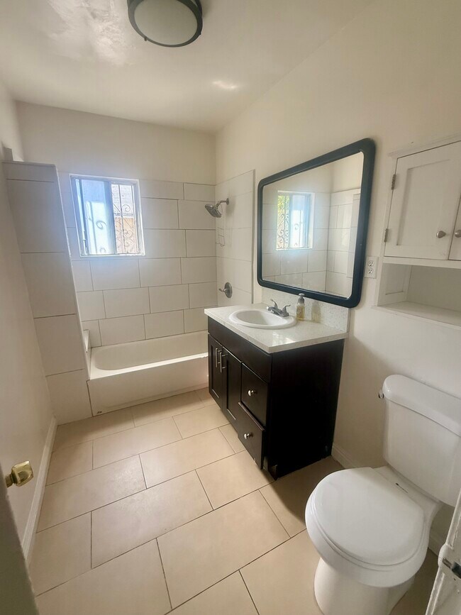
Bathroom
-
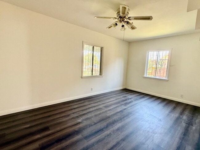
Bedroom 1
-
Bedroom 2
-
Kitchen
-
Dining Room
What Are Walk Score®, Transit Score®, and Bike Score® Ratings?
Walk Score® measures the walkability of any address. Transit Score® measures access to public transit. Bike Score® measures the bikeability of any address.
What is a Sound Score Rating?
A Sound Score Rating aggregates noise caused by vehicle traffic, airplane traffic and local sources.
330 W Bencamp St
San Gabriel, CA 91776