

$4,200 / Month
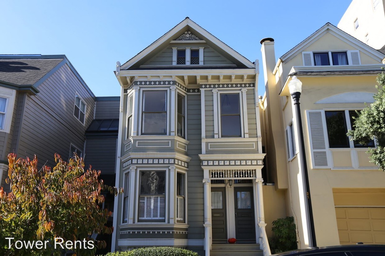
325 Walnut St
San Francisco, CA 94118
2 Weeks Ago
Favorites
325 Walnut St

Favorites
Check Back Soon for Upcoming Availability
| Beds | Baths | Average SF |
|---|---|---|
| 2 Bedrooms 2 Bedrooms 2 Br | 1 Bath 1 Bath 1 Ba | — |
About This Property
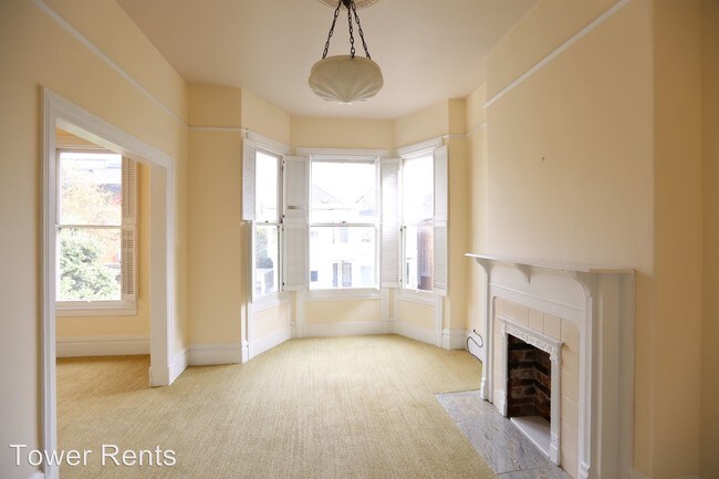
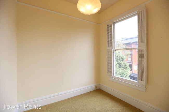
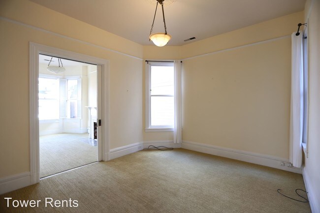
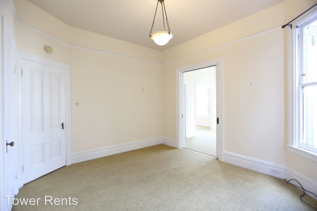
(415) 797-8296 - Presidio Heights: Top Floor 2 Bed 1 Bath Flat w/ Deck & W/D - This top floor apartment in a lovely 2 unit building is bright, sunny and spacious. It features both carpet and hardwood floors, high ceilings and nice period details. Adjacent to the shops and restaurants on Sacramento Street, and just one more block to California street, this home is located in the heart of one of the most beautiful and distinctive districts for shopping and dining. Just around the corner from a playground, and 3 blocks away from all the recreation available in the Presidio. The roomy kitchen has upgraded appliances including a gas range, lots of cabinet and counter space, plus a large pantry. Extra amenities include an in-unit washer and dryer, sun room, and a sunny, south-facing private deck. Street parking only, which is relatively easy in this area. 12 month lease (unfurnished). Square footage is approximate. Non-smoking unit. (RLNE2758806)
325 Walnut St is a condo located in San Francisco County and the 94118 ZIP Code. This area is served by the San Francisco Unified attendance zone.
Location
Get Directions
An affluent neighborhood in northern San Francisco, Presidio Heights offers family-friendly living with luxury apartments and classic urban townhomes for rent. This upscale neighborhood borders Presidio, a 1,500-acre park that’s a major outdoor recreation hub for the city of San Francisco. Discover forests, miles of trails, a golf course, and gorgeous scenic overlooks of the San Francisco Bay.
At the park, visit the grassy Crissy Field with views of the Golden Gate Bridge, enjoy the sandy banks of Baker Beach, admire historic homes, explore the Walt Disney Family Museum, see a show at the Palace of Fine Arts Theatre, and visit the historic Fort Point.
Public and private schools are available in the area, and the neighborhood is located just north of the University of California San Francisco Laurel Heights campus. Residents have access to public transit through local bus stations and enjoy both walkable and bike-friendly streets.
Learn more about living in Presidio HeightsBelow are rent ranges for similar nearby apartments
Education
| Colleges & Universities | Distance | ||
|---|---|---|---|
| Colleges & Universities | Distance | ||
| Walk: | 16 min | 0.8 mi | |
| Walk: | 19 min | 1.0 mi | |
| Drive: | 7 min | 2.5 mi | |
| Drive: | 8 min | 3.0 mi |
325 Walnut St is within 16 minutes or 0.8 mile from UC San Francisco, Mount Zion. It is also near University of San Francisco and Academy of Art University.
Schools


Public Elementary School
Grades K-5
Nearby
Public Elementary School
Grades K-5
219 Students
Attendance Zone
Public Middle School
Grades 6-8
666 Students
Attendance Zone
Public High School
Grades 9-12
549 Students
Attendance Zone
Private Elementary & Middle School
Grades K-8
223 Students
Nearby
Private Elementary & Middle School
Grades 3-8
8 Students
Nearby
Private High School
Grades 9-12
416 Students
Nearby
School data provided by
 The GreatSchools Rating helps parents compare schools within a state based on a variety of school quality indicators and provides a helpful picture of how effectively each school serves all of its students. Ratings are on a scale of 1 (below average) to 10 (above average) and can include test scores, college readiness, academic progress, advanced courses, equity, discipline and attendance data. We also advise parents to visit schools, consider other information on school performance and programs, and consider family needs as part of the school selection process.
View GreatSchools Rating Methodology
Data provided by GreatSchools.org © 2025. All rights reserved.
View GreatSchools Rating Methodology
Data provided by GreatSchools.org © 2025. All rights reserved.
Transportation options available in San Francisco include California And Van Ness, located 1.6 miles from 325 Walnut St. 325 Walnut St is near San Francisco International, located 15.7 miles or 26 minutes away, and Metro Oakland International, located 21.7 miles or 36 minutes away.
| Transit / Subway | Distance | ||
|---|---|---|---|
| Transit / Subway | Distance | ||
|
|
Drive: | 4 min | 1.6 mi |
| Drive: | 5 min | 1.7 mi | |
|
|
Drive: | 5 min | 1.9 mi |
| Drive: | 5 min | 1.9 mi | |
|
|
Drive: | 6 min | 2.1 mi |
| Commuter Rail | Distance | ||
|---|---|---|---|
| Commuter Rail | Distance | ||
| Drive: | 10 min | 4.8 mi | |
| Drive: | 10 min | 4.9 mi | |
| Drive: | 12 min | 5.6 mi | |
| Drive: | 12 min | 5.7 mi | |
| Drive: | 15 min | 7.9 mi |
| Airports | Distance | ||
|---|---|---|---|
| Airports | Distance | ||
|
San Francisco International
|
Drive: | 26 min | 15.7 mi |
|
Metro Oakland International
|
Drive: | 36 min | 21.7 mi |
Time and distance from 325 Walnut St.
| Shopping Centers | Distance | ||
|---|---|---|---|
| Shopping Centers | Distance | ||
| Walk: | 15 min | 0.8 mi | |
| Drive: | 3 min | 1.3 mi | |
| Drive: | 5 min | 1.9 mi |
325 Walnut St has 3 shopping centers within 1.9 miles, which is about a 5-minute walk. The miles and minutes will be for the farthest away property.
| Parks and Recreation | Distance | ||
|---|---|---|---|
| Parks and Recreation | Distance | ||
|
Conservatory of Flowers
|
Drive: | 4 min | 1.5 mi |
|
Exploratorium
|
Drive: | 4 min | 1.5 mi |
|
Buena Vista Park
|
Drive: | 6 min | 2.0 mi |
|
California Academy of Sciences
|
Drive: | 7 min | 2.3 mi |
|
Presidio of San Francisco
|
Drive: | 8 min | 2.9 mi |
325 Walnut St has 5 parks within 2.9 miles, including Exploratorium, Conservatory of Flowers, and Buena Vista Park.
| Hospitals | Distance | ||
|---|---|---|---|
| Hospitals | Distance | ||
| Walk: | 12 min | 0.7 mi | |
| Drive: | 3 min | 1.4 mi | |
| Drive: | 5 min | 2.0 mi |
325 Walnut St has 3 hospitals within 2.0 miles, the nearest is Kaiser Foundation Hospital - San Francisco which is 0.7 mile away and a 12 minute walk.
| Military Bases | Distance | ||
|---|---|---|---|
| Military Bases | Distance | ||
| Drive: | 10 min | 3.2 mi | |
| Drive: | 11 min | 3.6 mi | |
| Drive: | 18 min | 7.8 mi |
325 Walnut St has 3 military bases within 7.8 miles, the nearest is East Fort Miley which is 3.2 miles away and a 10 minute drive.
You May Also Like
Similar Rentals Nearby
-
-

-

-

-
1 / 36

-

-
-
-
-


What Are Walk Score®, Transit Score®, and Bike Score® Ratings?
Walk Score® measures the walkability of any address. Transit Score® measures access to public transit. Bike Score® measures the bikeability of any address.
What is a Sound Score Rating?
A Sound Score Rating aggregates noise caused by vehicle traffic, airplane traffic and local sources
325 Walnut St
San Francisco, CA 94118