$2,800
/ Month
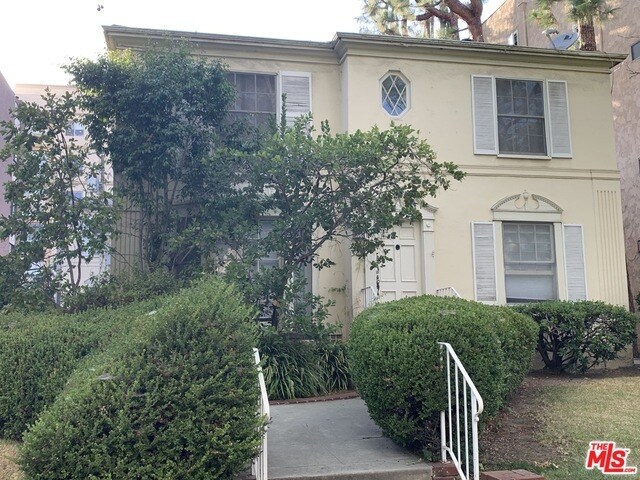
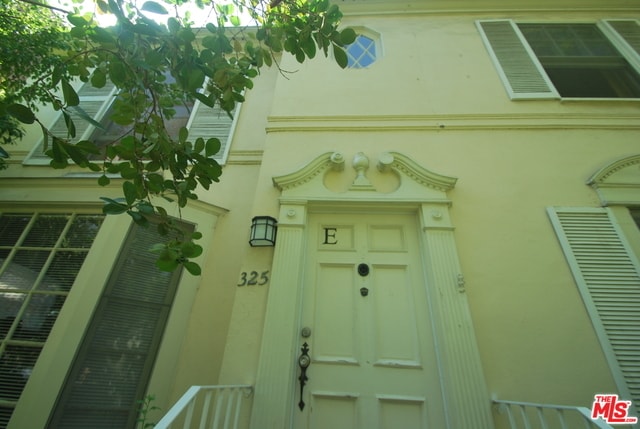
325 N Palm Dr
Beverly Hills, CA 90210
2 Weeks Ago
|
Edit
Favorites
325 N Palm Dr

Favorites
Check Back Soon for Upcoming Availability
| Beds | Baths | Average SF |
|---|---|---|
| 1 Bedroom 1 Bedroom 1 Br | 1 Bath 1 Bath 1 Ba | 900 SF |
About This Property
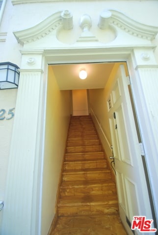
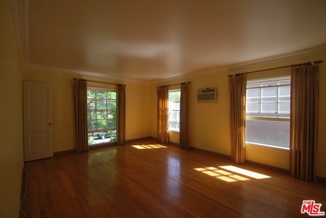
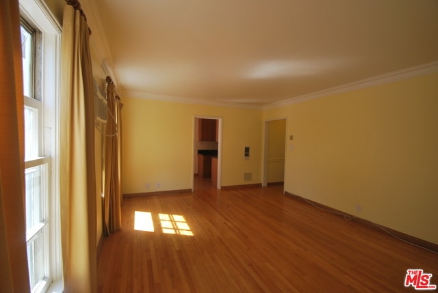
Available either furnished or unfurnished, this fabulous top floor Beverly Hills apartment unit is in the front of the building and features beautiful treetop views of Jacaranda trees and lots of sunlight. The home is walking distance to markets, fabulous restaurants, and West Hollywood's Design District. Also nearby are Cedars Sinai Medical Center and shopping malls. This second level apartment unit features its own separate entry, hardwood floors, and a renovated kitchen.. The price with furnishings is $3,800.
325 N Palm Dr is a townhome located in Los Angeles County and the 90210 ZIP Code. This area is served by the Beverly Hills Unified attendance zone.
Townhome Features
- Washer/Dryer Hookup
- Hardwood Floors
- Views
- Laundry Facilities
Location
Get Directions
Beverly Hills, spanning just 5.71 square miles, combines elegant residential areas with world-class shopping and dining. Tree-lined streets and well-maintained green spaces like Beverly Gardens Park along Santa Monica Boulevard create an inviting atmosphere. The Golden Triangle shopping district, home to the renowned Rodeo Drive, offers high-end retail experiences. Housing options range from estates in Trousdale Estates to apartments south of Wilshire Boulevard, where one-bedroom apartments currently average $2,728 with a 1.1% increase year-over-year.
The city celebrates arts and culture through venues like the Wallis Annenberg Center for the Performing Arts and the historic Greystone Mansion. Landmarks such as the Beverly Hills Hotel and Beverly Wilshire Hotel contribute to the area's distinctive character. Notable areas include the residential streets north of Santa Monica Boulevard and the South Beverly Drive district, with its local shops and eateries.
Learn more about living in Beverly Hills
Amenities
- Washer/Dryer Hookup
- Hardwood Floors
- Views
- Laundry Facilities
Education
| Colleges & Universities | Distance | ||
|---|---|---|---|
| Colleges & Universities | Distance | ||
| Drive: | 10 min | 4.2 mi | |
| Drive: | 10 min | 4.7 mi | |
| Drive: | 10 min | 5.1 mi | |
| Drive: | 16 min | 6.1 mi |
325 N Palm Dr is within 10 minutes or 4.2 miles from UCLA. It is also near Musicians Institute and Los Angeles Film School.
Schools


Public Elementary School
Grades K-5
393 Students
Nearby
Public Elementary School
Grades K-5
569 Students
Attendance Zone
Public High School
Grades 9-12
1,220 Students
Attendance Zone
Private Elementary & Middle School
Grades PK-8
531 Students
Nearby
Private Elementary School
Grades PK-6
Nearby
Private Middle & High School
Grades 6-12
Nearby
School data provided by
 The GreatSchools Rating helps parents compare schools within a state based on a variety of school quality indicators and provides a helpful picture of how effectively each school serves all of its students. Ratings are on a scale of 1 (below average) to 10 (above average) and can include test scores, college readiness, academic progress, advanced courses, equity, discipline and attendance data. We also advise parents to visit schools, consider other information on school performance and programs, and consider family needs as part of the school selection process.
View GreatSchools Rating Methodology
Data provided by GreatSchools.org © 2025. All rights reserved.
View GreatSchools Rating Methodology
Data provided by GreatSchools.org © 2025. All rights reserved.
Transportation options available in Beverly Hills include Palms, located 3.8 miles from 325 N Palm Dr. 325 N Palm Dr is near Los Angeles International, located 11.7 miles or 23 minutes away, and Bob Hope, located 13.0 miles or 25 minutes away.
| Transit / Subway | Distance | ||
|---|---|---|---|
| Transit / Subway | Distance | ||
|
|
Drive: | 10 min | 3.8 mi |
|
|
Drive: | 9 min | 3.9 mi |
|
|
Drive: | 10 min | 4.4 mi |
| Drive: | 10 min | 4.5 mi | |
|
|
Drive: | 9 min | 4.6 mi |
| Commuter Rail | Distance | ||
|---|---|---|---|
| Commuter Rail | Distance | ||
|
|
Drive: | 19 min | 9.8 mi |
|
|
Drive: | 21 min | 9.9 mi |
|
|
Drive: | 20 min | 10.6 mi |
|
|
Drive: | 22 min | 11.0 mi |
|
|
Drive: | 24 min | 11.9 mi |
| Airports | Distance | ||
|---|---|---|---|
| Airports | Distance | ||
|
Los Angeles International
|
Drive: | 23 min | 11.7 mi |
|
Bob Hope
|
Drive: | 25 min | 13.0 mi |
Time and distance from 325 N Palm Dr.
| Shopping Centers | Distance | ||
|---|---|---|---|
| Shopping Centers | Distance | ||
| Walk: | 15 min | 0.8 mi | |
| Walk: | 15 min | 0.8 mi | |
| Walk: | 16 min | 0.9 mi |
325 N Palm Dr has 3 shopping centers within 0.9 mile, which is about a 16-minute walk. The miles and minutes will be for the farthest away property.
| Parks and Recreation | Distance | ||
|---|---|---|---|
| Parks and Recreation | Distance | ||
|
Zimmer Children's Museum
|
Drive: | 4 min | 1.9 mi |
|
Virginia Robinson Gardens
|
Drive: | 6 min | 2.0 mi |
|
La Brea Tar Pits
|
Drive: | 5 min | 2.6 mi |
|
Mathias Botanical Garden
|
Drive: | 9 min | 3.7 mi |
|
Hannah Carter Japanese Garden
|
Drive: | 10 min | 4.3 mi |
325 N Palm Dr has 5 parks within 4.3 miles, including Zimmer Children's Museum, Virginia Robinson Gardens, and La Brea Tar Pits.
| Hospitals | Distance | ||
|---|---|---|---|
| Hospitals | Distance | ||
| Walk: | 16 min | 0.8 mi | |
| Drive: | 4 min | 2.4 mi | |
| Drive: | 5 min | 2.5 mi |
325 N Palm Dr has 3 hospitals within 2.5 miles, the nearest is Cedars-Sinai Medical Center which is 0.8 mile away and a 16 minute walk.
| Military Bases | Distance | ||
|---|---|---|---|
| Military Bases | Distance | ||
| Drive: | 23 min | 13.3 mi |
325 N Palm Dr is 13.3 miles and a 23 minute drive from Los Angeles Air Force Base.
You May Also Like
Similar Rentals Nearby
-
-
-
-
-
-
-
1 / 35

-
-
-


What Are Walk Score®, Transit Score®, and Bike Score® Ratings?
Walk Score® measures the walkability of any address. Transit Score® measures access to public transit. Bike Score® measures the bikeability of any address.
What is a Sound Score Rating?
A Sound Score Rating aggregates noise caused by vehicle traffic, airplane traffic and local sources

325 N Palm Dr
Beverly Hills, CA 90210