
$3,500 / Month
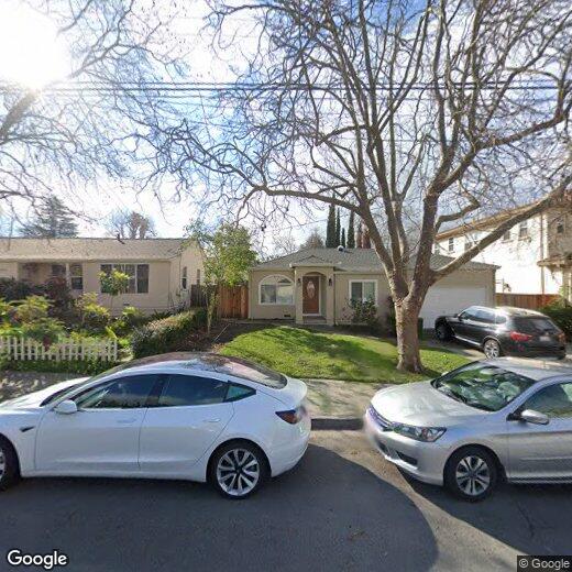
318 Escobar St
Fremont, CA 94539
2 Weeks Ago
Favorites
318 Escobar St

Favorites
Check Back Soon for Upcoming Availability
| Beds | Baths | Average SF |
|---|---|---|
| 3 Bedrooms 3 Bedrooms 3 Br | 2 Baths 2 Baths 2 Ba | 1,281 SF |
About This Property
Beautiful single family home for a tasteful living in top rated Mission school district. 3 Bedrooms and 2 Full bathrooms, very close to Ohlone college, bus stop and Warm Springs Bart station for easy commute to San Francisco. Close to I-680(1 min drive) and I-880 Hwy. Walk-able to top rated Mission San Jose Elementary school (0.3 mile), William Hopkins Junior High School(1.4 mile) and Mission San Jose High School (1 mile). Sun tunnel in Kitchen. Bright sun light everywhere, beautiful backyard and frontyard with fresh landscaping, artificial turf and wooden deck. Remodeled/Cherry Cabinet, Tile Floor in Kitchen and Baths, Granite Countertop, Newer Stove, Newer Dishwasher, Newer washer and dryer, Fridge/Dual Pane Windows/Jacuzzi/Double Sink in Baths/Newer Paint/Newer Water Heater/Newer Garage Door. No Smoking. 1 year Lease. Rent - $3,500 Deposit - $3,500 Available 17th August, 2019.
318 Escobar St is a house located in Alameda County and the 94539 ZIP Code. This area is served by the Fremont Unified attendance zone.
Location
Get Directions
Fremont is a charming city in the San Francisco Bay Area that sits across the Bay from the Silicon Valley. It is known as an ideal destination for families, offering kid-friendly attractions and excellent public schools like the Children’s Natural History Museum and Washington High School. The rapid expansion of the tech industry in recent years has boosted Fremont’s reputation as a commuter-friendly city for those working in the Silicon Valley. Fremont is located directly north of San Jose, and Palo Alto is a short drive across the Dumbarton Bridge on the Bay.
Fremont’s local culture incorporates the area’s rich history and thriving arts scene. Check out the Old Town Niles region that features a popular art walk, antique fair, and a museum celebrating the town’s role in the early days of motion picture production. Exquisite historic architecture is on display around the city, so be sure to explore Fremont’s picturesque streets that blend urban amenities and suburban neighborhoods.
Learn more about living in FremontBelow are rent ranges for similar nearby apartments
Education
| Colleges & Universities | Distance | ||
|---|---|---|---|
| Colleges & Universities | Distance | ||
| Walk: | 16 min | 0.9 mi | |
| Drive: | 12 min | 5.9 mi | |
| Drive: | 18 min | 11.1 mi | |
| Drive: | 25 min | 12.9 mi |
318 Escobar St is within 16 minutes or 0.9 mile from Ohlone College, Fremont Campus. It is also near Ohlone College, Newark and Palmer College of Chiropractic West Campus.
Schools


Public Elementary School
Grades K-5
343 Students
Nearby
Public Elementary School
Grades 1-5
456 Students
Attendance Zone
Public Middle School
Grades 6-8
909 Students
Attendance Zone
Public High School
Grades 9-12
1,878 Students
Attendance Zone
Private Elementary & Middle School
Grades K-8
217 Students
Nearby
Private Elementary School
Grades PK-6
231 Students
Nearby
Private Middle & High School
Grades 7-12
Nearby
School data provided by
 The GreatSchools Rating helps parents compare schools within a state based on a variety of school quality indicators and provides a helpful picture of how effectively each school serves all of its students. Ratings are on a scale of 1 (below average) to 10 (above average) and can include test scores, college readiness, academic progress, advanced courses, equity, discipline and attendance data. We also advise parents to visit schools, consider other information on school performance and programs, and consider family needs as part of the school selection process.
View GreatSchools Rating Methodology
Data provided by GreatSchools.org © 2025. All rights reserved.
View GreatSchools Rating Methodology
Data provided by GreatSchools.org © 2025. All rights reserved.
Transportation options available in Fremont include Warm Springs / South Fremont, located 3.9 miles from 318 Escobar St. 318 Escobar St is near Norman Y Mineta San Jose International, located 15.2 miles or 22 minutes away, and Metro Oakland International, located 25.5 miles or 36 minutes away.
| Transit / Subway | Distance | ||
|---|---|---|---|
| Transit / Subway | Distance | ||
|
|
Drive: | 8 min | 3.9 mi |
|
|
Drive: | 10 min | 4.3 mi |
|
|
Drive: | 10 min | 4.5 mi |
|
|
Drive: | 16 min | 8.1 mi |
|
|
Drive: | 15 min | 9.8 mi |
| Commuter Rail | Distance | ||
|---|---|---|---|
| Commuter Rail | Distance | ||
| Drive: | 11 min | 5.4 mi | |
| Drive: | 12 min | 5.4 mi | |
| Drive: | 16 min | 11.8 mi | |
| Drive: | 16 min | 11.8 mi | |
| Drive: | 19 min | 12.8 mi |
| Airports | Distance | ||
|---|---|---|---|
| Airports | Distance | ||
|
Norman Y Mineta San Jose International
|
Drive: | 22 min | 15.2 mi |
|
Metro Oakland International
|
Drive: | 36 min | 25.5 mi |
Time and distance from 318 Escobar St.
| Shopping Centers | Distance | ||
|---|---|---|---|
| Shopping Centers | Distance | ||
| Walk: | 5 min | 0.3 mi | |
| Walk: | 16 min | 0.9 mi | |
| Drive: | 4 min | 2.1 mi |
318 Escobar St has 3 shopping centers within 2.1 miles, which is about a 4-minute walk. The miles and minutes will be for the farthest away property.
| Parks and Recreation | Distance | ||
|---|---|---|---|
| Parks and Recreation | Distance | ||
|
Central Park (Lake Elizabeth)
|
Drive: | 9 min | 4.1 mi |
|
Mission Peak Regional Preserve
|
Drive: | 17 min | 4.6 mi |
|
Niles Canyon Railway
|
Drive: | 10 min | 5.1 mi |
|
Niles Community Park
|
Drive: | 12 min | 5.7 mi |
|
Sunol Regional Wilderness
|
Drive: | 25 min | 11.5 mi |
318 Escobar St has 5 parks within 11.5 miles, including Central Park (Lake Elizabeth), Mission Peak Regional Preserve, and Niles Canyon Railway.
| Hospitals | Distance | ||
|---|---|---|---|
| Hospitals | Distance | ||
| Drive: | 8 min | 3.6 mi | |
| Drive: | 10 min | 4.5 mi |
318 Escobar St is 3.6 miles from Kaiser Foundation Hospital - Fremont, and is convenient to other hospitals, including Washington Hospital.
| Military Bases | Distance | ||
|---|---|---|---|
| Military Bases | Distance | ||
| Drive: | 27 min | 17.9 mi |
318 Escobar St is 17.9 miles and a 27 minute drive from Ames Research Center.
You May Also Like
Similar Rentals Nearby


What Are Walk Score®, Transit Score®, and Bike Score® Ratings?
Walk Score® measures the walkability of any address. Transit Score® measures access to public transit. Bike Score® measures the bikeability of any address.
What is a Sound Score Rating?
A Sound Score Rating aggregates noise caused by vehicle traffic, airplane traffic and local sources

318 Escobar St
Fremont, CA 94539