1 / 9


Bedrooms
4
Bathrooms
1.5
Square Feet
1,840 sq ft

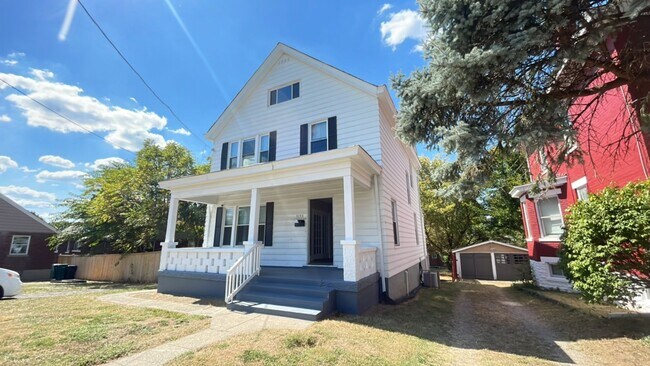
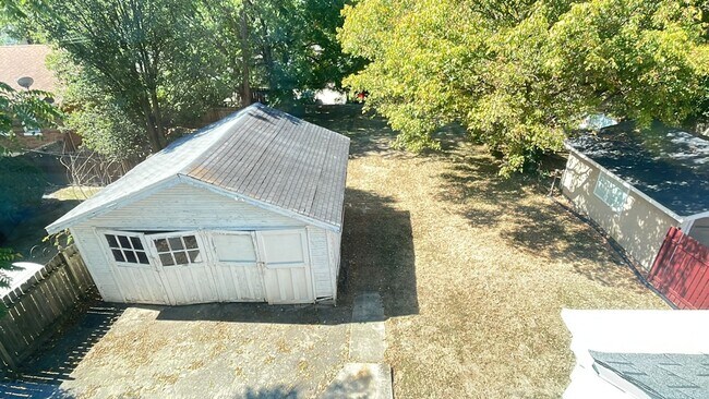
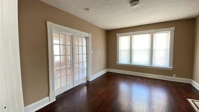
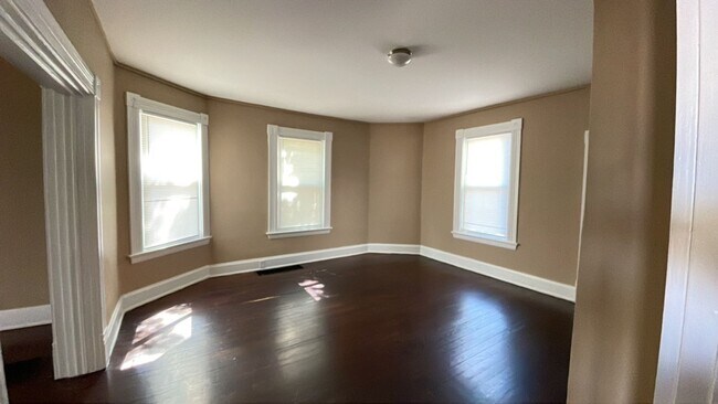
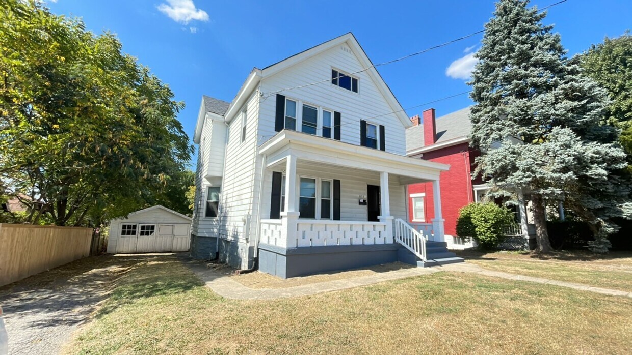
Welcome to 3153 Glenmore Ave, a beautifully updated 4 bedroom, 1.5 bathroom home in Cincinnati, OH. Managed by Dix Road Property Management LLC, this property boasts updated electrical and plumbing, a modern kitchen with dishwasher and disposal, separate dining area, and updated bathrooms. Enjoy the convenience of a W/D hookup, utility tub, central air, and a mix of laminate and hardwood flooring throughout. The full basement provides extra storage space, while the 2 car detached garage and patio offer outdoor living options. This pet-friendly home, located in the Cincinnati CSD, also features off-street parking for added convenience. Don't miss out on this fantastic opportunity to make 3153 Glenmore Ave your new home! **Appliances are not included, but can be for an additional cost.** **DEPOSIT PENDING**
3153 Glenmore Ave is a house located in Hamilton County and the 45211 ZIP Code. This area is served by the Cincinnati Public Schools attendance zone.
Situated about five miles northwest of Downtown Cincinnati, Westwood is the largest neighborhood in the city. Residents flock to Westwood for its many affordable historic homes and modern apartments available for rent in addition to its close proximity to I-74, I-75, and all that Downtown Cincinnati has to offer.
While Westwood is a predominantly residential neighborhood, it is also home to a slew of convenient stores and restaurants. Shopping opportunities abound in Westwood, with plenty of national retailers in Western Hills Plaza and local shops in the growing Town Hall District. Numerous neighborhood parks provide ample space to enjoy the outdoors in town as well as the sprawling 1,400-acre Mount Airy Forest, which is partially located in Westwood.
Learn more about living in Westwood| Colleges & Universities | Distance | ||
|---|---|---|---|
| Colleges & Universities | Distance | ||
| Drive: | 10 min | 4.5 mi | |
| Drive: | 15 min | 6.3 mi | |
| Drive: | 14 min | 6.6 mi | |
| Drive: | 15 min | 7.0 mi |


Transportation options available in Cincinnati include Brewery District Station - Elm & Henry, located 5.8 miles from 3153 Glenmore Ave. 3153 Glenmore Ave is near Cincinnati/Northern Kentucky International, located 20.2 miles or 39 minutes away.
| Transit / Subway | Distance | ||
|---|---|---|---|
| Transit / Subway | Distance | ||
| Drive: | 14 min | 5.8 mi | |
| Drive: | 14 min | 6.1 mi | |
| Drive: | 15 min | 6.1 mi | |
| Drive: | 15 min | 6.2 mi | |
| Drive: | 15 min | 6.4 mi |
| Commuter Rail | Distance | ||
|---|---|---|---|
| Commuter Rail | Distance | ||
|
|
Drive: | 14 min | 6.1 mi |
| Airports | Distance | ||
|---|---|---|---|
| Airports | Distance | ||
|
Cincinnati/Northern Kentucky International
|
Drive: | 39 min | 20.2 mi |
Scores provided by
Traffic
-Airport
-Businesses
-Scores provided by
HowLoud What is a Sound Score Rating? A Sound Score Rating aggregates noise caused by vehicle traffic, airplane traffic and local sources. How It WorksTime and distance from 3153 Glenmore Ave.
| Shopping Centers | Distance | ||
|---|---|---|---|
| Shopping Centers | Distance | ||
| Walk: | 11 min | 0.6 mi | |
| Walk: | 14 min | 0.7 mi | |
| Walk: | 15 min | 0.8 mi |
| Parks and Recreation | Distance | ||
|---|---|---|---|
| Parks and Recreation | Distance | ||
|
Mt. Airy Forest
|
Drive: | 9 min | 3.7 mi |
|
Imago Earth Center
|
Drive: | 11 min | 4.1 mi |
|
Embshoff Woods
|
Drive: | 14 min | 4.7 mi |
|
Wilson Commons
|
Drive: | 13 min | 4.8 mi |
|
Buttercup Valley
|
Drive: | 12 min | 5.3 mi |
| Hospitals | Distance | ||
|---|---|---|---|
| Hospitals | Distance | ||
| Drive: | 9 min | 3.8 mi | |
| Drive: | 12 min | 5.9 mi | |
| Drive: | 15 min | 7.1 mi |
| Military Bases | Distance | ||
|---|---|---|---|
| Military Bases | Distance | ||
| Drive: | 75 min | 56.1 mi | |
| Drive: | 81 min | 61.1 mi | |
| Drive: | 83 min | 64.4 mi |


What Are Walk Score®, Transit Score®, and Bike Score® Ratings?
Walk Score® measures the walkability of any address. Transit Score® measures access to public transit. Bike Score® measures the bikeability of any address.
What is a Sound Score Rating?
A Sound Score Rating aggregates noise caused by vehicle traffic, airplane traffic and local sources.
3153 Glenmore Ave
Cincinnati, OH 45211