

$3,750
/ Month
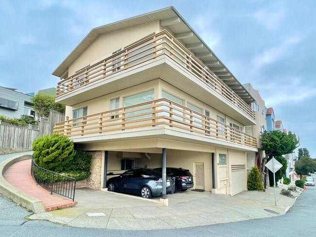
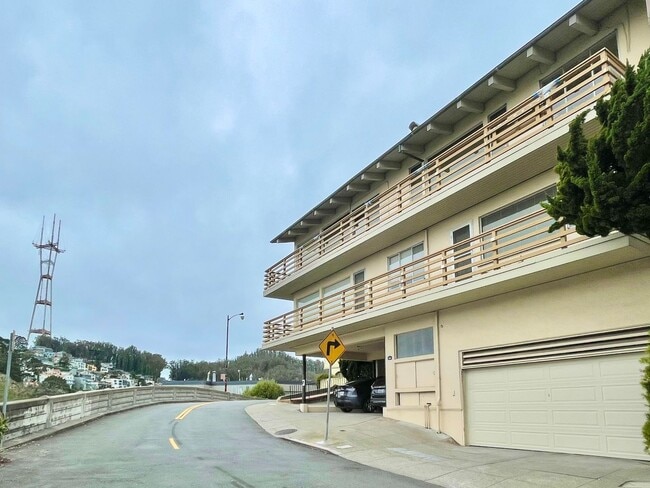
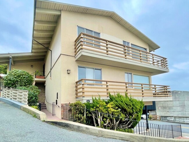
312 Upper Terrace
San Francisco, CA 94117
2 Weeks Ago
Favorites
-
Bedrooms
1
-
Bathrooms
1
-
Square Feet
--
312 Upper Terrace

Favorites
About This Home
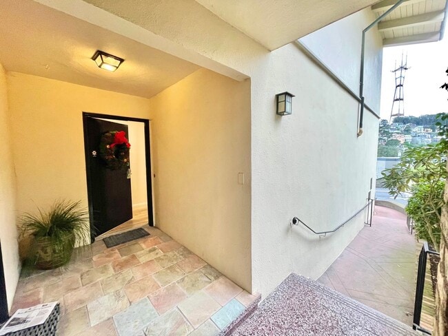
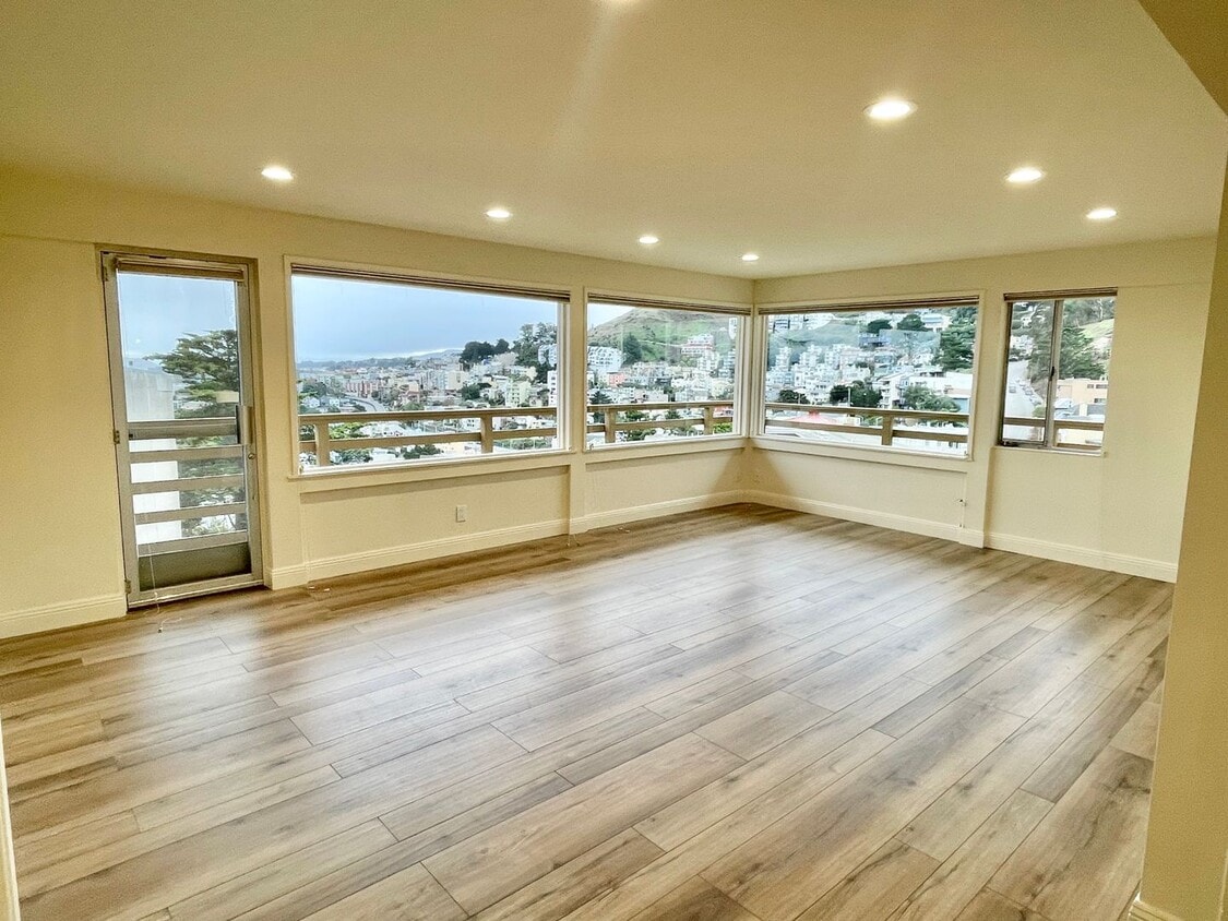
Location, location, location! Centrally situated at the pinnacle of Ashbury Heights. Equal distance to the vibrant neighborhoods of Cole Valley, Castro, and the Haight! Restaurant, bar, fitness and shopping options abound! Plus the most stunning views in the City! Enter this lovingly updated, elegant flat through a private entrance. The handsome living room boasts large windows which flood the unit with sunlight and offer jaw-dropping views! Enjoy sunsets and sunrises from the large private balcony! The newly renovated eat-in kitchen features high-end stainless steel stove, refrigerator, dishwasher and oodles of custom cabinet space. Enjoy the pano views as you share meals with family and friends! The newly renovated spa-like bathroom features striking custom tilework, a deep soaking tub, and a separate walk-in shower! The large bedroom also features views and ample closet space. Room for a king size bed! Additional features include: - Views, views, views!!! - New wooden flooring throughout - Shared washer/dryer (free!) - Designated storage area - One car optional parking ($250 per month) - Intimate 4 unit building Terms: - Rent: $3,750/month - Security Deposit: 1.5x one month’s rent - Tenant pays PGE, cable/phone/internet, water and garbage (both back billed by owner) - Ready for immediate occupancy - No pets; we do follow all applicable rental laws - Optional one car carport parking $250 per month - No smoking For showings, please TEXT or reply to this ad LOCATION: 312 Upper Terrace @ Clifford Terrace CA DRE License #01905856 Progressive Property Group, Inc.
312 Upper Terrace is a house located in San Francisco County and the 94117 ZIP Code. This area is served by the San Francisco Unified attendance zone.
* Price shown is base rent. Excludes user-selected optional fees and variable or usage-based fees and required charges due at or prior to move-in or at move-out. Price, availability, fees, and any applicable rent special are subject to change without notice.
* Square footage definitions vary. Displayed square footage is approximate.
Contact
- Listed by Progressive Property Group, Inc. | Progressive Property Group, Inc.
Location
Get Directions
Cole Valley nestles up against the southwest corner of Golden Gate Park in San Francisco. This tiny neighborhood contains mostly residential Victorian homes, with a small, densely packed three-block commercial district along Cole Street. Commuters use the mass transit station in the center of the district to reach downtown San Francisco in less than 20 minutes, and then they return home to Cole Valley's small-town atmosphere.
This neighborhood's small size means every corner of the community is within walking distance from your rental home. After work, relax and take in spectacular views of San Francisco from Tank Hill Park, which rises 600 feet above the city at the end of Belgrave Avenue. On weekends, enjoy Florentine Eggs Benedict for brunch at Zazie or have coffee with friends on Cafe Reverie's patio.
Learn more about living in Cole Valley
Education
| Colleges & Universities | Distance | ||
|---|---|---|---|
| Colleges & Universities | Distance | ||
| Drive: | 5 min | 1.9 mi | |
| Drive: | 6 min | 1.9 mi | |
| Drive: | 7 min | 2.2 mi | |
| Drive: | 9 min | 3.0 mi |
312 Upper Terrace is within 5 minutes or 1.9 miles from University of San Francisco. It is also near UC San Francisco, Parnassus and UC San Francisco, Mount Zion.
Schools


Public Elementary School
Grades K-5
Nearby
Public Elementary School
Grades K-5
253 Students
Attendance Zone
Public Middle School
Grades 6-8
504 Students
Attendance Zone
Public High School
Grades 9-12
320 Students
Attendance Zone
Public High School
Grades 9-12
1,041 Students
Attendance Zone
Private Elementary, Middle & High School
Grades 2-12
8 Students
Nearby
Private Middle School
Grades 6-8
Nearby
Private High School
Grades 9-12
421 Students
Nearby
School data provided by
 The GreatSchools Rating helps parents compare schools within a state based on a variety of school quality indicators and provides a helpful picture of how effectively each school serves all of its students. Ratings are on a scale of 1 (below average) to 10 (above average) and can include test scores, college readiness, academic progress, advanced courses, equity, discipline and attendance data. We also advise parents to visit schools, consider other information on school performance and programs, and consider family needs as part of the school selection process.
View GreatSchools Rating Methodology
Data provided by GreatSchools.org © 2025. All rights reserved.
View GreatSchools Rating Methodology
Data provided by GreatSchools.org © 2025. All rights reserved.
Transportation options available in San Francisco include Carl And Cole, located 0.5 mile from 312 Upper Terrace. 312 Upper Terrace is near San Francisco International, located 14.9 miles or 25 minutes away, and Metro Oakland International, located 22.3 miles or 36 minutes away.
| Transit / Subway | Distance | ||
|---|---|---|---|
| Transit / Subway | Distance | ||
|
|
Walk: | 9 min | 0.5 mi |
| Walk: | 10 min | 0.5 mi | |
|
|
Walk: | 13 min | 0.7 mi |
|
|
Walk: | 14 min | 0.7 mi |
|
|
Drive: | 4 min | 1.3 mi |
| Commuter Rail | Distance | ||
|---|---|---|---|
| Commuter Rail | Distance | ||
| Drive: | 8 min | 3.4 mi | |
| Drive: | 9 min | 3.5 mi | |
| Drive: | 10 min | 4.3 mi | |
| Drive: | 10 min | 4.3 mi | |
| Drive: | 14 min | 7.0 mi |
| Airports | Distance | ||
|---|---|---|---|
| Airports | Distance | ||
|
San Francisco International
|
Drive: | 25 min | 14.9 mi |
|
Metro Oakland International
|
Drive: | 36 min | 22.3 mi |
Time and distance from 312 Upper Terrace.
| Shopping Centers | Distance | ||
|---|---|---|---|
| Shopping Centers | Distance | ||
| Walk: | 18 min | 1.0 mi | |
| Drive: | 6 min | 1.6 mi | |
| Drive: | 6 min | 2.2 mi |
312 Upper Terrace has 3 shopping centers within 2.2 miles, which is about a 6-minute walk. The miles and minutes will be for the farthest away property.
| Parks and Recreation | Distance | ||
|---|---|---|---|
| Parks and Recreation | Distance | ||
|
Buena Vista Park
|
Walk: | 10 min | 0.6 mi |
|
Randall Museum
|
Walk: | 12 min | 0.6 mi |
|
Conservatory of Flowers
|
Drive: | 4 min | 1.7 mi |
|
California Academy of Sciences
|
Drive: | 7 min | 2.4 mi |
|
Steinhart Aquarium
|
Drive: | 7 min | 2.5 mi |
312 Upper Terrace has 5 parks within 2.5 miles, including Buena Vista Park, Randall Museum, and Conservatory of Flowers.
| Hospitals | Distance | ||
|---|---|---|---|
| Hospitals | Distance | ||
| Walk: | 17 min | 0.9 mi | |
| Drive: | 3 min | 1.3 mi | |
| Drive: | 3 min | 1.3 mi |
312 Upper Terrace has 3 hospitals within 1.3 miles, the nearest is California Pacific Medical Center - Davies Campus which is 0.9 mile away and a 17 minute walk.
| Military Bases | Distance | ||
|---|---|---|---|
| Military Bases | Distance | ||
| Drive: | 13 min | 4.6 mi | |
| Drive: | 13 min | 5.1 mi |
312 Upper Terrace is 4.6 miles from East Fort Miley, and is convenient to other military bases, including West Fort Miley.
You May Also Like
Similar Rentals Nearby


What Are Walk Score®, Transit Score®, and Bike Score® Ratings?
Walk Score® measures the walkability of any address. Transit Score® measures access to public transit. Bike Score® measures the bikeability of any address.
What is a Sound Score Rating?
A Sound Score Rating aggregates noise caused by vehicle traffic, airplane traffic and local sources
312 Upper Terrace
San Francisco, CA 94117