

$875
/ Month
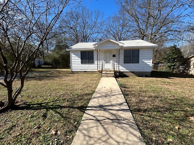
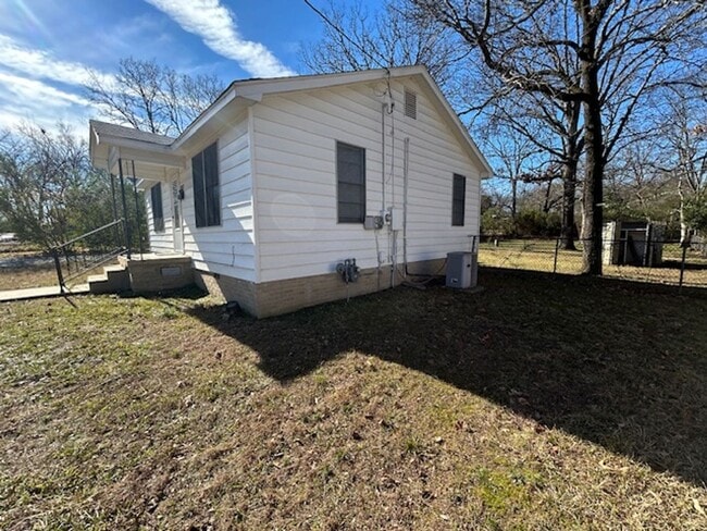
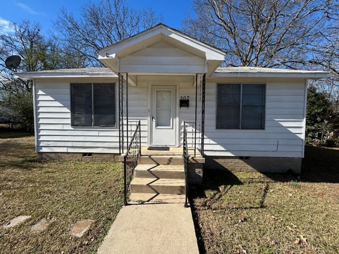
307 S Fairway Ave
Sherwood, AR 72120
Today
|
Edit
Favorites
501-812-3500
-
Bedrooms
2
-
Bathrooms
1
-
Square Feet
816 sq ft
-
Available
Available Now
307 S Fairway Ave

Favorites
About This Home
$875 deposit,
Available Now
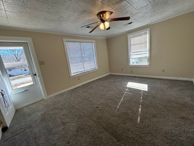
Bungalow 1947 style house with kitchen fully equipped with refrigerator, dishwasher, gas stove and stackable washer-dryer. Closet sizes are according to 1947 style home Huge yard 1 year lease minimum Credit score 550 minimum Background check required No felons Residential rental history No bankruptcies in last 5 years No active collections Income must be at least 3 x rental rate Proof of income is required Tenant is responsible for mowing lawn regularly, raking leaves, changing air filters monthly, replacing light bulbs
307 S Fairway Ave is a house located in Pulaski County and the 72120 ZIP Code. This area is served by the Pulaski County Special attendance zone.
* Price shown is base rent. Excludes user-selected optional fees and variable or usage-based fees and required charges due at or prior to move-in or at move-out. Price, availability, fees, and any applicable rent special are subject to change without notice.
* Square footage definitions vary. Displayed square footage is approximate.
Fees and Policies
The fees below are based on community-supplied data and may exclude additional fees and utilities.
-
One-Time Basics
-
Due at Move-In
-
Security Deposit - RefundableCharged per unit.$875
-
-
Due at Move-In
Property Fee Disclaimer: Based on community-supplied data and independent market research. Subject to change without notice. May exclude fees for mandatory or optional services and usage-based utilities.
House Features
- Dishwasher
Contact
- Listed by McKimmey Associates, Realtors | McKimmey Associates, Realtors
- Phone Number
- Contact
Location
Get Directions
Amenities
- Dishwasher
Jacksonville/Sherwood is a wooded area about 15 miles north of Little Rock. The community’s northern and western regions are mostly rural, but the town has a lot to offer. Jacksonville/ Sherwood has a diverse rental market with an abundance of affordable rental options. Modern amenities are located within and right outside of town, giving residents plenty of shopping and dining choices at places like McCain Mall and Lakewood Village. Outdoor recreation is abundant with forested parks and trails as well as the ones surrounding the Arkansas River. Commuters will appreciate Interstate 40 and Highway 167, which make traveling a breeze.
Learn more about living in Jacksonville/Sherwood
Education
| Colleges & Universities | Distance | ||
|---|---|---|---|
| Colleges & Universities | Distance | ||
| Drive: | 15 min | 6.7 mi | |
| Drive: | 15 min | 8.1 mi | |
| Drive: | 19 min | 9.8 mi | |
| Drive: | 23 min | 12.8 mi |
307 S Fairway Ave is within 15 minutes or 6.7 miles from Pulaski Technical College. It is also near Philander Smith College and Univ. of Ark. Medical Scis..
Schools


Public Elementary School
Grades PK-5
368 Students
Attendance Zone
Public Middle School
Grades 6-8
1,122 Students
Attendance Zone
Public High School
Grades 9-12
1,017 Students
Attendance Zone
Private Elementary & Middle School
Grades PK-8
373 Students
Nearby
Private Elementary, Middle & High School
Grades PK-12
268 Students
Nearby
School data provided by
 The GreatSchools Rating helps parents compare schools within a state based on a variety of school quality indicators and provides a helpful picture of how effectively each school serves all of its students. Ratings are on a scale of 1 (below average) to 10 (above average) and can include test scores, college readiness, academic progress, advanced courses, equity, discipline and attendance data. We also advise parents to visit schools, consider other information on school performance and programs, and consider family needs as part of the school selection process.
View GreatSchools Rating Methodology
Data provided by GreatSchools.org © 2026. All rights reserved.
View GreatSchools Rating Methodology
Data provided by GreatSchools.org © 2026. All rights reserved.
Transportation options available in Sherwood include Main St & Bishop Lindsey Ave, located 5.8 miles from 307 S Fairway Ave. 307 S Fairway Ave is near Bill and Hillary Clinton Ntl/Adams Field, located 12.6 miles or 20 minutes away.
| Transit / Subway | Distance | ||
|---|---|---|---|
| Transit / Subway | Distance | ||
| Drive: | 11 min | 5.8 mi | |
| Drive: | 11 min | 5.9 mi | |
| Drive: | 11 min | 5.9 mi | |
| Drive: | 11 min | 6.1 mi | |
| Drive: | 11 min | 6.1 mi |
| Commuter Rail | Distance | ||
|---|---|---|---|
| Commuter Rail | Distance | ||
|
|
Drive: | 14 min | 7.5 mi |
| Airports | Distance | ||
|---|---|---|---|
| Airports | Distance | ||
|
Bill and Hillary Clinton Ntl/Adams Field
|
Drive: | 20 min | 12.6 mi |
Time and distance from 307 S Fairway Ave.
| Shopping Centers | Distance | ||
|---|---|---|---|
| Shopping Centers | Distance | ||
| Walk: | 17 min | 0.9 mi | |
| Drive: | 3 min | 1.3 mi | |
| Drive: | 4 min | 1.9 mi |
307 S Fairway Ave has 3 shopping centers within 1.9 miles, which is about a 4-minute drive. The miles and minutes will be for the farthest away property.
| Parks and Recreation | Distance | ||
|---|---|---|---|
| Parks and Recreation | Distance | ||
|
Museum of Discovery
|
Drive: | 13 min | 6.9 mi |
|
Central Arkansas Nature Center
|
Drive: | 13 min | 6.9 mi |
|
Burns Park
|
Drive: | 14 min | 7.3 mi |
|
Central High School National Historic Site
|
Drive: | 18 min | 9.1 mi |
|
Little Rock Zoo
|
Drive: | 19 min | 11.1 mi |
307 S Fairway Ave has 5 parks within 11.1 miles, including Burns Park, Museum of Discovery, and Central Arkansas Nature Center.
| Hospitals | Distance | ||
|---|---|---|---|
| Hospitals | Distance | ||
| Walk: | 20 min | 1.1 mi | |
| Drive: | 8 min | 4.1 mi | |
| Drive: | 16 min | 8.2 mi |
307 S Fairway Ave has 3 hospitals within 8.2 miles, the nearest is St. Vincent Medical Center North which is 1.1 miles away and a 20 minute walk.
| Military Bases | Distance | ||
|---|---|---|---|
| Military Bases | Distance | ||
| Drive: | 21 min | 10.9 mi | |
| Drive: | 33 min | 12.3 mi | |
| Drive: | 40 min | 27.1 mi |
307 S Fairway Ave has 3 military bases within 27.1 miles, the nearest is Little Rock Air Force Base which is 10.9 miles away and a 21 minute drive.
You May Also Like
Similar Rentals Nearby


What Are Walk Score®, Transit Score®, and Bike Score® Ratings?
Walk Score® measures the walkability of any address. Transit Score® measures access to public transit. Bike Score® measures the bikeability of any address.
What is a Sound Score Rating?
A Sound Score Rating aggregates noise caused by vehicle traffic, airplane traffic and local sources
307 S Fairway Ave
Sherwood, AR 72120