


$3,800
/ Month
306 Ashton Way
Pleasant Hill, CA 94523
2 Weeks Ago
|
Edit
Favorites
306 Ashton Way

Favorites
Check Back Soon for Upcoming Availability
| Beds | Baths | Average SF |
|---|---|---|
| 3 Bedrooms 3 Bedrooms 3 Br | 2 Baths 2 Baths 2 Ba | 2,000 SF |
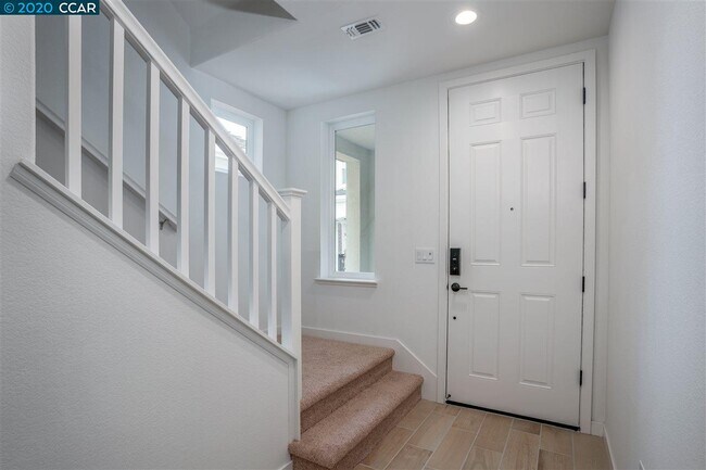
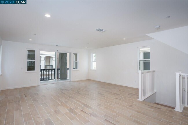
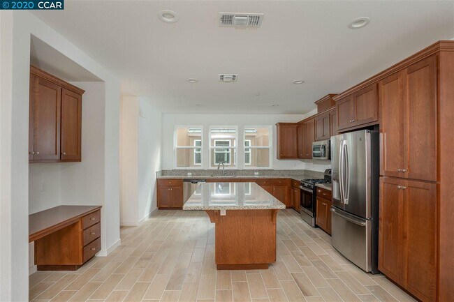
About This Property
According to CCAR guidelines, residential viewings may only occur virtually, or if virtual viewing is not feasible and the residence is unoccupied, (306 Ashton Way is Vacant) by appointment only with no more than two visitors from the same household and one person showing the unit. All parties to sign/DocuSign and submit to Listing Agent, Tom Stack via email the Coronavirus Property Entry Advisory and Declaration (form PEAD) prior to any showing and all parties to follow suggested sanitation guidelines. Submit to Tom.Stack@cbnorcal.com
306 Ashton Way is a house located in Contra Costa County and the 94523 ZIP Code. This area is served by the Mt. Diablo Unified attendance zone.
Location
Get Directions
The city of Concord exhibits all the character, charm, and natural beauty you’d expect of the Bay Area. South Concord, stretching from Clayton Road down towards Walnut Creek, provides renters with all of the appeal of the city in a more livable, affordable setting.
This vibrant suburban area houses a variety of rentals sandwiched between Lime Ride Open Space and Sunvalley Shopping Center. If you want value and space in a palm-tree-adorned atmopshere, look no further. Perfect for commuters thanks to I-680 to the west, South Concord provides families with a picturesque setting near the conveniences of the city, and the culture of the Bay Area.
Learn more about living in South ConcordBelow are rent ranges for similar nearby apartments
| Beds | Average Size | Lowest | Typical | Premium |
|---|---|---|---|---|
| Studio Studio Studio | 443 Sq Ft | $1,695 | $1,978 | $2,910 |
| 1 Bed 1 Bed 1 Bed | 658-659 Sq Ft | $1,200 | $2,246 | $7,476 |
| 2 Beds 2 Beds 2 Beds | 953-954 Sq Ft | $1,914 | $2,772 | $8,030 |
| 3 Beds 3 Beds 3 Beds | 1156-1164 Sq Ft | $2,373 | $3,145 | $4,709 |
| 4 Beds 4 Beds 4 Beds | 1633 Sq Ft | $3,595 | $4,019 | $4,900 |
Education
| Colleges & Universities | Distance | ||
|---|---|---|---|
| Colleges & Universities | Distance | ||
| Drive: | 9 min | 3.3 mi | |
| Drive: | 20 min | 9.3 mi | |
| Drive: | 27 min | 16.4 mi | |
| Drive: | 25 min | 17.1 mi |
306 Ashton Way is within 9 minutes or 3.3 miles from Diablo Valley, Pleasant Hill. It is also near Saint Marys Coll. of Calif. and Los Medanos College, Pittsburg.
Schools


Public Elementary School
Grades K-5
270 Students
Nearby
Public Elementary School
Grades K-5
317 Students
Attendance Zone
Public Middle School
Grades 6-8
700 Students
Attendance Zone
Public High School
Grades 9-12
1,172 Students
Attendance Zone
Private Elementary, Middle & High School
Grades PK-12
296 Students
Nearby
Private Elementary School
Grades K-6
Nearby
Private Elementary, Middle & High School
Grades 1-12
Nearby
School data provided by
 The GreatSchools Rating helps parents compare schools within a state based on a variety of school quality indicators and provides a helpful picture of how effectively each school serves all of its students. Ratings are on a scale of 1 (below average) to 10 (above average) and can include test scores, college readiness, academic progress, advanced courses, equity, discipline and attendance data. We also advise parents to visit schools, consider other information on school performance and programs, and consider family needs as part of the school selection process.
View GreatSchools Rating Methodology
Data provided by GreatSchools.org © 2026. All rights reserved.
View GreatSchools Rating Methodology
Data provided by GreatSchools.org © 2026. All rights reserved.
Transportation options available in Pleasant Hill include Pleasant Hill Station, located 0.9 mile from 306 Ashton Way. 306 Ashton Way is near Metro Oakland International, located 26.2 miles or 37 minutes away, and San Francisco International, located 38.2 miles or 55 minutes away.
| Transit / Subway | Distance | ||
|---|---|---|---|
| Transit / Subway | Distance | ||
|
|
Walk: | 16 min | 0.9 mi |
|
|
Drive: | 6 min | 2.6 mi |
|
|
Drive: | 8 min | 4.6 mi |
|
|
Drive: | 10 min | 6.2 mi |
|
|
Drive: | 9 min | 6.2 mi |
| Commuter Rail | Distance | ||
|---|---|---|---|
| Commuter Rail | Distance | ||
|
|
Drive: | 14 min | 10.1 mi |
|
|
Drive: | 27 min | 17.6 mi |
|
|
Drive: | 25 min | 18.9 mi |
|
|
Drive: | 27 min | 19.4 mi |
|
|
Drive: | 30 min | 21.3 mi |
| Airports | Distance | ||
|---|---|---|---|
| Airports | Distance | ||
|
Metro Oakland International
|
Drive: | 37 min | 26.2 mi |
|
San Francisco International
|
Drive: | 55 min | 38.2 mi |
Time and distance from 306 Ashton Way.
| Shopping Centers | Distance | ||
|---|---|---|---|
| Shopping Centers | Distance | ||
| Walk: | 5 min | 0.3 mi | |
| Walk: | 10 min | 0.5 mi | |
| Walk: | 18 min | 1.0 mi |
306 Ashton Way has 3 shopping centers within 1.0 mile, which is about a 18-minute walk. The miles and minutes will be for the farthest away property.
| Parks and Recreation | Distance | ||
|---|---|---|---|
| Parks and Recreation | Distance | ||
|
The Ruth Bancroft Garden
|
Drive: | 4 min | 1.8 mi |
|
Larkey Park
|
Drive: | 5 min | 1.9 mi |
|
Lindsay Wildlife Museum
|
Drive: | 5 min | 1.9 mi |
|
Heather Farm Park
|
Drive: | 6 min | 2.4 mi |
|
Gardens at Heather Farm
|
Drive: | 6 min | 2.6 mi |
306 Ashton Way has 5 parks within 2.6 miles, including Lindsay Wildlife Museum, Larkey Park, and The Ruth Bancroft Garden.
| Hospitals | Distance | ||
|---|---|---|---|
| Hospitals | Distance | ||
| Drive: | 5 min | 2.5 mi | |
| Drive: | 8 min | 3.4 mi | |
| Drive: | 8 min | 5.1 mi |
306 Ashton Way has 3 hospitals within 5.1 miles, the nearest is John Muir Medical Center - Walnut Creek Campus which is 2.5 miles away and a 5 minute drive.
You May Also Like
Similar Rentals Nearby


What Are Walk Score®, Transit Score®, and Bike Score® Ratings?
Walk Score® measures the walkability of any address. Transit Score® measures access to public transit. Bike Score® measures the bikeability of any address.
What is a Sound Score Rating?
A Sound Score Rating aggregates noise caused by vehicle traffic, airplane traffic and local sources

306 Ashton Way
Pleasant Hill, CA 94523