

$3,550
/ Month
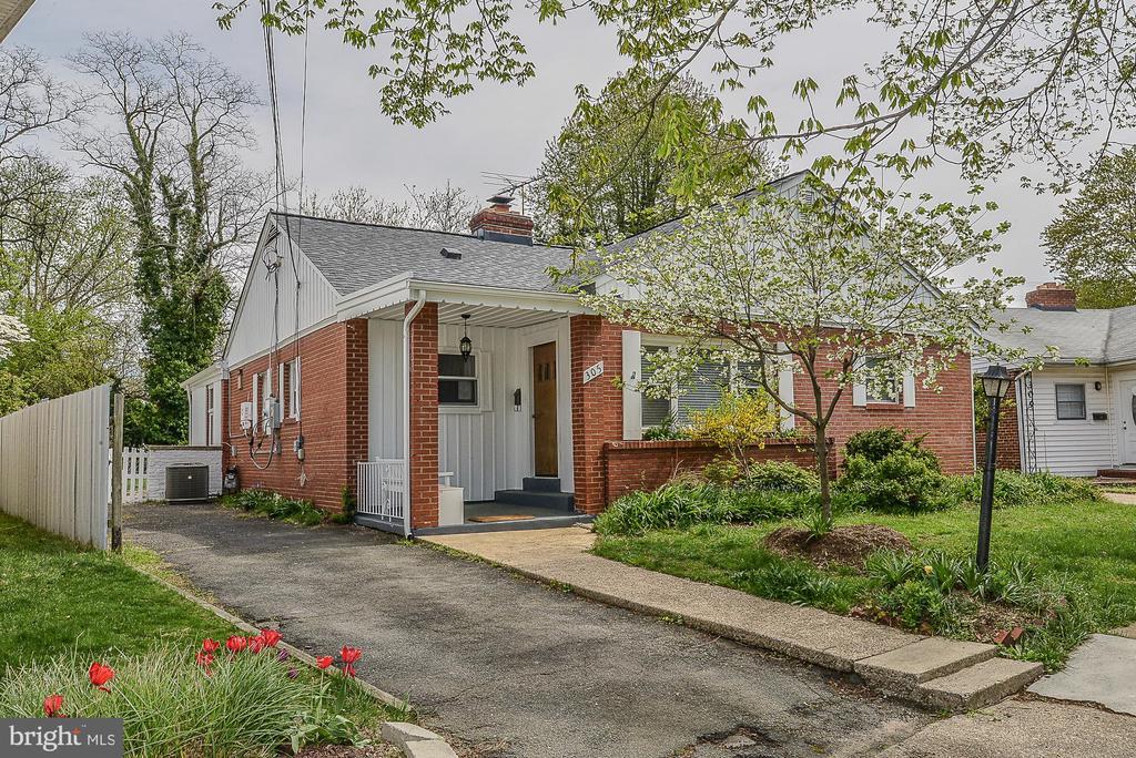
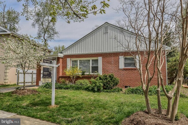
305 S Fenwick St
Arlington, VA 22204
Today
Favorites
703-307-8132
-
Bedrooms
4
-
Bathrooms
2
-
Square Feet
--
-
Available
Available Now
Highlights
- Rambler Architecture
- 1 Fireplace
- Solar Water Heater
- Ceramic Tile Flooring
- Luxury Vinyl Plank Tile Flooring
- Heating system powered by active solar
305 S Fenwick St

Favorites
About This Home
Available Now
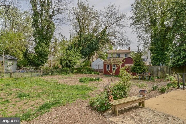
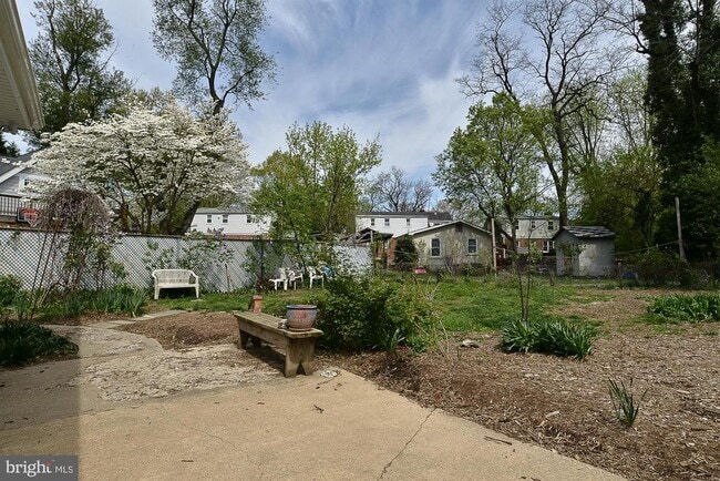
Charming home in Arlington Heights/Penrose. Close to many great Arlington amenities. Updates in 2019 include bathroom, floors, paint, and solar panels. This home has 3 bedrooms in the main living space, a very large bedroom in the back of the home, a large living room, a spacious kitchen, and a bonus room. There is a large yard and a cozy front porch. Close to Clarendon, Pentagon, and Rte 50. Tenants are responsible for all lawn care. ALL APPLICANTS MUST APPLY ON LINE AT: call agent for details. Please follow the directions on website and there is a non-refundable $50.00 application fee for anyone over 18. Tenant agrees to pay monthly rent utilizing tenant portal provided by KAPM or there will be a $3.95 fee for each personal check. Tenant agrees to enroll in Resident Benefit Package provided by Key Advantage PM that will provide furnace filters, assistance with utility set-up, renter’s insurance and other services (Cost is $44.95/month with renter’s insurance and $34.00/month without renter’s insurance).
305 S Fenwick St is a house located in Arlington County and the 22204 ZIP Code. This area is served by the Arlington County Public Schools attendance zone.
* Price shown is base rent. Excludes user-selected optional fees and variable or usage-based fees and required charges due at or prior to move-in or at move-out. Price, availability, fees, and any applicable rent special are subject to change without notice.
* Square footage definitions vary. Displayed square footage is approximate.
Home Details
Home Type
Single Family Detached Home
Year Built
Built in 1950
Bedrooms and Bathrooms
4 Main Level Bedrooms
2 Full Bathrooms
Eco-Friendly Details
Solar Water Heater
Heating system powered by active solar
Flooring
Ceramic Tile
Luxury Vinyl Plank Tile
Home Design
Rambler Architecture
Slab Foundation
Interior Spaces
1 Fireplace
1,637 Sq Ft Home
Property has 1 Level
Laundry
Laundry in unit
Listing and Financial Details
Security Deposit $3,750
12-Month Min and 24-Month Max Lease Term
Available 10/1/25
$50 Application Fee
Assessor Parcel Number 24-023-007
Tenant pays for cable TV, electricity, exterior maintenance, gas, heat, HVAC maintenance, internet, light bulbs/filters/fuses/alarm care, all utilities, windows/screens
No Smoking Allowed
Residential Lease
Lot Details
8,350 Sq Ft Lot
Property is in very good condition
Back Yard
Year Round Access
Property is zoned R-6
Parking
On-Street Parking
Off-Street Parking
Driveway
Utilities
90% Forced Air Heating and Cooling System
Community Details
Overview
No Home Owners Association
Property Manager
Arlington Heights Subdivision
Pet Policy
Dogs Allowed
Limit on the number of pets
Pet Deposit $500
Contact
- Listed by Michele F Symcak | CENTURY 21 Redwood Realty
- Phone Number
- Contact
-
Source
 Bright MLS, Inc.
Copyright © 2025 Bright MLS, Inc.
Location
Get Directions
Amenities
- Fireplace
With brick colonials along tree-lined streets, Arlington Heights is a popular historic neighborhood just south of Downtown Arlington. The picturesque neighborhood is listed on the National Register of Historic Places and contains more than 737 historic structures and sites.
Arlington Heights extends south from Arlington Boulevard to Columbia Pike. It is just west of Arlington National Cemetery between S. Walter Reed Drive and South Glebe Road. Located just over one mile from downtown, apartments in Arlington Heights offer easy access to Ballston Common Mall, the Pentagon, and Joint Base Myer-Henderson Hall.
Learn more about living in Arlington Heights
Education
| Colleges & Universities | Distance | ||
|---|---|---|---|
| Colleges & Universities | Distance | ||
| Drive: | 6 min | 1.8 mi | |
| Drive: | 7 min | 3.1 mi | |
| Drive: | 10 min | 4.1 mi | |
| Drive: | 8 min | 4.3 mi |
305 S Fenwick St is within 6 minutes or 1.8 miles from George Mason Univ., Arlington. It is also near NOVA, Alexandria Campus and Georgetown University.
Schools


Public Elementary School
Grades PK-5
614 Students
Attendance Zone
Public Middle School
Grades 6-8
1,053 Students
Attendance Zone
Public High School
Grades 9-12
2,766 Students
Attendance Zone
Private Elementary, Middle & High School
Grades PK-12
Nearby
Private Elementary & Middle School
Grades PK-8
398 Students
Nearby
School data provided by
 The GreatSchools Rating helps parents compare schools within a state based on a variety of school quality indicators and provides a helpful picture of how effectively each school serves all of its students. Ratings are on a scale of 1 (below average) to 10 (above average) and can include test scores, college readiness, academic progress, advanced courses, equity, discipline and attendance data. We also advise parents to visit schools, consider other information on school performance and programs, and consider family needs as part of the school selection process.
View GreatSchools Rating Methodology
Data provided by GreatSchools.org © 2025. All rights reserved.
View GreatSchools Rating Methodology
Data provided by GreatSchools.org © 2025. All rights reserved.
Transportation options available in Arlington include Clarendon, located 1.6 miles from 305 S Fenwick St. 305 S Fenwick St is near Ronald Reagan Washington Ntl, located 4.4 miles or 11 minutes away, and Washington Dulles International, located 23.6 miles or 40 minutes away.
| Transit / Subway | Distance | ||
|---|---|---|---|
| Transit / Subway | Distance | ||
|
|
Drive: | 5 min | 1.6 mi |
|
|
Drive: | 5 min | 1.8 mi |
|
|
Drive: | 5 min | 1.9 mi |
| Drive: | 4 min | 2.0 mi | |
|
|
Drive: | 5 min | 2.3 mi |
| Commuter Rail | Distance | ||
|---|---|---|---|
| Commuter Rail | Distance | ||
|
|
Drive: | 7 min | 3.0 mi |
|
|
Drive: | 10 min | 4.9 mi |
|
|
Drive: | 10 min | 4.9 mi |
|
|
Drive: | 14 min | 5.6 mi |
|
|
Drive: | 14 min | 5.6 mi |
| Airports | Distance | ||
|---|---|---|---|
| Airports | Distance | ||
|
Ronald Reagan Washington Ntl
|
Drive: | 11 min | 4.4 mi |
|
Washington Dulles International
|
Drive: | 40 min | 23.6 mi |
Time and distance from 305 S Fenwick St.
| Shopping Centers | Distance | ||
|---|---|---|---|
| Shopping Centers | Distance | ||
| Walk: | 11 min | 0.6 mi | |
| Walk: | 13 min | 0.7 mi | |
| Walk: | 13 min | 0.7 mi |
305 S Fenwick St has 3 shopping centers within 0.7 mile, which is about a 13-minute walk. The miles and minutes will be for the farthest away property.
| Parks and Recreation | Distance | ||
|---|---|---|---|
| Parks and Recreation | Distance | ||
|
Douglas Park
|
Drive: | 4 min | 1.6 mi |
|
Lubber Run Park
|
Drive: | 5 min | 2.0 mi |
|
Shirlington Park
|
Drive: | 6 min | 2.0 mi |
|
David M. Brown Planetarium
|
Drive: | 6 min | 2.2 mi |
|
Glencarlyn Park
|
Drive: | 8 min | 3.1 mi |
305 S Fenwick St has 5 parks within 3.1 miles, including Douglas Park, Lubber Run Park, and Glencarlyn Park.
| Hospitals | Distance | ||
|---|---|---|---|
| Hospitals | Distance | ||
| Drive: | 7 min | 2.5 mi | |
| Drive: | 8 min | 3.0 mi | |
| Drive: | 10 min | 4.0 mi |
305 S Fenwick St has 3 hospitals within 4.0 miles, the nearest is Capital Hospice which is 2.5 miles away and a 7 minute drive.
| Military Bases | Distance | ||
|---|---|---|---|
| Military Bases | Distance | ||
| Drive: | 3 min | 1.2 mi |
305 S Fenwick St is 1.2 miles and a 3 minute drive from Fort Myer.
You May Also Like
Similar Rentals Nearby


What Are Walk Score®, Transit Score®, and Bike Score® Ratings?
Walk Score® measures the walkability of any address. Transit Score® measures access to public transit. Bike Score® measures the bikeability of any address.
What is a Sound Score Rating?
A Sound Score Rating aggregates noise caused by vehicle traffic, airplane traffic and local sources

305 S Fenwick St
Arlington, VA 22204