
$3,700
/ Month
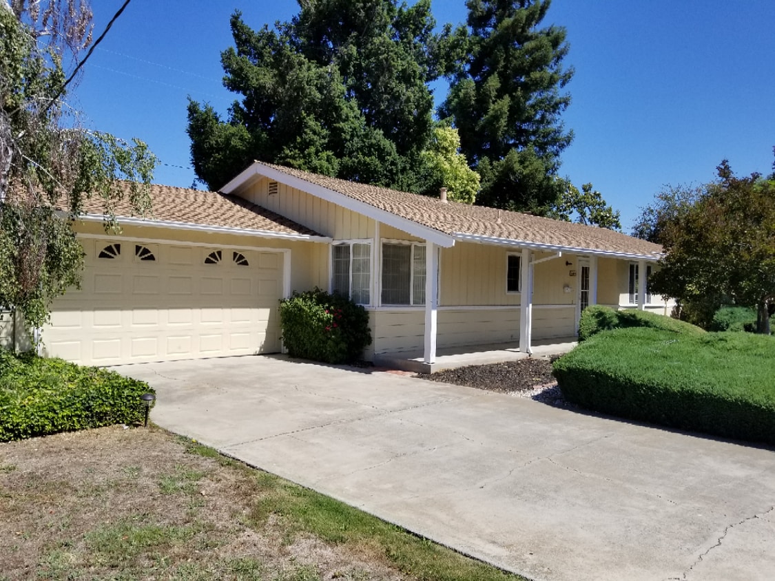
302 Los Felicas Ave
Walnut Creek, CA 94598
Today
|
Edit
Favorites
925-831-8970
-
Bedrooms
3
-
Bathrooms
2
-
Square Feet
1,400 sq ft
-
Available
Available Now
302 Los Felicas Ave

Favorites
About This Home
$3,600 deposit,
Available Now
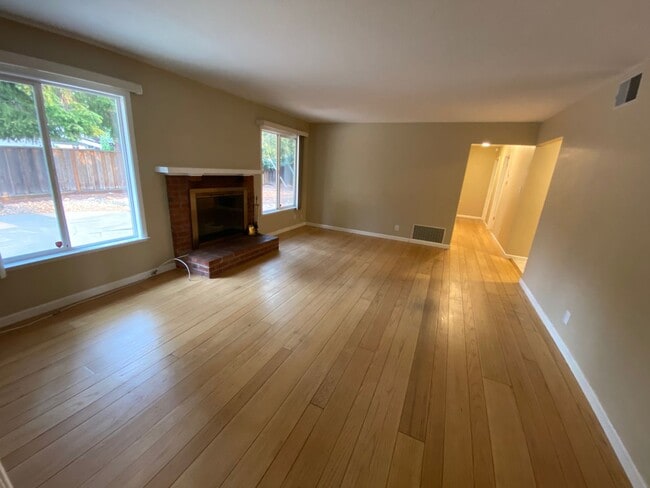
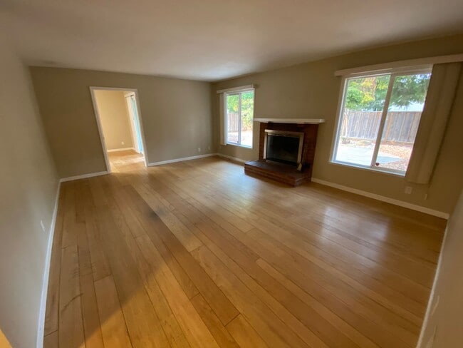
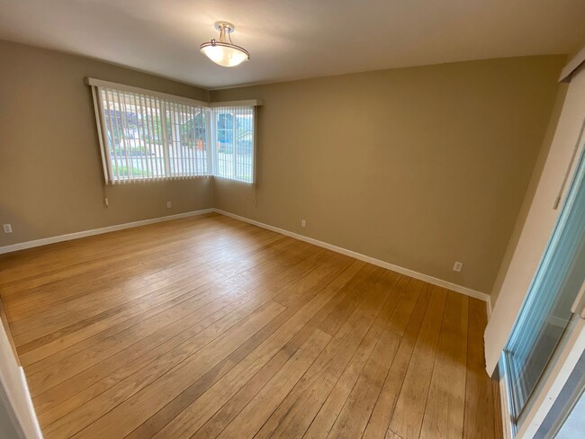
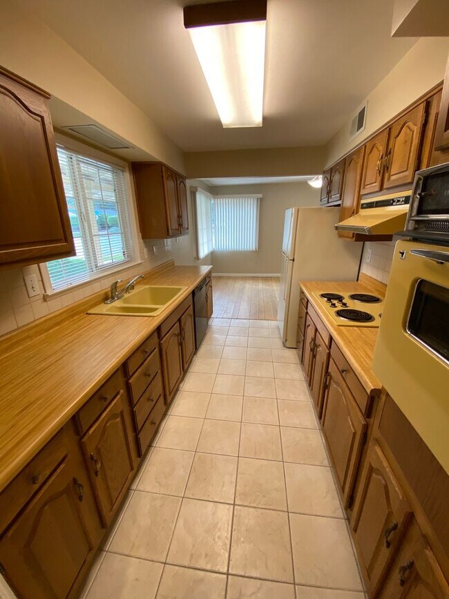
3 bed 2 bath, apx 1400 sq ft. Great Location off Ygnacio Valley Road near Heather Farms park. Corner lot. Hardwood floors and dual pane windows. Central air conditioning and forced air heating. Two car garage. Owner provides gardener.
Unique Features
- Forced Air Heating
- Two Car Garage
- Fireplace
- N/A
302 Los Felicas Ave is a house located in Contra Costa County and the 94598 ZIP Code. This area is served by the Mt. Diablo Unified attendance zone.
* Price shown is base rent. Excludes user-selected optional fees and variable or usage-based fees and required charges due at or prior to move-in or at move-out. Price, availability, fees, and any applicable rent special are subject to change without notice.
* Square footage definitions vary. Displayed square footage is approximate.
Fees and Policies
The fees below are based on community-supplied data and may exclude additional fees and utilities.
- One-Time Basics
- Due at Move-In
- Security Deposit - RefundableCharged per unit.$3,600
- Due at Move-In
Property Fee Disclaimer: Based on community-supplied data and independent market research. Subject to change without notice. May exclude fees for mandatory or optional services and usage-based utilities.
Contact
- Listed by Perchak Properties Inc. | Perchak Properties Inc.
- Phone Number
- Contact
Location
Get Directions
Amenities
- Forced Air Heating
- Two Car Garage
- Fireplace
- N/A
Nestled in the East Bay region of the San Francisco Bay Area, Walnut Creek combines suburban comfort with city amenities. The city encompasses 1,800 acres of open space, featuring Shell Ridge and Lime Ridge trails for hiking and outdoor recreation. Downtown Walnut Creek features Broadway Plaza shopping district, while the Lesher Center for the Arts hosts performances and cultural events. The rental market shows a 1.7% annual increase, with one-bedroom units averaging $2,476 and two-bedroom homes typically renting for $2,953. Notable areas include Parkmead, Walnut Heights, and the Northgate district.
Established in 1849 along what early settlers called "Nuts Creek," Walnut Creek has grown into a community of over 70,000 residents. The Mediterranean climate makes it ideal for exploring outdoor spaces like Heather Farm Park and the Ruth Bancroft Garden.
Learn more about living in Walnut Creek
Education
| Colleges & Universities | Distance | ||
|---|---|---|---|
| Colleges & Universities | Distance | ||
| Drive: | 14 min | 5.4 mi | |
| Drive: | 22 min | 9.1 mi | |
| Drive: | 27 min | 14.8 mi | |
| Drive: | 29 min | 16.6 mi |
302 Los Felicas Ave is within 14 minutes or 5.4 miles from Diablo Valley, Pleasant Hill. It is also near Saint Marys Coll. of Calif. and Los Medanos College, Pittsburg.
Schools


Public Elementary School
Grades K-5
638 Students
Attendance Zone
Public Elementary School
Grades K-5
497 Students
Nearby
Public Middle School
Grades 6-8
876 Students
Attendance Zone
Public High School
Grades 9-12
1,507 Students
Attendance Zone
Private High School
Grades 9-12
418 Students
Nearby
School data provided by
 The GreatSchools Rating helps parents compare schools within a state based on a variety of school quality indicators and provides a helpful picture of how effectively each school serves all of its students. Ratings are on a scale of 1 (below average) to 10 (above average) and can include test scores, college readiness, academic progress, advanced courses, equity, discipline and attendance data. We also advise parents to visit schools, consider other information on school performance and programs, and consider family needs as part of the school selection process.
View GreatSchools Rating Methodology
Data provided by GreatSchools.org © 2025. All rights reserved.
View GreatSchools Rating Methodology
Data provided by GreatSchools.org © 2025. All rights reserved.
Transportation options available in Walnut Creek include Pleasant Hill Station, located 2.4 miles from 302 Los Felicas Ave. 302 Los Felicas Ave is near Metro Oakland International, located 26.4 miles or 39 minutes away, and San Francisco International, located 38.4 miles or 57 minutes away.
| Transit / Subway | Distance | ||
|---|---|---|---|
| Transit / Subway | Distance | ||
|
|
Drive: | 6 min | 2.4 mi |
|
|
Drive: | 7 min | 2.7 mi |
|
|
Drive: | 13 min | 5.7 mi |
|
|
Drive: | 11 min | 6.4 mi |
|
|
Drive: | 14 min | 7.8 mi |
| Commuter Rail | Distance | ||
|---|---|---|---|
| Commuter Rail | Distance | ||
|
|
Drive: | 19 min | 11.7 mi |
|
|
Drive: | 28 min | 17.3 mi |
|
|
Drive: | 29 min | 17.8 mi |
|
|
Drive: | 28 min | 19.6 mi |
|
|
Drive: | 32 min | 21.5 mi |
| Airports | Distance | ||
|---|---|---|---|
| Airports | Distance | ||
|
Metro Oakland International
|
Drive: | 39 min | 26.4 mi |
|
San Francisco International
|
Drive: | 57 min | 38.4 mi |
Time and distance from 302 Los Felicas Ave.
| Shopping Centers | Distance | ||
|---|---|---|---|
| Shopping Centers | Distance | ||
| Walk: | 12 min | 0.7 mi | |
| Drive: | 4 min | 1.7 mi | |
| Drive: | 5 min | 1.9 mi |
302 Los Felicas Ave has 3 shopping centers within 1.9 miles, which is about a 5-minute walk. The miles and minutes will be for the farthest away property.
| Parks and Recreation | Distance | ||
|---|---|---|---|
| Parks and Recreation | Distance | ||
|
The Ruth Bancroft Garden
|
Walk: | 15 min | 0.8 mi |
|
Heather Farm Park
|
Walk: | 17 min | 0.9 mi |
|
Gardens at Heather Farm
|
Walk: | 20 min | 1.1 mi |
|
Arbolado Park
|
Drive: | 6 min | 2.3 mi |
|
Howe Homestead Park
|
Drive: | 8 min | 2.8 mi |
302 Los Felicas Ave has 5 parks within 2.8 miles, including The Ruth Bancroft Garden, Heather Farm Park, and Gardens at Heather Farm.
| Hospitals | Distance | ||
|---|---|---|---|
| Hospitals | Distance | ||
| Walk: | 23 min | 1.2 mi | |
| Drive: | 8 min | 3.2 mi | |
| Drive: | 13 min | 6.8 mi |
302 Los Felicas Ave has 3 hospitals within 6.8 miles, the nearest is John Muir Medical Center - Walnut Creek Campus which is 1.2 miles away and a 23 minute walk.
You May Also Like
Similar Rentals Nearby


What Are Walk Score®, Transit Score®, and Bike Score® Ratings?
Walk Score® measures the walkability of any address. Transit Score® measures access to public transit. Bike Score® measures the bikeability of any address.
What is a Sound Score Rating?
A Sound Score Rating aggregates noise caused by vehicle traffic, airplane traffic and local sources

302 Los Felicas Ave
Walnut Creek, CA 94598