

$3,200
/ Month
3006 N 34th St
Phoenix, AZ 85018
Today
|
Edit
Favorites
617-304-0075
-
Bedrooms
3
-
Bathrooms
2.5
-
Square Feet
1,783 sq ft
-
Available
Available Now
3006 N 34th St

Favorites
About This Home
Available Now
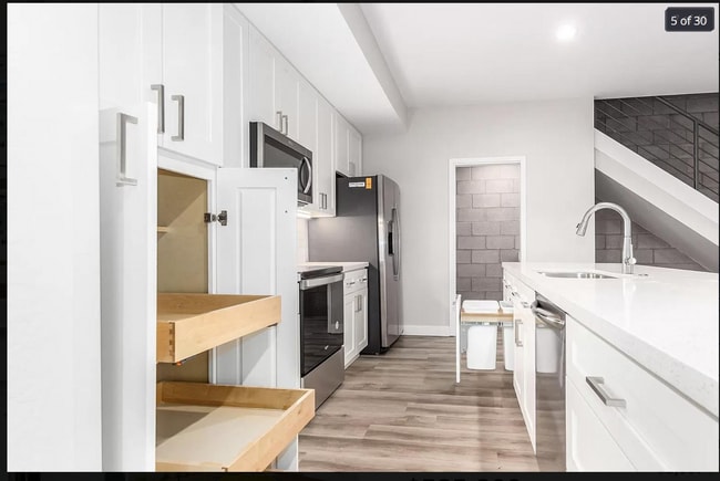
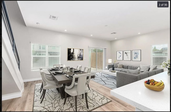
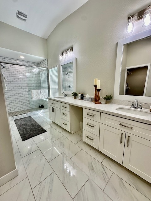
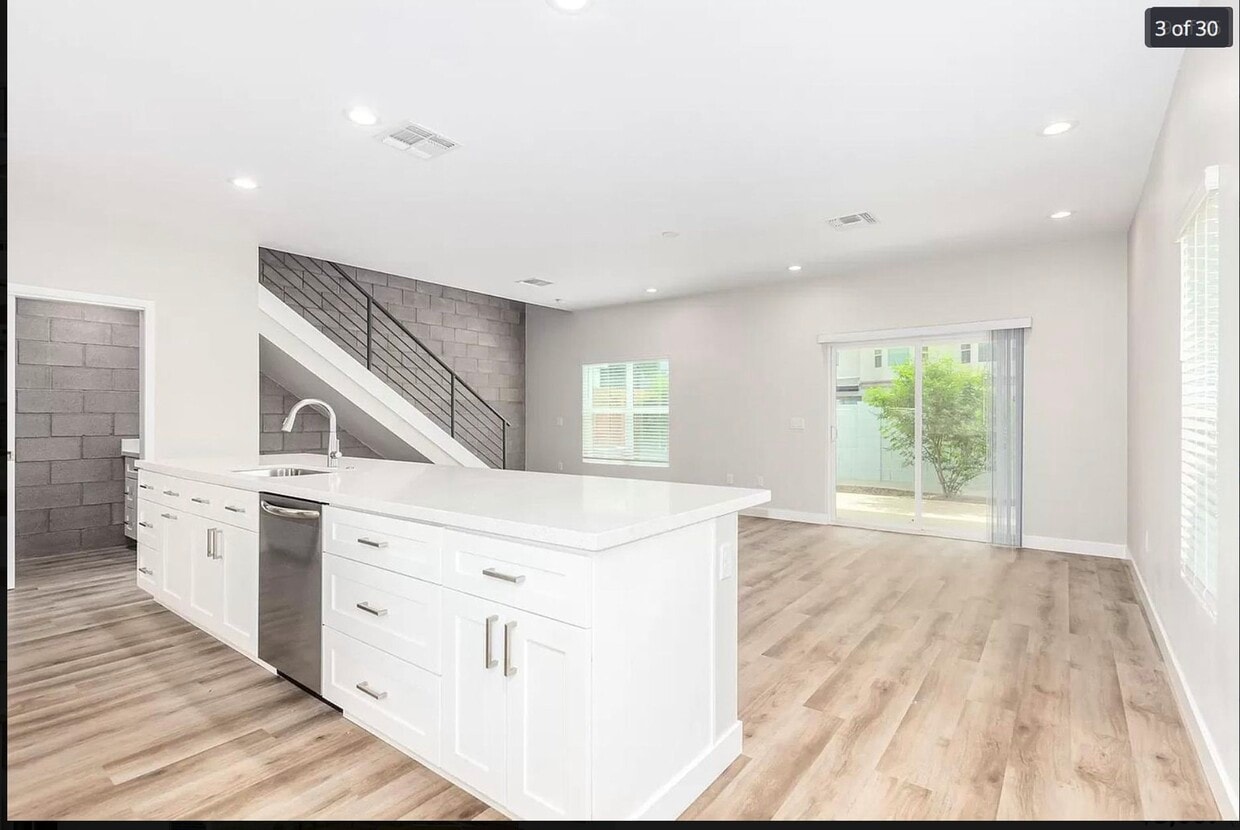
3 bedrooms , 2.5 Baths Townhouse with Private Backyard, 2 car Garage Attached. Modern Finishes. Private Dog Park.Renter is Responsible for Utilities: Water and Trash(City of Phoenix), Electric(SRP), Internet/TV
3006 N 34Th St is a townhome located in Maricopa County and the 85018 ZIP Code. This area is served by the Creighton Elementary District attendance zone.
* Price shown is base rent. Excludes user-selected optional fees and variable or usage-based fees and required charges due at or prior to move-in or at move-out. Price, availability, fees, and any applicable rent special are subject to change without notice.
* Square footage definitions vary. Displayed square footage is approximate.
Fees and Policies
The fees listed below are community-provided and may exclude utilities or add-ons. All payments are made directly to the property and are non-refundable unless otherwise specified.
-
Dogs
-
Allowed
-
-
Cats
-
Allowed
-
Property Fee Disclaimer: Based on community-supplied data and independent market research. Subject to change without notice. May exclude fees for mandatory or optional services and usage-based utilities.
Townhome Features
Washer/Dryer
Walk-In Closets
Tile Floors
Carpet
- Washer/Dryer
- Carpet
- Tile Floors
- Walk-In Closets
- Pet Play Area
- Fenced Lot
Contact
- Listed by Miad Vakili
- Phone Number
- Contact
Location
Get Directions
East Phoenix, also known as Camelback East, is a vibrant suburb situated between Old Town Scottsdale and Downtown Phoenix. The neighborhood is teeming with a wide variety of shopping and dining options in numerous plazas and shopping centers along East Camelback Road, East Indian School Road, and Thomas Road.
Outdoor destinations like Phoenix Mountains Preserve, Echo Canyon Recreation Area, Papago Park, and Tempe Beach Park are all located within minutes of East Phoenix, providing ample opportunities to enjoy the area’s natural beauty. Traveling and commuting from East Phoenix is easy with access to Phoenix Sky Harbor International Airport and multiple major freeways.
Learn more about living in East Phoenix
Amenities
- Washer/Dryer
- Carpet
- Tile Floors
- Walk-In Closets
- Pet Play Area
- Fenced Lot
Education
| Colleges & Universities | Distance | ||
|---|---|---|---|
| Colleges & Universities | Distance | ||
| Drive: | 7 min | 3.1 mi | |
| Drive: | 11 min | 5.1 mi | |
| Drive: | 9 min | 5.4 mi | |
| Drive: | 10 min | 5.7 mi |
3006 N 34th St is within 7 minutes or 3.1 miles from Gateway Community College. It is also near Phoenix College and University of Arizona.
Schools


Public Elementary & Middle School
Grades PK-8
822 Students
Nearby
Public Elementary & Middle School
Grades PK-8
795 Students
Attendance Zone
Public High School
Grades 9-12
2,238 Students
Attendance Zone
Private Elementary, Middle & High School
Grades 1-12
274 Students
Nearby
Private Elementary & Middle School
Grades PK-9
Nearby
Private Elementary & Middle School
Grades PK-8
141 Students
Nearby
School data provided by
 The GreatSchools Rating helps parents compare schools within a state based on a variety of school quality indicators and provides a helpful picture of how effectively each school serves all of its students. Ratings are on a scale of 1 (below average) to 10 (above average) and can include test scores, college readiness, academic progress, advanced courses, equity, discipline and attendance data. We also advise parents to visit schools, consider other information on school performance and programs, and consider family needs as part of the school selection process.
View GreatSchools Rating Methodology
Data provided by GreatSchools.org © 2026. All rights reserved.
View GreatSchools Rating Methodology
Data provided by GreatSchools.org © 2026. All rights reserved.
Transportation options available in Phoenix include 38Th St/Washington, located 3.4 miles from 3006 N 34th St. 3006 N 34th St is near Phoenix Sky Harbor International, located 6.5 miles or 12 minutes away, and Phoenix-Mesa Gateway, located 31.3 miles or 45 minutes away.
| Transit / Subway | Distance | ||
|---|---|---|---|
| Transit / Subway | Distance | ||
|
|
Drive: | 6 min | 3.4 mi |
|
|
Drive: | 6 min | 3.6 mi |
|
|
Drive: | 7 min | 3.6 mi |
|
|
Drive: | 7 min | 3.7 mi |
| Drive: | 8 min | 3.9 mi |
| Commuter Rail | Distance | ||
|---|---|---|---|
| Commuter Rail | Distance | ||
|
|
Drive: | 45 min | 32.7 mi |
| Airports | Distance | ||
|---|---|---|---|
| Airports | Distance | ||
|
Phoenix Sky Harbor International
|
Drive: | 12 min | 6.5 mi |
|
Phoenix-Mesa Gateway
|
Drive: | 45 min | 31.3 mi |
Time and distance from 3006 N 34th St.
| Shopping Centers | Distance | ||
|---|---|---|---|
| Shopping Centers | Distance | ||
| Walk: | 4 min | 0.2 mi | |
| Walk: | 7 min | 0.4 mi | |
| Walk: | 9 min | 0.5 mi |
3006 N 34th St has 3 shopping centers within 0.5 mile, which is about a 9-minute walk. The miles and minutes will be for the farthest away property.
| Parks and Recreation | Distance | ||
|---|---|---|---|
| Parks and Recreation | Distance | ||
|
Tonto National Forest
|
Drive: | 5 min | 2.2 mi |
|
Arcadia Park
|
Drive: | 7 min | 3.7 mi |
|
Steele Indian School Park
|
Drive: | 9 min | 4.5 mi |
|
Eastlake Park
|
Drive: | 9 min | 4.9 mi |
|
Desert Storm Park
|
Drive: | 11 min | 5.9 mi |
3006 N 34th St has 5 parks within 5.9 miles, including Tonto National Forest, Arcadia Park, and Steele Indian School Park.
| Hospitals | Distance | ||
|---|---|---|---|
| Hospitals | Distance | ||
| Walk: | 4 min | 0.2 mi | |
| Drive: | 4 min | 2.1 mi | |
| Drive: | 5 min | 2.5 mi |
3006 N 34th St has 3 hospitals within 2.5 miles, the nearest is Valley Hospital which is 0.2 mile away and a 4 minute walk.
| Military Bases | Distance | ||
|---|---|---|---|
| Military Bases | Distance | ||
| Drive: | 14 min | 6.6 mi | |
| Drive: | 36 min | 26.3 mi | |
| Drive: | 103 min | 78.8 mi |
3006 N 34th St has 3 military bases within 78.8 miles, the nearest is Phoenix Sky Harbor Airport Air Guard Station which is 6.6 miles away and a 14 minute drive.
You May Also Like
Similar Rentals Nearby
-
-
-
-
-
-
-
-
-
-
3 Beds$2,453+Total Monthly PriceTotal Monthly Price NewPrices include base rent and required monthly fees of $33. Variable costs based on usage may apply.Base Rent:3 Beds$2,420+1 Month Free
Pets Allowed Fitness Center Pool Dishwasher In Unit Washer & Dryer Clubhouse Stainless Steel Appliances


What Are Walk Score®, Transit Score®, and Bike Score® Ratings?
Walk Score® measures the walkability of any address. Transit Score® measures access to public transit. Bike Score® measures the bikeability of any address.
What is a Sound Score Rating?
A Sound Score Rating aggregates noise caused by vehicle traffic, airplane traffic and local sources
3006 N 34th St
Phoenix, AZ 85018