
$3,000 / Month
30 Peterborough St Unit 26
Boston, MA 02215
Today
Favorites
774-329-1666
-
Bedrooms
1
-
Bathrooms
1
-
Square Feet
647 sq ft
-
Available
Available Aug 15
Highlights
- Medical Services
- Deck
- Property is near public transit
- No Cooling
- Park
- Shops
30 Peterborough St Unit 26

Favorites
About This Home
$3,000 deposit,
Available Aug 15
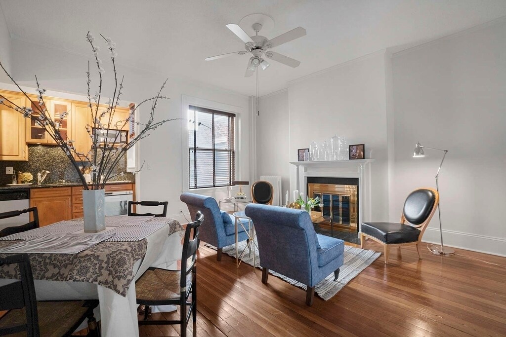
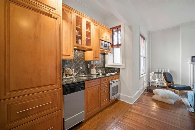
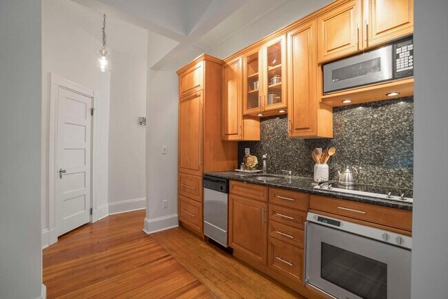
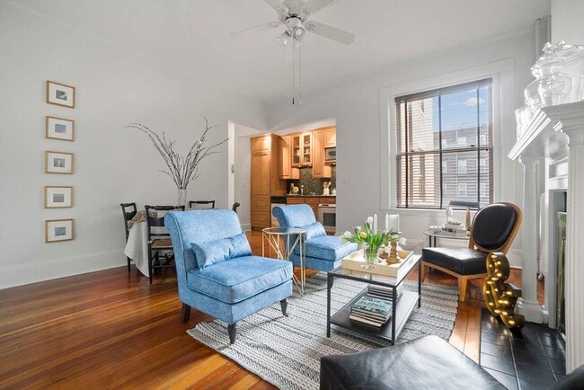
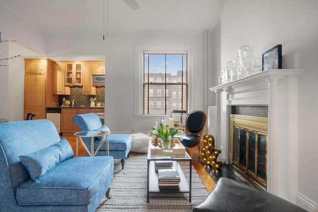
Welcome to this charming 647 sqft 1-bedroom apartment at 30 Peterborough St,nestled in the heart of Boston’s vibrant Fenway neighborhood. This well-maintained second-floor unit boasts an efficient layout,abundant natural light,and beautiful 10’ ceilings with a decorative fireplace. The oversized bedroom features two large windows,a generous closet,and space for a desk or sitting area. The kitchen is fully equipped with a SubZero fridge,granite counters,maple cabinets,stove,dishwasher,microwave,and disposal. Rent includes heat,hot water,and a rare dedicated parking space. Enjoy a professionally managed building with on-site laundry,basement storage,and a shared rooftop deck—perfect for relaxing or entertaining. Located on a quiet,tree-lined street just steps from public transit,Longwood Medical,BU,Northeastern,Wentworth,MassArt,Fenway Park,museums,restaurants,and shopping. Ideal for a professional or grad student seeking comfort and convenience. MLS# 73395102
30 Peterborough St is a condo located in Suffolk County and the 02215 ZIP Code.
* Price shown is base rent and may not include non-optional fees and utilities.
Price, availability, fees, and any applicable rent special are subject to change without notice.
* Square footage definitions vary. Displayed square footage is approximate.
Home Details
Home Type
Condominium
Year Built
Built in 1900
Accessible Home Design
Entry on the 2nd floor
Bedrooms and Bathrooms
1 Full Bathroom
1 Bedroom
Interior Spaces
647 Sq Ft Home
Kitchen
Range
Microwave
Dishwasher
Listing and Financial Details
Security Deposit $3,000
Property Available on 8/15/25
Assessor Parcel Number W:05 P:04236 S:094,3347657
Rent includes heat, hot water, water, snow removal, parking
Location
Property is near public transit
Property is near schools
Lot Details
2.3 Acre Lot
Outdoor Features
Deck
Parking
1 Car Parking Space
Utilities
No Cooling
Community Details
Amenities
Medical Services
Shops
Laundry Facilities
Overview
Property has a Home Owners Association
Pet Policy
Call for details about the types of pets allowed
Recreation
Park
Fees and Policies
The fees below are based on community-supplied data and may exclude additional fees and utilities.
Pet policies are negotiable.
Contact
- Listed by Tiesong Ma | United Real Estate,LLC
- Phone Number
-
Source
 MLS Property Information Network
The property listing data and information set forth herein were provided to MLS Property Information Network, Inc. from third party sources, including sellers, lessors and public records, and were compiled by MLS Property Information Network, Inc. The property listing data and information are for the personal, non-commercial use of consumers having a good faith interest in purchasing or leasing listed properties of the type displayed to them and may not be used for any purpose other than to identify prospective properties which such consumers may have a good faith interest in purchasing or leasing. MLS Property Information Network, Inc. and its subscribers disclaim any and all representations and warranties as to the accuracy of the property listing data and information set forth herein. All properties are subject to prior sale, change or withdrawal. Copyright © 2025 MLS Property Information Network, Inc. All rights reserved.
Location
Get Directions
Amenities
- Dishwasher
- Microwave
- Range
- Refrigerator
- Deck
Tree-filled, historic, and packed with educational opportunity, there's no other neighborhood quite like Fenway. The neighborhood may be most well-known for its titular attraction, Fenway Park, home of the Boston Red Sox. However, the area is also renowned for its sprawling greenspace. The name "Fenway" refers to the neighborhood’s lush parkway and tree-filled paths that wind lazily through the area, forming part of Frederick Law Olmsted’s “Emerald Necklace Plan” (a chain of parks throughout Boston). The Fenway opened in 1876, and its route includes the Museum of Fine Arts and the Isabella Steward Gardner Museum.
Learn more about living in Fenway
Education
| Colleges & Universities | Distance | ||
|---|---|---|---|
| Colleges & Universities | Distance | ||
| Walk: | 10 min | 0.6 mi | |
| Walk: | 11 min | 0.6 mi | |
| Walk: | 12 min | 0.6 mi | |
| Walk: | 12 min | 0.7 mi |
30 Peterborough St Unit 26 is within 10 minutes or 0.6 mile from Lesley Univ., Art Institute. It is also near Simmons College and Emmanuel College.
Transportation options available in Boston include Kenmore Station, located 0.5 mile from 30 Peterborough St Unit 26. 30 Peterborough St Unit 26 is near General Edward Lawrence Logan International, located 6.3 miles or 14 minutes away.
| Transit / Subway | Distance | ||
|---|---|---|---|
| Transit / Subway | Distance | ||
|
|
Walk: | 10 min | 0.5 mi |
|
|
Walk: | 11 min | 0.6 mi |
|
|
Walk: | 11 min | 0.6 mi |
|
|
Walk: | 12 min | 0.6 mi |
|
|
Drive: | 3 min | 1.2 mi |
| Commuter Rail | Distance | ||
|---|---|---|---|
| Commuter Rail | Distance | ||
|
|
Walk: | 16 min | 0.9 mi |
|
|
Drive: | 7 min | 1.7 mi |
| Drive: | 6 min | 2.2 mi | |
|
|
Drive: | 8 min | 2.5 mi |
|
|
Drive: | 8 min | 4.1 mi |
| Airports | Distance | ||
|---|---|---|---|
| Airports | Distance | ||
|
General Edward Lawrence Logan International
|
Drive: | 14 min | 6.3 mi |
Time and distance from 30 Peterborough St Unit 26.
| Shopping Centers | Distance | ||
|---|---|---|---|
| Shopping Centers | Distance | ||
| Walk: | 5 min | 0.3 mi | |
| Walk: | 15 min | 0.8 mi | |
| Drive: | 9 min | 5.0 mi |
30 Peterborough St Unit 26 has 3 shopping centers within 5.0 miles, which is about a 9-minute walk. The miles and minutes will be for the farthest away property.
| Parks and Recreation | Distance | ||
|---|---|---|---|
| Parks and Recreation | Distance | ||
|
Charles River Reservation
|
Drive: | 3 min | 1.2 mi |
|
Coit Observatory
|
Drive: | 3 min | 1.4 mi |
|
Boston Public Garden
|
Drive: | 6 min | 2.0 mi |
|
Roxbury Heritage State Park
|
Drive: | 5 min | 2.0 mi |
|
John Fitzgerald Kennedy National Historic Site
|
Drive: | 5 min | 2.0 mi |
30 Peterborough St Unit 26 has 5 parks within 2.0 miles, including Charles River Reservation, Coit Observatory, and Roxbury Heritage State Park.
| Hospitals | Distance | ||
|---|---|---|---|
| Hospitals | Distance | ||
| Walk: | 11 min | 0.6 mi | |
| Walk: | 15 min | 0.8 mi | |
| Drive: | 3 min | 1.3 mi |
30 Peterborough St Unit 26 has 3 hospitals within 1.3 miles, the nearest is Beth Israel Deaconess Medical Center which is 0.6 mile away and a 11 minute walk.
| Military Bases | Distance | ||
|---|---|---|---|
| Military Bases | Distance | ||
| Drive: | 29 min | 14.8 mi | |
| Drive: | 28 min | 15.8 mi |
30 Peterborough St Unit 26 is 14.8 miles from Hanscom Air Force Base, and is convenient to other military bases, including US Military Reservation.
You May Also Like
Similar Rentals Nearby
-
-

-

-

-
-
1 / 24

-
-
-

-


What Are Walk Score®, Transit Score®, and Bike Score® Ratings?
Walk Score® measures the walkability of any address. Transit Score® measures access to public transit. Bike Score® measures the bikeability of any address.
What is a Sound Score Rating?
A Sound Score Rating aggregates noise caused by vehicle traffic, airplane traffic and local sources

30 Peterborough St
Boston, MA 02215