
$5,950
/ Month
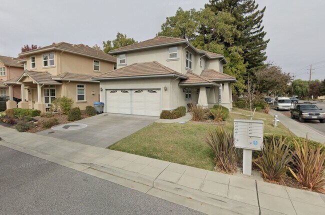
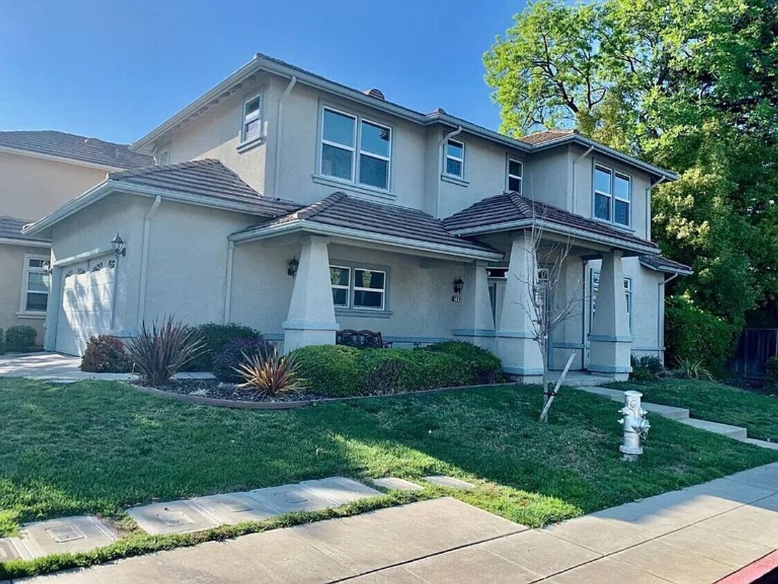
294 Skyview Ct
Mountain View, CA 94043
Today
|
Edit
Favorites
650-349-9300
-
Bedrooms
3
-
Bathrooms
2.5
-
Square Feet
1,670 sq ft
-
Available
Available Now
294 Skyview Ct

Favorites
About This Home
$5,950 deposit,
Available Now
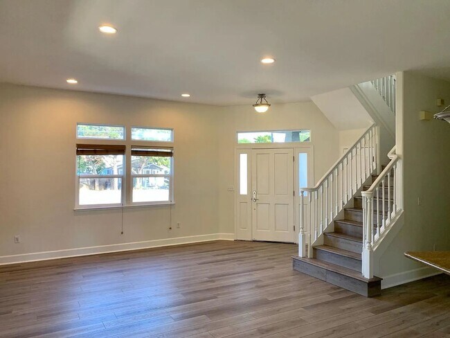
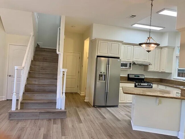
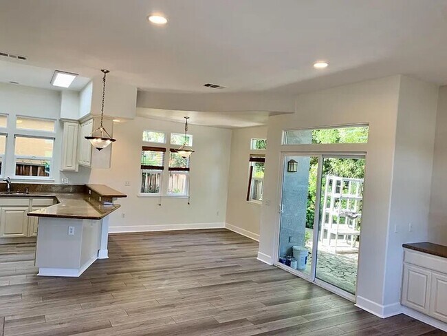
Beautiful 2-level home featuring fresh interior paint and new luxury vinyl plank flooring throughout. The spacious master bedroom suite offers comfort and privacy. Enjoy a cozy gas fireplace in the living room, high ceilings, and double-pane windows that provide plenty of natural light and energy efficiency. The cook’s kitchen is equipped with granite countertops and ample space for entertaining. Additional highlights include a 2-car garage and a backyard with a built-in gas grill — perfect for outdoor gatherings. AVAILABILITY: MARCH 3,2026 PROPERTY FEATURES: - 3 BEDROOMS - 2.5 BATH - 2 Level home - Freshly painted - New luxury vinyl planks - Master bedroom suite - Gas fireplace in living room - Double pane windows - High ceilings - 2 car garage - Cook's kitchen w/ granite counters - Backyard with gas grill Ideally located in the Mountain View Triangle, just a 5-minute walk to the Quad Google Campus and Google Children’s Center. Easy access to Whisman Park, Stevens Creek Trail, and outdoor recreation at Creekside Park, Slater Park, and Chetwood Park. Conveniently close to US 101, 237, and Highway 85 for easy commuting, as well as Caltrain. Located near excellent schools, including Mountain View High School. LEASE TERMS: - RENT: $ 5,950.00 - DEPOSIT: $ 5,950.00 - 1 Year Minimum - Credit / Background Check Required - Gardener APPLICATION FEE: - $50 in Person / Mail - 1107 South B Street in San Mateo - $55 Online/ - Fees apply to a married couple or per adult - Each adult must fill out an application INTERESTED? - Get your pen ready and get more information by calling our office today at VISIT OUR WEBSITE: - For a complete list of our available properties or to apply online, visit DRE#00365928
294 Skyview Ct is a house located in Santa Clara County and the 94043 ZIP Code.
* Price shown is base rent. Excludes user-selected optional fees and variable or usage-based fees and required charges due at or prior to move-in or at move-out. Price, availability, fees, and any applicable rent special are subject to change without notice.
* Square footage definitions vary. Displayed square footage is approximate.
Contact
- Listed by Heritage Realty | Heritage Realty
- Phone Number
- Contact
Location
Get Directions
Known for its fantastic views of the Santa Cruz Mountains, the Wagon Wheel neighborhood of Mountain View, California lies 12 miles southeast of Palo Alto via US-101S. Residents of Wagon Wheel's apartments and home rentals enjoy convenient transportation via light rail, bus, and private shuttle. Featuring an online chat group, this community values resident participation in planning activities such as ice cream socials, community breakfasts, and pumpkin festivals at the local park.
Two parks serve this neighborhood where residents can picnic, relax in an arbor, or join a pick-up baseball game. Whisman Park provides access to the Stevens Creek Trail, with its paved paths for walking, biking, or jogging through scenic natural areas.
Learn more about living in Wagon Wheel
Education
| Colleges & Universities | Distance | ||
|---|---|---|---|
| Colleges & Universities | Distance | ||
| Drive: | 9 min | 3.9 mi | |
| Drive: | 13 min | 5.2 mi | |
| Drive: | 12 min | 7.0 mi | |
| Drive: | 17 min | 7.4 mi |
294 Skyview Ct is within 9 minutes or 3.9 miles from Foothill College, Middlefield. It is also near Foothill Coll., Los Altos and De Anza College.
Transportation options available in Mountain View include Whisman Station, located 0.4 mile from 294 Skyview Ct. 294 Skyview Ct is near Norman Y Mineta San Jose International, located 8.8 miles or 13 minutes away, and San Francisco International, located 25.8 miles or 33 minutes away.
| Transit / Subway | Distance | ||
|---|---|---|---|
| Transit / Subway | Distance | ||
|
|
Walk: | 7 min | 0.4 mi |
|
|
Walk: | 11 min | 0.6 mi |
| Drive: | 2 min | 1.2 mi | |
| Drive: | 2 min | 1.4 mi | |
| Drive: | 4 min | 2.1 mi |
| Commuter Rail | Distance | ||
|---|---|---|---|
| Commuter Rail | Distance | ||
| Drive: | 4 min | 1.7 mi | |
| Drive: | 6 min | 2.8 mi | |
| Drive: | 7 min | 3.7 mi | |
| Drive: | 9 min | 5.5 mi | |
| Drive: | 13 min | 6.2 mi |
| Airports | Distance | ||
|---|---|---|---|
| Airports | Distance | ||
|
Norman Y Mineta San Jose International
|
Drive: | 13 min | 8.8 mi |
|
San Francisco International
|
Drive: | 33 min | 25.8 mi |
Time and distance from 294 Skyview Ct.
| Shopping Centers | Distance | ||
|---|---|---|---|
| Shopping Centers | Distance | ||
| Drive: | 3 min | 1.2 mi | |
| Drive: | 3 min | 1.5 mi | |
| Drive: | 4 min | 2.0 mi |
294 Skyview Ct has 3 shopping centers within 2.0 miles, which is about a 4-minute drive. The miles and minutes will be for the farthest away property.
| Parks and Recreation | Distance | ||
|---|---|---|---|
| Parks and Recreation | Distance | ||
|
Stevens Creek Shoreline Nature Study Area
|
Drive: | 9 min | 3.5 mi |
|
Sunnyvale Baylands Park
|
Drive: | 10 min | 4.7 mi |
|
Redwood Grove
|
Drive: | 11 min | 4.7 mi |
|
J. Pearce Mitchell Park
|
Drive: | 11 min | 5.1 mi |
|
Terman Park
|
Drive: | 11 min | 5.1 mi |
294 Skyview Ct has 5 parks within 5.1 miles, including Stevens Creek Shoreline Nature Study Area, J. Pearce Mitchell Park, and Sunnyvale Baylands Park.
| Hospitals | Distance | ||
|---|---|---|---|
| Hospitals | Distance | ||
| Drive: | 4 min | 2.2 mi | |
| Drive: | 12 min | 7.3 mi | |
| Drive: | 12 min | 7.5 mi |
294 Skyview Ct has 3 hospitals within 7.5 miles, the nearest is El Camino Hospital which is 2.2 miles away and a 4 minute drive.
| Military Bases | Distance | ||
|---|---|---|---|
| Military Bases | Distance | ||
| Drive: | 8 min | 2.8 mi |
294 Skyview Ct is 2.8 miles and a 8 minute drive from Ames Research Center.
You May Also Like
Similar Rentals Nearby


What Are Walk Score®, Transit Score®, and Bike Score® Ratings?
Walk Score® measures the walkability of any address. Transit Score® measures access to public transit. Bike Score® measures the bikeability of any address.
What is a Sound Score Rating?
A Sound Score Rating aggregates noise caused by vehicle traffic, airplane traffic and local sources
294 Skyview Ct
Mountain View, CA 94043