
29 High Ledge Ave
29 High Ledge Ave
Wellesley, MA 02482
2 Weeks Ago
Favorites
29 High Ledge Ave
Favorites
Check Back Soon for Upcoming Availability
| Beds | Baths | Average SF |
|---|---|---|
| 4 Bedrooms 4 Bedrooms 4 Br | 2.5 Baths 2.5 Baths 2.5 Ba | 1,893 SF |
About This Property
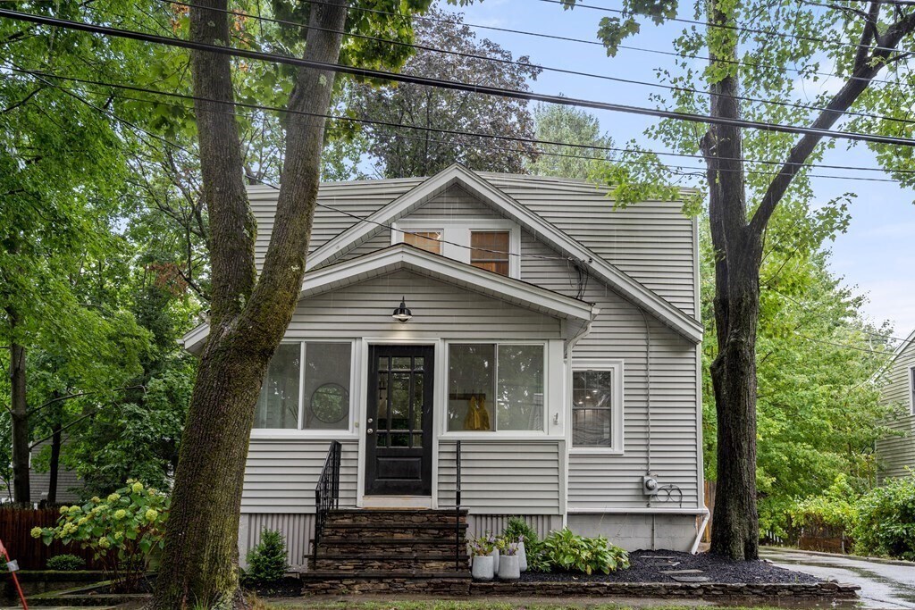
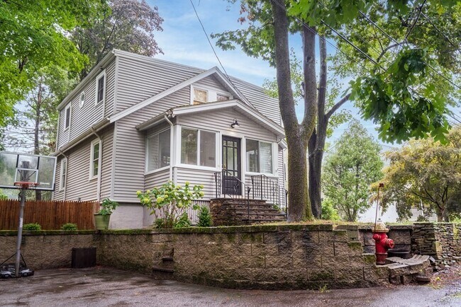
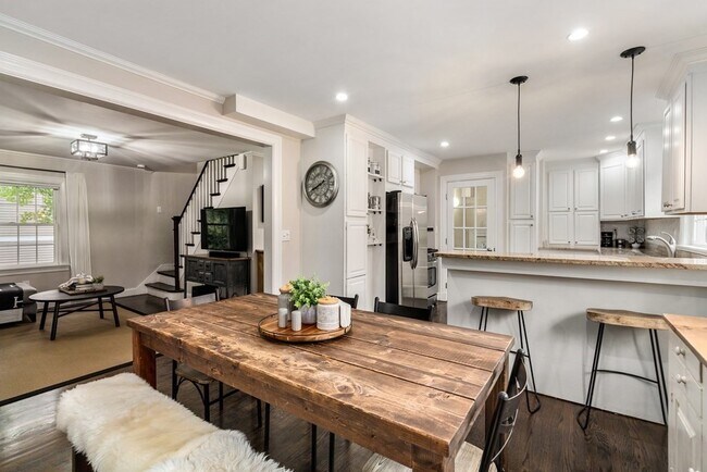
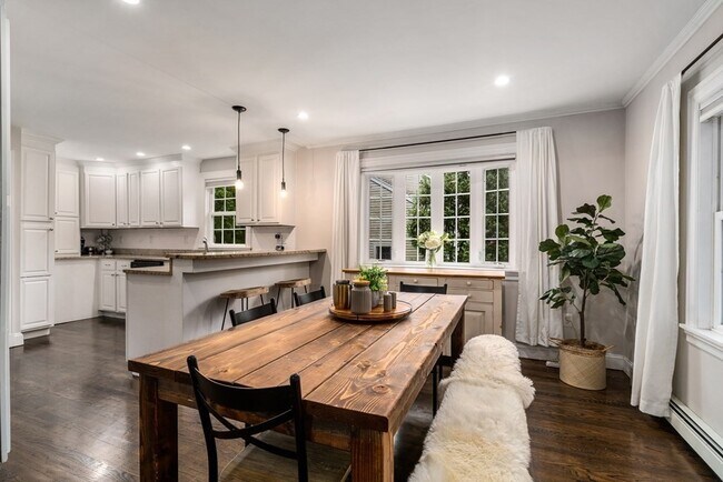
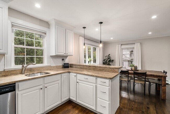
Private cape full of surprises tucked away on a quiet street in Wellesley's Overbrook neighborhood. Open concept kitchen with granite counters and stainless steel appliances opens to a bright dining area. The first floor also features a living room,the fourth bedroom and a full bathroom. The second floor includes two bedrooms with closets,hardwood floors and a Jack and Jill bathroom,as well as a spacious primary bedroom with a walk in closet,and an ensuite tiled bathroom with a good sized walk in shower. There is also a finished bonus area in the basement with a carpeted playroom/office/family room. The large backyard is easily accessed from the first floor and includes both patio and grassy area for play. Extra parking pad on right side of house. Recent updates: refinished floors,upgraded electrical,new patio,paint throughout,5 ductless mini splits for central air,and more! Districted to the blue ribbon award winning Hardy elementary school. A great find! (Matterport avail.)
29 High Ledge Ave is a house located in Norfolk County and the 02482 ZIP Code. This area is served by the Wellesley attendance zone.
Location
Get Directions
Just west of Boston and East of Worcester sits Metro West, a region that houses a group of towns and cities with significant historical backgrounds. A total of 19 municipalities make up the core of this community, but other municipalities are considered to be a part of the Interstate 495/Metro West Corridor.
Learn more about living in Metro WestBelow are rent ranges for similar nearby apartments
| Beds | Average Size | Lowest | Typical | Premium |
|---|---|---|---|---|
| Studio Studio Studio | 617-620 Sq Ft | $1,125 | $2,218 | $3,630 |
| 1 Bed 1 Bed 1 Bed | 875-877 Sq Ft | $1,140 | $2,866 | $9,323 |
| 2 Beds 2 Beds 2 Beds | 1273-1275 Sq Ft | $1,775 | $3,613 | $17,713 |
| 3 Beds 3 Beds 3 Beds | 1569-1573 Sq Ft | $1,000 | $4,772 | $21,131 |
| 4 Beds 4 Beds 4 Beds | 3764 Sq Ft | $1,210 | $6,713 | $30,000 |
Education
| Colleges & Universities | Distance | ||
|---|---|---|---|
| Colleges & Universities | Distance | ||
| Drive: | 8 min | 3.1 mi | |
| Drive: | 9 min | 4.0 mi | |
| Drive: | 11 min | 6.4 mi | |
| Drive: | 16 min | 7.3 mi |
29 High Ledge Ave is within 8 minutes or 3.1 miles from Wellesley College. It is also near Babson College and Framingham State College.
Schools


Public Elementary School
Grades PK-3
320 Students
Nearby
Public Elementary School
Grades K-5
206 Students
Attendance Zone
Public Middle School
Grades 6-8
922 Students
Attendance Zone
Public High School
Grades 9-12
1,412 Students
Attendance Zone
Private Elementary & Middle School
Grades PK-8
185 Students
Nearby
Private Elementary School
Grades 5-6
11 Students
Nearby
Private Middle & High School
Grades 6-12
496 Students
Nearby
School data provided by
 The GreatSchools Rating helps parents compare schools within a state based on a variety of school quality indicators and provides a helpful picture of how effectively each school serves all of its students. Ratings are on a scale of 1 (below average) to 10 (above average) and can include test scores, college readiness, academic progress, advanced courses, equity, discipline and attendance data. We also advise parents to visit schools, consider other information on school performance and programs, and consider family needs as part of the school selection process.
View GreatSchools Rating Methodology
Data provided by GreatSchools.org © 2025. All rights reserved.
View GreatSchools Rating Methodology
Data provided by GreatSchools.org © 2025. All rights reserved.
Transportation options available in Wellesley include Woodland Station, located 5.4 miles from 29 High Ledge Ave. 29 High Ledge Ave is near General Edward Lawrence Logan International, located 19.4 miles or 32 minutes away, and Worcester Regional, located 30.4 miles or 51 minutes away.
| Transit / Subway | Distance | ||
|---|---|---|---|
| Transit / Subway | Distance | ||
|
|
Drive: | 10 min | 5.4 mi |
|
|
Drive: | 11 min | 5.5 mi |
|
|
Drive: | 11 min | 6.1 mi |
|
|
Drive: | 13 min | 6.7 mi |
|
|
Drive: | 13 min | 6.9 mi |
| Commuter Rail | Distance | ||
|---|---|---|---|
| Commuter Rail | Distance | ||
|
|
Drive: | 5 min | 2.4 mi |
|
|
Drive: | 6 min | 3.4 mi |
|
|
Drive: | 6 min | 3.7 mi |
|
|
Drive: | 9 min | 4.2 mi |
|
|
Drive: | 11 min | 5.8 mi |
| Airports | Distance | ||
|---|---|---|---|
| Airports | Distance | ||
|
General Edward Lawrence Logan International
|
Drive: | 32 min | 19.4 mi |
|
Worcester Regional
|
Drive: | 51 min | 30.4 mi |
Time and distance from 29 High Ledge Ave.
| Shopping Centers | Distance | ||
|---|---|---|---|
| Shopping Centers | Distance | ||
| Drive: | 4 min | 1.7 mi | |
| Drive: | 3 min | 1.8 mi | |
| Drive: | 4 min | 2.3 mi |
29 High Ledge Ave has 3 shopping centers within 2.3 miles, which is about a 4-minute drive. The miles and minutes will be for the farthest away property.
| Parks and Recreation | Distance | ||
|---|---|---|---|
| Parks and Recreation | Distance | ||
|
Whitin Observatory
|
Drive: | 6 min | 2.3 mi |
|
Wellesley College Botanic Gardens
|
Drive: | 5 min | 2.6 mi |
|
Hamlen Woods
|
Drive: | 7 min | 3.3 mi |
|
Horticultural Society at Elm Bank
|
Drive: | 12 min | 4.6 mi |
|
Cochituate State Park
|
Drive: | 18 min | 11.5 mi |
29 High Ledge Ave has 5 parks within 11.5 miles, including Wellesley College Botanic Gardens, Whitin Observatory, and Hamlen Woods.
| Hospitals | Distance | ||
|---|---|---|---|
| Hospitals | Distance | ||
| Drive: | 9 min | 5.2 mi | |
| Drive: | 11 min | 5.9 mi | |
| Drive: | 12 min | 6.5 mi |
29 High Ledge Ave has 3 hospitals within 6.5 miles, the nearest is Newton - Wellesley Hospital which is 5.2 miles away and a 9 minute drive.
| Military Bases | Distance | ||
|---|---|---|---|
| Military Bases | Distance | ||
| Drive: | 6 min | 3.3 mi | |
| Drive: | 27 min | 13.5 mi |
29 High Ledge Ave is 3.3 miles from US Military Reservation, and is convenient to other military bases, including Hanscom Air Force Base.
You May Also Like
Similar Rentals Nearby
-
-

-

-
 $5,000Total Monthly Price4 Beds, 2.5 Baths, 2,100 sq ftHouse for Rent
 -
 $8,500Total Monthly Price5 Beds, 4.5 Baths, 3,600 sq ftHouse for Rent
 -
 $5,125Total Monthly Price4 Beds, 2.5 Baths, 1,816 sq ftHouse for Rent
 -
 $11,000Total Monthly Price5 Beds, 4.5 Baths, 4,136 sq ftHouse for Rent
 -
 $9,500Total Monthly Price5 Beds, 3 Baths, 2,800 sq ftHouse for Rent
 -
 $6,500Total Monthly Price5 Beds, 3.5 Baths, 2,498 sq ftHouse for Rent
 -
 $7,200Total Monthly Price6 Beds, 2.5 Baths, 9,999 sq ftHouse for Rent
What Are Walk Score®, Transit Score®, and Bike Score® Ratings?
Walk Score® measures the walkability of any address. Transit Score® measures access to public transit. Bike Score® measures the bikeability of any address.
What is a Sound Score Rating?
A Sound Score Rating aggregates noise caused by vehicle traffic, airplane traffic and local sources

29 High Ledge Ave
Wellesley, MA 02482