

$1,890
/ Month
29 Hall St
Chagrin Falls, OH 44022
2 Weeks Ago
|
Edit
Favorites
29 Hall St

Favorites
Check Back Soon for Upcoming Availability
| Beds | Baths | Average SF |
|---|---|---|
| 4 Bedrooms 4 Bedrooms 4 Br | 1.5 Baths 1.5 Baths 1.5 Ba | 1,554 SF |
Fees and Policies
The fees listed below are community-provided and may exclude utilities or add-ons. All payments are made directly to the property and are non-refundable unless otherwise specified.
- Dogs Allowed
-
Fees not specified
- Cats Allowed
-
Fees not specified
About This Property
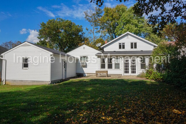
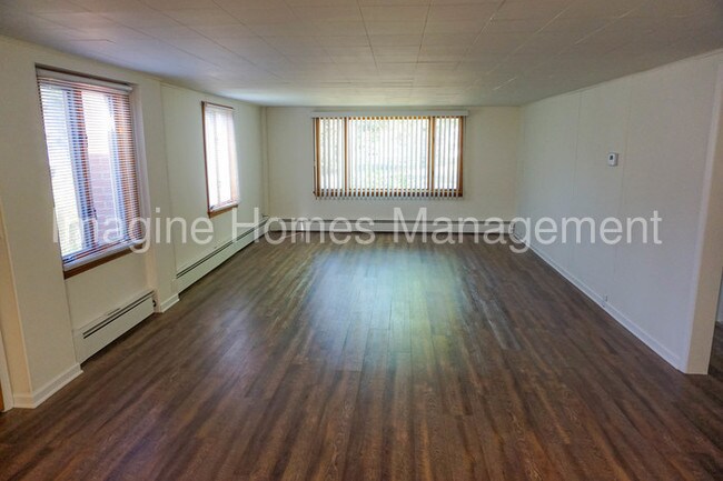
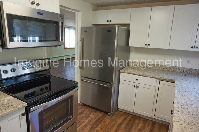
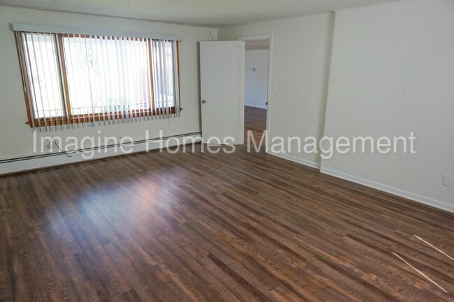
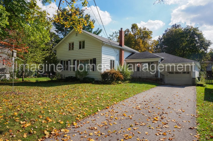
This beautiful updated cape cod is located in the heart of historic Chagrin Falls Village in a family friendly neighborhood, only a short walking distance to local shops, restaurants and community activities. This home includes 2 bedrooms and 1 full bath on the first floor and a second floor that could be two bedrooms or one large suite with a half bath. New stainless steel appliances, granite countertops in the kitchen, and new luxury vinyl flooring throughout. This home offers an excellent bonus sun room, a one car garage and fenced in back yard. Rental Terms: Rent: $1,890, Application Fee: $35, Security Deposit: $1,890, Available Now Pet Policy: Pets will be considered with an additional fee. For more information, and for a list of our available properties, visit www.imagine-homes.com. This property allows self guided viewing without an appointment. Contact for details.
29 Hall St is a house located in Cuyahoga County and the 44022 ZIP Code. This area is served by the Chagrin Falls Exempted Village School District attendance zone.
29 Hall St,
Chagrin Falls,
OH
44022
Southeast Cleveland is a sprawling suburb that encompasses a few cities and neighborhoods. Rentals in the area range from affordable to upscale, so there’s something for every renter. Locals enjoy proximity to Downtown Cleveland, located only 20 miles northwest of town. Southeast Cleveland is home to local restaurants like the Rusty Bucket Restaurant and Tavern, along with chain eateries and abundant shopping options. Country clubs, neighborhood parks, and local college campuses can be found within this region. State Route 43, U.S. Highway 422, and Interstates 480 and 271 making commuting around the Cleveland area simple.
Learn more about living in Southeast Cleveland
Education
| Colleges & Universities | Distance | ||
|---|---|---|---|
| Colleges & Universities | Distance | ||
| Drive: | 15 min | 7.2 mi | |
| Drive: | 16 min | 7.4 mi | |
| Drive: | 15 min | 7.7 mi | |
| Drive: | 22 min | 10.2 mi |
29 Hall St is within 15 minutes or 7.2 miles from Cuyahoga C.C., East. It is also near Ursuline College and Cuyahoga C.C., Eastern Campus.
Schools


Public Elementary School
Grades PK-5
Attendance Zone
Public Elementary School
Grades K-5
Attendance Zone
Public Middle School
Grades 6-8
Attendance Zone
Public High School
Grades 9-12
Attendance Zone
Private Elementary, Middle & High School
Grades K-12
Nearby
Private Elementary & Middle School
Grades PK-8
Nearby
Private Elementary & Middle School
Grades K-8
Nearby
School data provided by
 The GreatSchools Rating helps parents compare schools within a state based on a variety of school quality indicators and provides a helpful picture of how effectively each school serves all of its students. Ratings are on a scale of 1 (below average) to 10 (above average) and can include test scores, college readiness, academic progress, advanced courses, equity, discipline and attendance data. We also advise parents to visit schools, consider other information on school performance and programs, and consider family needs as part of the school selection process.
View GreatSchools Rating Methodology
Data provided by GreatSchools.org © 2026. All rights reserved.
View GreatSchools Rating Methodology
Data provided by GreatSchools.org © 2026. All rights reserved.
Transportation options available in Chagrin Falls include Green, located 8.8 miles from 29 Hall St. 29 Hall St is near Cleveland-Hopkins International, located 25.8 miles or 42 minutes away.
| Transit / Subway | Distance | ||
|---|---|---|---|
| Transit / Subway | Distance | ||
|
|
Drive: | 18 min | 8.8 mi |
|
|
Drive: | 19 min | 8.9 mi |
|
|
Drive: | 18 min | 10.3 mi |
|
|
Drive: | 19 min | 11.1 mi |
|
|
Drive: | 20 min | 11.5 mi |
| Commuter Rail | Distance | ||
|---|---|---|---|
| Commuter Rail | Distance | ||
| Drive: | 28 min | 14.1 mi | |
| Drive: | 28 min | 15.2 mi | |
| Drive: | 34 min | 18.3 mi | |
|
Boston Mill
|
Drive: | 35 min | 21.2 mi |
| Drive: | 35 min | 23.0 mi |
| Airports | Distance | ||
|---|---|---|---|
| Airports | Distance | ||
|
Cleveland-Hopkins International
|
Drive: | 42 min | 25.8 mi |
Walkability Near 29 Hall St Chagrin Falls, OH 44022
Getting Around
 What do Walkability, Transit, Drivability, and Bikeability mean?
Walkability measures the walking distance to day-to-day needs.
Transit measures access to public transportation.
Drivability measures congestion, parking availability, and access to major roads.
Bikeability measures the suitability for cycling.
How It Works
What do Walkability, Transit, Drivability, and Bikeability mean?
Walkability measures the walking distance to day-to-day needs.
Transit measures access to public transportation.
Drivability measures congestion, parking availability, and access to major roads.
Bikeability measures the suitability for cycling.
How It Works
Fairly Walkable
Walkability
50
/ 100
Very Drivable
Drivability
80
/ 100
Moderately Bikeable
Bikeability
60
/ 100
Scores provided by
-
Soundscore™
-
/ 100
Traffic
-Airport
-Businesses
-Scores provided by
HowLoud What is a Sound Score Rating? A Sound Score Rating aggregates noise caused by vehicle traffic, airplane traffic and local sources. How It WorksTime and distance from 29 Hall St.
| Shopping Centers | Distance | ||
|---|---|---|---|
| Shopping Centers | Distance | ||
| Walk: | 8 min | 0.4 mi | |
| Walk: | 10 min | 0.6 mi | |
| Drive: | 5 min | 2.9 mi |
29 Hall St has 3 shopping centers within 2.9 miles, which is about a 5-minute drive. The miles and minutes will be for the farthest away property.
| Parks and Recreation | Distance | ||
|---|---|---|---|
| Parks and Recreation | Distance | ||
|
South Chagrin Reservation
|
Drive: | 5 min | 2.3 mi |
|
Frohring Meadows
|
Drive: | 6 min | 2.6 mi |
|
The West Woods
|
Drive: | 11 min | 6.0 mi |
|
Bessie Benner Metzenbaum Park
|
Drive: | 14 min | 6.8 mi |
|
Beartown Lakes Reservation
|
Drive: | 24 min | 10.2 mi |
29 Hall St has 5 parks within 10.2 miles, including South Chagrin Reservation, Frohring Meadows, and The West Woods.
| Hospitals | Distance | ||
|---|---|---|---|
| Hospitals | Distance | ||
| Drive: | 13 min | 7.3 mi | |
| Drive: | 16 min | 8.6 mi | |
| Drive: | 17 min | 8.7 mi |
29 Hall St has 3 hospitals within 8.7 miles, the nearest is University Hospitals Ahuja Medical Center which is 7.3 miles away and a 13 minute drive.
| Military Bases | Distance | ||
|---|---|---|---|
| Military Bases | Distance | ||
| Drive: | 106 min | 86.0 mi |
29 Hall St is 86.0 miles and a 106 minute drive from Mansfield Lahm Airport Air Guard Station.
You May Also Like
Similar Rentals Nearby


What Are Walk Score®, Transit Score®, and Bike Score® Ratings?
Walk Score® measures the walkability of any address. Transit Score® measures access to public transit. Bike Score® measures the bikeability of any address.
What is a Sound Score Rating?
A Sound Score Rating aggregates noise caused by vehicle traffic, airplane traffic and local sources.
29 Hall St
Chagrin Falls, OH 44022