

$4,195 / Month
2863 California St Unit B
San Francisco, CA 94115
2 Weeks Ago
Favorites
2863 California St Unit B

Favorites
Check Back Soon for Upcoming Availability
| Beds | Baths | Average SF |
|---|---|---|
| 2 Bedrooms 2 Bedrooms 2 Br | 2 Baths 2 Baths 2 Ba | — |
About This Property
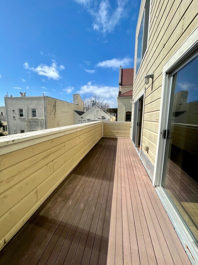
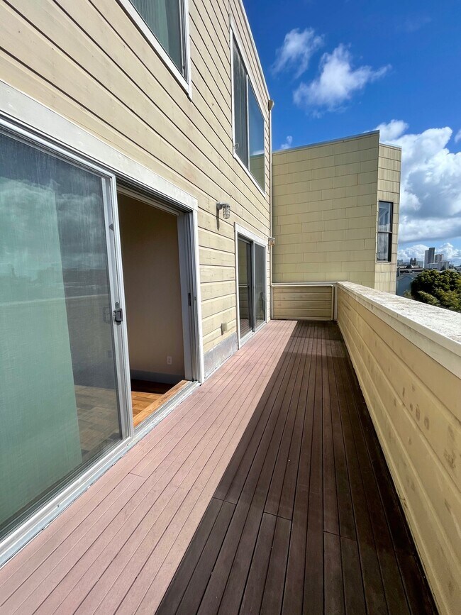
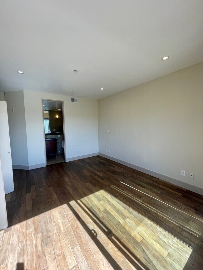
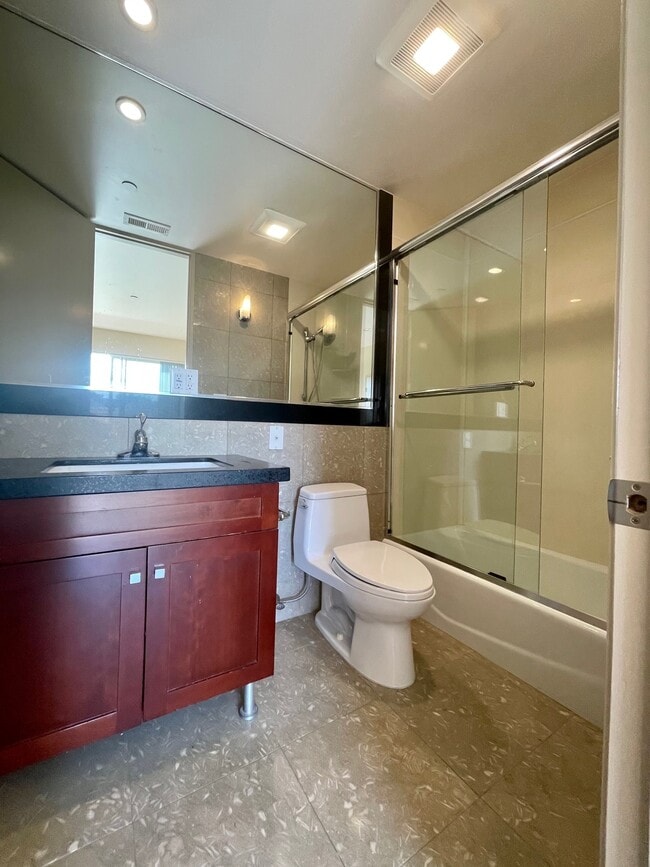
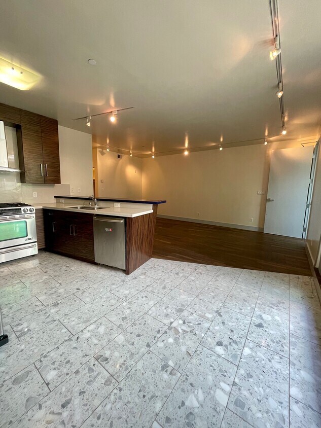
2863 California is a Non- Rent Controlled 2 BR x 2 Bath Condo with a Private Back Deck and a Shared Common Area Patio space. There is also a Shared Roof Deck! 1 Parking Stall included in Rent with Laundry IN Unit. Only Trash included in Rent, Tenants pay for Water and PGE. Prime Pacific Heights at Postcard Perfect near Alta Plaza Park and Divisadero. Sorry NO pets Signature Space Large Living Room / Parlor + 2 BR's of similar size and 2 Full Bathrooms. Updated Baths Where History Meets Modernity. Trophy Location Near Upscale Upper Fillmore Retail. Privacy + Quiet Enjoyment in Prestigious Neighborhood. Walk to Mayflower Market. Mollie Stones Has Shopper Shuttle. Jonathan Adler. Salt &;;; Straw. Alice &;;; Olivia. Palmer's. Rag &;;; Bone. Multiple MUNI Routes Including #22, #10 &;;; #3 Nearby. Please EMAIL for Fastest Reply: Name. Address Request. Apt #. Move Date. Dave Chesnosky Leasing &; Multi Unit Specialist RentingSF DRE # 01886014
2863 California St is a condo located in San Francisco County and the 94115 ZIP Code. This area is served by the San Francisco Unified attendance zone.
Location
Get Directions
Lower Pacific Heights is a vibrant San Francisco neighborhood situated between Pacific Heights, Japantown, the Fillmore District, and Laurel Heights. Formerly known as Upper Fillmore, Lower Pacific Heights offers residents a wide variety of apartments, condos, and houses available for rent, many of which boast scenic views due to the neighborhood’s hilly environment.
Lower Pacific Heights is regarded for its walkable layout, with many rentals situated within easy walking distance of the diverse restaurants, shops, coffeehouses, and bars that line Fillmore Street, the community’s main commercial thoroughfare. The neighborhood’s central locale is a major part of its allure, providing quick access to Union Square, the University of San Francisco, the Financial District, several prominent medical centers, tech employers, landmarks, and more.
Learn more about living in Lower Pacific HeightsBelow are rent ranges for similar nearby apartments
Education
| Colleges & Universities | Distance | ||
|---|---|---|---|
| Colleges & Universities | Distance | ||
| Walk: | 7 min | 0.4 mi | |
| Drive: | 3 min | 1.2 mi | |
| Drive: | 6 min | 2.0 mi | |
| Drive: | 9 min | 3.2 mi |
2863 California St Unit B is within 7 minutes or 0.4 mile from UC San Francisco, Mount Zion. It is also near University of San Francisco and Academy of Art University.
Schools


Public Elementary School
Grades K-5
Nearby
Public Elementary School
Grades K-5
136 Students
Attendance Zone
Public Middle School
Grades 6-8
666 Students
Attendance Zone
Charter High School
Grades 9-12
489 Students
Nearby
Private Elementary, Middle & High School
Grades K-12
404 Students
Nearby
Private High School
Grades 9-12
291 Students
Nearby
School data provided by
 The GreatSchools Rating helps parents compare schools within a state based on a variety of school quality indicators and provides a helpful picture of how effectively each school serves all of its students. Ratings are on a scale of 1 (below average) to 10 (above average) and can include test scores, college readiness, academic progress, advanced courses, equity, discipline and attendance data. We also advise parents to visit schools, consider other information on school performance and programs, and consider family needs as part of the school selection process.
View GreatSchools Rating Methodology
Data provided by GreatSchools.org © 2025. All rights reserved.
View GreatSchools Rating Methodology
Data provided by GreatSchools.org © 2025. All rights reserved.
Transportation options available in San Francisco include Van Ness And California, located 1.1 miles from 2863 California St Unit B. 2863 California St Unit B is near San Francisco International, located 15.3 miles or 25 minutes away, and Metro Oakland International, located 21.2 miles or 35 minutes away.
| Transit / Subway | Distance | ||
|---|---|---|---|
| Transit / Subway | Distance | ||
|
|
Walk: | 21 min | 1.1 mi |
|
|
Drive: | 3 min | 1.3 mi |
|
|
Drive: | 3 min | 1.3 mi |
|
|
Drive: | 5 min | 1.5 mi |
|
|
Drive: | 4 min | 1.5 mi |
| Commuter Rail | Distance | ||
|---|---|---|---|
| Commuter Rail | Distance | ||
| Drive: | 9 min | 4.3 mi | |
| Drive: | 9 min | 4.4 mi | |
| Drive: | 10 min | 5.1 mi | |
| Drive: | 10 min | 5.2 mi | |
| Drive: | 14 min | 7.4 mi |
| Airports | Distance | ||
|---|---|---|---|
| Airports | Distance | ||
|
San Francisco International
|
Drive: | 25 min | 15.3 mi |
|
Metro Oakland International
|
Drive: | 35 min | 21.2 mi |
Time and distance from 2863 California St Unit B.
| Shopping Centers | Distance | ||
|---|---|---|---|
| Shopping Centers | Distance | ||
| Walk: | 15 min | 0.8 mi | |
| Walk: | 17 min | 0.9 mi | |
| Drive: | 4 min | 1.4 mi |
2863 California St Unit B has 3 shopping centers within 1.4 miles, which is about a 4-minute walk. The miles and minutes will be for the farthest away property.
| Parks and Recreation | Distance | ||
|---|---|---|---|
| Parks and Recreation | Distance | ||
|
Exploratorium
|
Drive: | 3 min | 1.6 mi |
|
Buena Vista Park
|
Drive: | 6 min | 1.6 mi |
|
Conservatory of Flowers
|
Drive: | 4 min | 1.8 mi |
|
Randall Museum
|
Drive: | 7 min | 2.2 mi |
|
San Francisco Maritime National Historical Park
|
Drive: | 6 min | 2.5 mi |
2863 California St Unit B has 5 parks within 2.5 miles, including Exploratorium, Buena Vista Park, and Conservatory of Flowers.
| Hospitals | Distance | ||
|---|---|---|---|
| Hospitals | Distance | ||
| Walk: | 9 min | 0.5 mi | |
| Drive: | 4 min | 1.4 mi | |
| Drive: | 4 min | 1.5 mi |
2863 California St Unit B has 3 hospitals within 1.5 miles, the nearest is Kaiser Foundation Hospital - San Francisco which is 0.5 mile away and a 9 minute walk.
| Military Bases | Distance | ||
|---|---|---|---|
| Military Bases | Distance | ||
| Drive: | 10 min | 3.5 mi | |
| Drive: | 11 min | 3.9 mi | |
| Drive: | 17 min | 7.3 mi |
2863 California St Unit B has 3 military bases within 7.3 miles, the nearest is East Fort Miley which is 3.5 miles away and a 10 minute drive.
You May Also Like
Similar Rentals Nearby


What Are Walk Score®, Transit Score®, and Bike Score® Ratings?
Walk Score® measures the walkability of any address. Transit Score® measures access to public transit. Bike Score® measures the bikeability of any address.
What is a Sound Score Rating?
A Sound Score Rating aggregates noise caused by vehicle traffic, airplane traffic and local sources
2863 California St
San Francisco, CA 94115