$1,650
Total Monthly Price
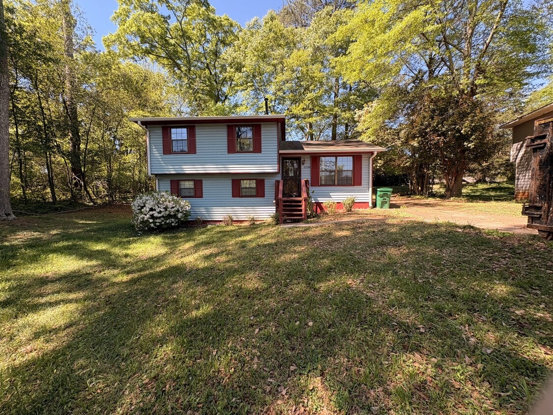
2794 Stardust Ct
Decatur, GA 30034
Favorites
-
Bedrooms
3
-
Bathrooms
2.5
-
Square Feet
1,528 sq ft
-
Available
Available Now
Highlight
- Playground
2794 Stardust Ct

Favorites
About This Home
12 Month Lease,
$1,850 deposit,
Available Now
Welcome to Stardust Court, a spacious single-family home tucked away on a quiet cul-de-sac in Decatur. This 3-bedroom, 2.5-bath home offers approximately 1,528 square feet of living space with a practical layout, comfortable room sizes, and strong potential for renters or buyers. Located in the 30034 area of DeKalb County, this property offers convenient access to nearby schools, shopping, dining, parks, medical care, and major Atlanta-area commuter routes. Buyers or renters will appreciate proximity to Columbia Drive, Flat Shoals Parkway, Candler Road, I-20, I-285, The Gallery at South DeKalb, Exchange Park, and Downtown Decatur. Whatever you are looking for, Stardust Court offers a strong combination of space, location, and long-term upside. Nearby Schools • Columbia Elementary School — listed as a nearby school for the property. • Columbia Middle School — listed as a nearby school for the property. • Columbia High School — listed as a nearby school for the property. • DeKalb County School District — school assignments should be verified directly with the district before publishing final materials. Nearby Shopping • The Gallery at South DeKalb — major nearby retail destination on Candler Road. • Candler Road retail corridor — convenient access to grocery, pharmacies, banks, restaurants, gas, and everyday services. • Flat Shoals Parkway shopping corridor — nearby daily-needs shopping, grocery, service businesses, and casual dining. • South DeKalb / Panthersville area retail — additional shopping and services near I-20 and Candler Road. • Downtown Decatur — broader shopping, dining, entertainment, and local business district within the greater Decatur area. Nearby Dining • Candler Road dining corridor — convenient mix of casual dining, takeout, fast food, and neighborhood restaurants. • Flat Shoals Parkway dining corridor — nearby restaurants, coffee, fast food, and local food options. • The Gallery at South DeKalb area restaurants — dining options near the mall and surrounding shopping centers. • Downtown Decatur restaurants — broader dining district with local restaurants, cafés, breweries, and nightlife. • East Atlanta / Glenwood / Memorial Drive dining areas — additional intown dining options accessible by nearby commuter routes. Nearby Parks & Recreation • Exchange Park — nearby DeKalb County park and recreation area in Decatur. • Exchange Recreation Center / Exchange Park area — community recreation access near Columbia Drive and surrounding neighborhoods. • Chapel Hill Park — neighborhood park option in the Decatur area. • Gresham Park area — larger nearby recreation area serving south DeKalb communities. • Arabia Mountain National Heritage Area — regional outdoor recreation destination with trails, nature areas, and scenic landscapes east/southeast of Decatur. • DeKalb County parks system — additional parks, playgrounds, athletic fields, and recreation centers throughout the surrounding area. Nearby Hospitals & Medical Centers • Grady Health Center — South DeKalb — located at 4007 Flat Shoals Parkway, Decatur, GA 30034, providing local Grady healthcare access in the same ZIP code. • Emory at Flat Shoals — Primary Care — located at 4153-B Flat Shoals Parkway, Suite 200, Decatur, GA 30034, offering Emory primary care access nearby. • Emory Hillandale Hospital — located at 2801 DeKalb Medical Parkway, Stonecrest, GA 30058, providing regional hospital access east of Decatur. • Emory Decatur Hospital — major Decatur-area hospital and regional medical center. • Grady Memorial Hospital — major downtown Atlanta hospital and emergency care destination. • Piedmont Eastside Medical Center — regional medical center in the Snellville area, serving the broader east metro Atlanta region. Nearby Military Bases / Military Facilities • Fort Gillem / Forest Park area — military-related facility area in Forest Park, southwest of Decatur; relevant for south/east metro Atlanta access. • Dobbins Air Reserve Base — active U.S. Air Force Reserve installation in Cobb County, northwest of Atlanta. • Clay National Guard Center — Georgia National Guard facility in Marietta and a major regional military facility. • Atlanta MEPS / regional military processing facilities — military entrance processing and related facilities serving the broader Atlanta region. • Atlanta VA Medical Center / VA regional facilities — veterans’ healthcare access in the broader Decatur/Atlanta area. Nearby Highways & Major Roads • I-20 — major east-west interstate providing access toward Downtown Atlanta, East Atlanta, Lithonia, Conyers, and Augusta. • I-285 — Atlanta’s perimeter highway, providing regional access around the metro area. • Candler Road — major nearby commercial corridor connecting to The Gallery at South DeKalb and I-20. • Flat Shoals Parkway — nearby corridor with shopping, dining, medical offices, and commuter access. • Columbia Drive — local/regional connector serving Decatur, south DeKalb, and surrounding neighborhoods. • Glenwood Road — major east-west route toward Decatur, East Atlanta, and surrounding communities. • Panthersville Road / Clifton Springs Road area — local connectors serving nearby neighborhoods, schools, parks, and commercial areas. Applicants should have: • No evictions or judgments within the past two years • Verifiable household income at least three times the monthly payment amount • Accurate information on the preliminary questionnaire and application Pets: Pets may be allowed with a pet fee and monthly pet rent per pet. Please discuss with us.
2794 Stardust Ct is a house located in DeKalb County and the 30034 ZIP Code. This area is served by the Dekalb County School District attendance zone.
* Price shown is total price based on community-supplied monthly required fees. Excludes user-selected optional fees and variable or usage-based fees and required charges due at or prior to move-in or at move-out. Price, availability, fees, and any applicable rent special are subject to change without notice.
* Square footage definitions vary. Displayed square footage is approximate.
House Features
- Dining Room
- Office
- Playground
- Walking/Biking Trails
Contact
- Contact
Location
Get Directions
Located about nine miles southeast of Downtown Atlanta, Panthersville is a suburban community teeming with apartments and houses for rent along tree-dense roads. Panthersville residents enjoy the community’s forest-like environment, along with quick access to an array of everyday conveniences strewn along Candler Road and Flat Shoals Road, including those found at the Gallery at South DeKalb.
The neighborhood provides plenty of opportunities for outdoor recreation, with access to Exchange Park, Misty Waters Park, and Gresham Park. Panthersville also sits adjacent to Georgia State University-Perimeter College, making it a great choice for many students, faculty, and staff. Direct access to both I-20 and I-285 connects Panthersville to the rest of the Greater Atlanta area within minutes.
Learn more about living in Panthersville
Education
| Colleges & Universities | Distance | ||
|---|---|---|---|
| Colleges & Universities | Distance | ||
| Drive: | 7 min | 2.5 mi | |
| Drive: | 12 min | 6.2 mi | |
| Drive: | 17 min | 7.2 mi | |
| Drive: | 18 min | 8.8 mi |
2794 Stardust Ct is within 7 minutes or 2.5 miles from Georgia Perim. Coll., Decatur. It is also near Agnes Scott College and Georgia Perim., Clarkston.
Schools


Public Elementary School
Grades PK-5
372 Students
Attendance Zone
Public Middle School
Grades 6-8
498 Students
Attendance Zone
Public High School
Grades 9-12
842 Students
Attendance Zone
Private Elementary, Middle & High School
Grades PK-12
120 Students
Nearby
Private Elementary School
Grades PK-5
Nearby
School data provided by
 The GreatSchools Rating helps parents compare schools within a state based on a variety of school quality indicators and provides a helpful picture of how effectively each school serves all of its students. Ratings are on a scale of 1 (below average) to 10 (above average) and can include test scores, college readiness, academic progress, advanced courses, equity, discipline and attendance data. We also advise parents to visit schools, consider other information on school performance and programs, and consider family needs as part of the school selection process.
View GreatSchools Rating Methodology
Data provided by GreatSchools.org © 2026. All rights reserved.
View GreatSchools Rating Methodology
Data provided by GreatSchools.org © 2026. All rights reserved.
Transportation options available in Decatur include Kensington, located 5.1 miles from 2794 Stardust Ct. 2794 Stardust Ct is near Hartsfield - Jackson Atlanta International, located 13.4 miles or 23 minutes away.
| Transit / Subway | Distance | ||
|---|---|---|---|
| Transit / Subway | Distance | ||
|
|
Drive: | 12 min | 5.1 mi |
|
|
Drive: | 12 min | 6.0 mi |
|
|
Drive: | 14 min | 6.1 mi |
|
|
Drive: | 14 min | 7.1 mi |
|
|
Drive: | 14 min | 7.6 mi |
| Commuter Rail | Distance | ||
|---|---|---|---|
| Commuter Rail | Distance | ||
|
|
Drive: | 22 min | 14.4 mi |
| Airports | Distance | ||
|---|---|---|---|
| Airports | Distance | ||
|
Hartsfield - Jackson Atlanta International
|
Drive: | 23 min | 13.4 mi |
Getting Around
 What do Walkability, Transit, Drivability, and Bikeability mean?
Walkability measures the walking distance to day-to-day needs.
Transit measures access to public transportation.
Drivability measures congestion, parking availability, and access to major roads.
Bikeability measures the suitability for cycling.
How It Works
What do Walkability, Transit, Drivability, and Bikeability mean?
Walkability measures the walking distance to day-to-day needs.
Transit measures access to public transportation.
Drivability measures congestion, parking availability, and access to major roads.
Bikeability measures the suitability for cycling.
How It Works
Somewhat Walkable
Walkability
30
/ 100
Limited Public Transit
Transit
30
/ 100
Exceptionally Drivable
Drivability
100
/ 100
Somewhat Bikeable
Bikeability
30
/ 100
Scores provided by
Busy
Soundscore™
62
/ 100
Traffic
BusyAirport
CalmBusinesses
CalmScores provided by
HowLoud What is a Sound Score Rating? A Sound Score Rating aggregates noise caused by vehicle traffic, airplane traffic and local sources. How It WorksTime and distance from 2794 Stardust Ct.
| Shopping Centers | Distance | ||
|---|---|---|---|
| Shopping Centers | Distance | ||
| Drive: | 4 min | 1.5 mi | |
| Drive: | 4 min | 1.5 mi | |
| Drive: | 4 min | 1.5 mi |
2794 Stardust Ct has 3 shopping centers within 1.5 miles, which is about a 4-minute drive. The miles and minutes will be for the farthest away property.
| Parks and Recreation | Distance | ||
|---|---|---|---|
| Parks and Recreation | Distance | ||
|
Ferns of the World Garden
|
Drive: | 5 min | 2.2 mi |
|
Wylde Center and Oakhurst Community Garden
|
Drive: | 12 min | 5.9 mi |
|
Bradley Observatory
|
Drive: | 12 min | 6.5 mi |
|
Glenn Creek Nature Preserve
|
Drive: | 16 min | 6.5 mi |
|
South River Watershed Alliance
|
Drive: | 14 min | 7.2 mi |
2794 Stardust Ct has 5 parks within 7.2 miles, including Ferns of the World Garden, Wylde Center and Oakhurst Community Garden, and Bradley Observatory.
| Hospitals | Distance | ||
|---|---|---|---|
| Hospitals | Distance | ||
| Drive: | 5 min | 2.3 mi | |
| Drive: | 14 min | 7.6 mi | |
| Drive: | 16 min | 8.2 mi |
2794 Stardust Ct has 3 hospitals within 8.2 miles, the nearest is Georgia Regional Hospital Atlanta which is 2.3 miles away and a 5 minute drive.
| Military Bases | Distance | ||
|---|---|---|---|
| Military Bases | Distance | ||
| Drive: | 20 min | 11.2 mi | |
| Drive: | 22 min | 14.8 mi | |
| Drive: | 43 min | 28.0 mi |
2794 Stardust Ct has 3 military bases within 28.0 miles, the nearest is Fort Gillem which is 11.2 miles away and a 20 minute drive.
Amenities
- Dining Room
- Office
- Playground
- Walking/Biking Trails
2794 Stardust Ct Photos

2794 Stardust Ct
Decatur, GA 30034