


$1,895
/ Month
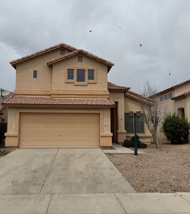
2712 E Denim Trail
Queen Creek, AZ 85143
Today
|
Edit
Favorites
480-876-0169
-
Bedrooms
4
-
Bathrooms
3
-
Square Feet
2,080 sq ft
-
Available
Available Now
2712 E Denim Trail

Favorites
About This Home
$1,500 deposit,
Available Now
Move into this spacious 4-bedroom, 3-bath home at 2712 E Denim Trail and enjoy FREE April rent with immediate move-in! Located in the desirable Rancho Bella Vista community, this two-story home offers over 2,080 sq ft with a flexible layout featuring a downstairs bedroom and full bath—perfect for guests or a home office. The open-concept living area is filled with natural light, complemented by vaulted ceilings and a functional kitchen that flows seamlessly into the main living space. Upstairs, the primary suite includes dual vanities, a soaking tub, and separate shower for added comfort. Additional features include a 2-car garage and low-maintenance yard. Priced at just $1,895/month, this is one of the best values in San Tan Valley—don’t miss out on the limited-time move-in special!
Unique Features
- none
- stove/oven microwave dishwasher garbage disposal
2712 E Denim Trail is a house located in Pinal County and the 85143 ZIP Code.
* Price shown is base rent. Excludes user-selected optional fees and variable or usage-based fees and required charges due at or prior to move-in or at move-out. Price, availability, fees, and any applicable rent special are subject to change without notice.
* Square footage definitions vary. Displayed square footage is approximate.
Contact
- Listed by RoMarCo Properties | RoMarCo Properties
- Phone Number
- Contact
Location
Get Directions
The residents of San Tan Valley, located about an hour's drive southeast of Phoenix, take special pride in their community since they were the ones who chose its name only a few years ago. This newest addition to Phoenix's outlying areas consists of gracious homes for rent, often on large lots and in gated communities. Families in this area appreciate the excellent schools, and many love the fact that they drive past horse farms on their way to recreation in the nearby San Tan Mountains.
During the winter, spring, and fall, you can find your neighbors hiking at San Tan Mountain Regional Park, playing in the splash pad at Founders' Park, or riding horses at the Horseshoe Park & Equestrian Centre. Most people are new to this modern neighborhood, so many residents find it easy to make friendly connections as they relax on their porches viewing the desert sunset.
Learn more about living in San Tan Valley
Amenities
- none
- stove/oven microwave dishwasher garbage disposal
Education
| Colleges & Universities | Distance | ||
|---|---|---|---|
| Colleges & Universities | Distance | ||
| Drive: | 29 min | 15.9 mi | |
| Drive: | 30 min | 16.3 mi | |
| Drive: | 40 min | 21.7 mi | |
| Drive: | 46 min | 27.9 mi |
2712 E Denim Trail is within 29 minutes or 15.9 miles from Arizona State Univ., Polytech. It is also near Chandler-Gilbert C.C., Mesa and Chandler-Gilbert C.C., Pecos.
Getting Around
 What do Walkability, Transit, Drivability, and Bikeability mean?
Walkability measures the walking distance to day-to-day needs.
Transit measures access to public transportation.
Drivability measures congestion, parking availability, and access to major roads.
Bikeability measures the suitability for cycling.
How It Works
What do Walkability, Transit, Drivability, and Bikeability mean?
Walkability measures the walking distance to day-to-day needs.
Transit measures access to public transportation.
Drivability measures congestion, parking availability, and access to major roads.
Bikeability measures the suitability for cycling.
How It Works
Somewhat Walkable
Walkability
20
/ 100
Exceptionally Drivable
Drivability
90
/ 100
Fairly Bikeable
Bikeability
40
/ 100
Scores provided by
-
Soundscore™
-
/ 100
Traffic
-Airport
-Businesses
-Scores provided by
HowLoud What is a Sound Score Rating? A Sound Score Rating aggregates noise caused by vehicle traffic, airplane traffic and local sources. How It WorksYou May Also Like
Similar Rentals Nearby


What Are Walk Score®, Transit Score®, and Bike Score® Ratings?
Walk Score® measures the walkability of any address. Transit Score® measures access to public transit. Bike Score® measures the bikeability of any address.
What is a Sound Score Rating?
A Sound Score Rating aggregates noise caused by vehicle traffic, airplane traffic and local sources.

2712 E Denim Trail
Queen Creek, AZ 85143