$3,600
Total Monthly Price
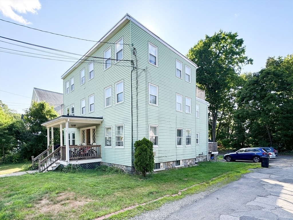
27 Shirley St
Lexington, MA 02421
Today
|
Edit
Favorites
888-610-1610
-
Bedrooms
3
-
Bathrooms
1
-
Square Feet
1,228 sq ft
-
Available
Available Now
Highlights
- Cooling Available
- Property is near schools
- Heating System Uses Natural Gas
27 Shirley St

Favorites
About This Home
$3,700 deposit,
Available Now
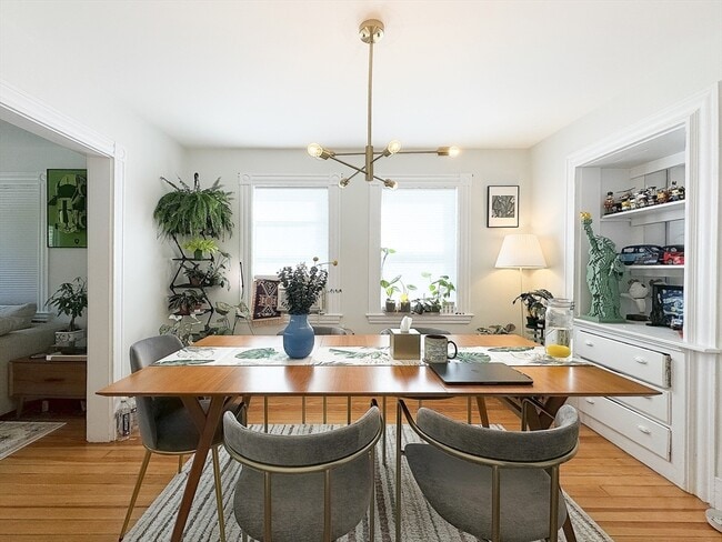
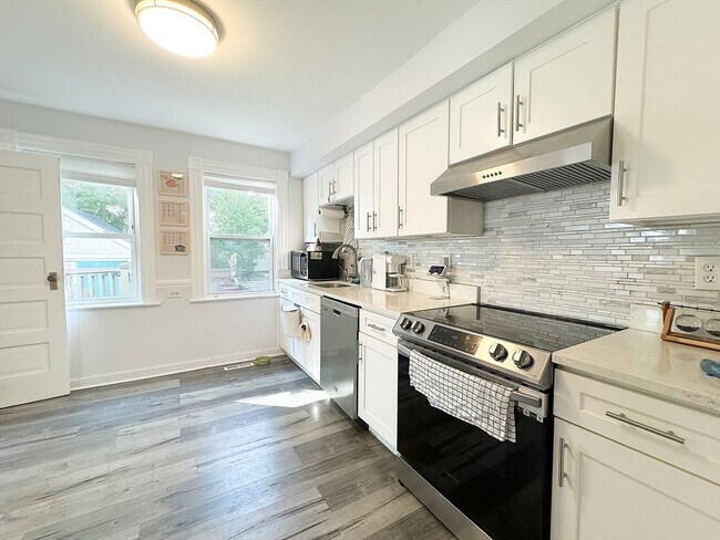
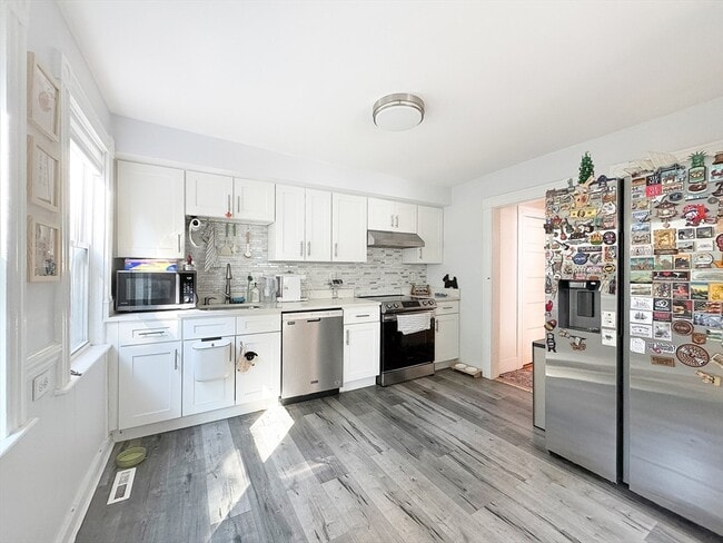
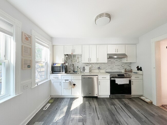
This charming rental unit is a 3-bedroom,1-bathroom apartment located in the heart of Lexington's beautiful A+ school district. With 1228 sqft of living space,the apartment features an open layout that is sun-filled,making it bright and welcoming. It is in great condition and set back from the main street,ensuring a quiet and comfortable living environment. Inside,you'll find a newly renovated kitchen with an electric stove,hardwood floors throughout,window air conditioning units,a private washer/dryer,and a dishwasher. Each bedroom has a closet,and there's an independent basement for additional storage. Outside,enjoy a private and spacious balcony,a large shared lawn,and two parking spaces in the backyard. Conveniently located near supermarkets,pharmacies,schools,and urgent care centers - all just minutes away. It's also a quick 5-minute drive to the I-95 highway. Don't miss out on this fantastic rental opportunity! MLS# 73406965
27 Shirley St is a townhome located in Middlesex County and the 02421 ZIP Code. This area is served by the Lexington attendance zone.
* Price shown is total price based on community-supplied monthly required fees. Excludes user-selected optional fees and variable or usage-based fees and required charges due at or prior to move-in or at move-out. Price, availability, fees, and any applicable rent special are subject to change without notice.
* Square footage definitions vary. Displayed square footage is approximate.
Home Details
Year Built
Built in 1900
Bedrooms and Bathrooms
Primary bedroom located on second floor
1 Full Bathroom
3 Bedrooms
Home Design
Property Attached
Entry on the 1st floor
Interior Spaces
1,228 Sq Ft Home
Kitchen
Range
Dishwasher
Laundry
Laundry in unit
Listing and Financial Details
Security Deposit $3,700
Rent includes water, occupancy only, laundry facilities, parking
Location
Property is near schools
Lot Details
22.96 Acre Lot
Parking
2 Open Parking Spaces
2 Car Parking Spaces
Utilities
Cooling Available
Heating System Uses Natural Gas
Community Details
Overview
Property has a Home Owners Association
Pet Policy
Call for details about the types of pets allowed
Fees and Policies
The fees listed below are community-provided and may exclude utilities or add-ons. All payments are made directly to the property and are non-refundable unless otherwise specified. Use the Cost Calculator to determine costs based on your needs.
-
One-Time Basics
-
Due at Move-In
-
Security Deposit - RefundableCharged per unit.$3,700
-
-
Due at Move-In
Property Fee Disclaimer: Based on community-supplied data and independent market research. Subject to change without notice. May exclude fees for mandatory or optional services and usage-based utilities.
Contact
- Listed by The Elite Team | Phoenix Real Estate Partners,LLC
- Phone Number
-
Source
 MLS Property Information Network
The property listing data and information set forth herein were provided to MLS Property Information Network, Inc. from third party sources, including sellers, lessors and public records, and were compiled by MLS Property Information Network, Inc. The property listing data and information are for the personal, non-commercial use of consumers having a good faith interest in purchasing or leasing listed properties of the type displayed to them and may not be used for any purpose other than to identify prospective properties which such consumers may have a good faith interest in purchasing or leasing. MLS Property Information Network, Inc. and its subscribers disclaim any and all representations and warranties as to the accuracy of the property listing data and information set forth herein. All properties are subject to prior sale, change or withdrawal. Copyright © 2026 MLS Property Information Network, Inc. All rights reserved.
Location
Get Directions
Much of Lexington’s local culture is rooted in the town’s role in the American Revolution, but the community is much more than a historical landmark. Sitting only about 30 minutes outside downtown Boston, folks renting in Lexington are far enough removed from the urban core to enjoy a quiet lifestyle while close enough for an easy commute.
Dozens of public parks dot the community, offering endless opportunities for enjoying nature right in your own neighborhood. The Minuteman Bikeway connects Lexington to Bedford in the north and Arlington and Cambridge in the south. The schools in the area get excellent marks and the crime rate is among the lowest in the nation, so the community is highly desirable for families.
Learn more about living in Lexington
Amenities
- Dishwasher
- Range
- Refrigerator
Education
| Colleges & Universities | Distance | ||
|---|---|---|---|
| Colleges & Universities | Distance | ||
| Drive: | 17 min | 6.1 mi | |
| Drive: | 13 min | 6.5 mi | |
| Drive: | 16 min | 7.6 mi | |
| Drive: | 18 min | 8.1 mi |
27 Shirley St is within 13 minutes or 6.5 miles from Bentley University. It is also near Middlesex C.C., Bedford Campus and Brandeis University.
Schools


Public Elementary School
Grades K-5
538 Students
Attendance Zone
Public Elementary School
Grades PK-3
239 Students
Nearby
Public Middle School
Grades 6-8
907 Students
Attendance Zone
Public High School
Grades 9-12
2,348 Students
Attendance Zone
Private Elementary, Middle & High School
Grades 5-12
Nearby
Private Elementary School
Grades PK-5
98 Students
Nearby
Private Middle & High School
Grades 8-12
29 Students
Nearby
Private Middle & High School
Grades 6-11
Nearby
School data provided by
 The GreatSchools Rating helps parents compare schools within a state based on a variety of school quality indicators and provides a helpful picture of how effectively each school serves all of its students. Ratings are on a scale of 1 (below average) to 10 (above average) and can include test scores, college readiness, academic progress, advanced courses, equity, discipline and attendance data. We also advise parents to visit schools, consider other information on school performance and programs, and consider family needs as part of the school selection process.
View GreatSchools Rating Methodology
Data provided by GreatSchools.org © 2026. All rights reserved.
View GreatSchools Rating Methodology
Data provided by GreatSchools.org © 2026. All rights reserved.
Transportation options available in Lexington include Alewife, located 7.5 miles from 27 Shirley St. 27 Shirley St is near General Edward Lawrence Logan International, located 17.1 miles or 29 minutes away, and Manchester Boston Regional, located 43.0 miles or 57 minutes away.
| Transit / Subway | Distance | ||
|---|---|---|---|
| Transit / Subway | Distance | ||
| Drive: | 12 min | 7.5 mi | |
| Drive: | 16 min | 8.1 mi | |
| Drive: | 18 min | 9.0 mi | |
|
|
Drive: | 16 min | 9.0 mi |
|
|
Drive: | 17 min | 9.1 mi |
| Commuter Rail | Distance | ||
|---|---|---|---|
| Commuter Rail | Distance | ||
|
|
Drive: | 10 min | 5.8 mi |
|
|
Drive: | 11 min | 5.8 mi |
|
|
Drive: | 12 min | 6.9 mi |
|
|
Drive: | 11 min | 7.1 mi |
| Drive: | 18 min | 9.4 mi |
| Airports | Distance | ||
|---|---|---|---|
| Airports | Distance | ||
|
General Edward Lawrence Logan International
|
Drive: | 29 min | 17.1 mi |
|
Manchester Boston Regional
|
Drive: | 57 min | 43.0 mi |
Time and distance from 27 Shirley St.
| Shopping Centers | Distance | ||
|---|---|---|---|
| Shopping Centers | Distance | ||
| Drive: | 3 min | 1.7 mi | |
| Drive: | 6 min | 2.5 mi | |
| Drive: | 7 min | 3.2 mi |
27 Shirley St has 3 shopping centers within 3.2 miles, which is about a 7-minute drive. The miles and minutes will be for the farthest away property.
| Parks and Recreation | Distance | ||
|---|---|---|---|
| Parks and Recreation | Distance | ||
|
Minute Man National Historical Park
|
Drive: | 8 min | 4.3 mi |
|
Beaver Brook Reservation
|
Drive: | 11 min | 5.8 mi |
|
Mass Audubon's Habitat Education Center and Wildlife Sanctuary
|
Drive: | 12 min | 5.8 mi |
|
Walden Pond State Reservation
|
Drive: | 12 min | 6.6 mi |
|
Codman Community Farms
|
Drive: | 14 min | 7.1 mi |
27 Shirley St has 5 parks within 7.1 miles, including Minute Man National Historical Park, Mass Audubon's Habitat Education Center and Wildlife Sanctuary, and Beaver Brook Reservation.
| Hospitals | Distance | ||
|---|---|---|---|
| Hospitals | Distance | ||
| Drive: | 8 min | 3.9 mi | |
| Drive: | 9 min | 5.2 mi | |
| Drive: | 13 min | 6.7 mi |
27 Shirley St has 3 hospitals within 6.7 miles, the nearest is Lahey Hospital & Medical Center, Burlington which is 3.9 miles away and a 8 minute drive.
| Military Bases | Distance | ||
|---|---|---|---|
| Military Bases | Distance | ||
| Drive: | 7 min | 3.5 mi |
27 Shirley St is 3.5 miles and a 7 minute drive from Hanscom Air Force Base.
You May Also Like
Similar Rentals Nearby
-
-
Plus Fees3 Beds$5,595
-
-

-

-

-

-

-

-


What Are Walk Score®, Transit Score®, and Bike Score® Ratings?
Walk Score® measures the walkability of any address. Transit Score® measures access to public transit. Bike Score® measures the bikeability of any address.
What is a Sound Score Rating?
A Sound Score Rating aggregates noise caused by vehicle traffic, airplane traffic and local sources

27 Shirley St
Lexington, MA 02421