
Hedges at Hawthorne
204 Wagaraw Rd,
Hawthorne, NJ 07506
$3,475 - $3,995
Studio - 2 Beds


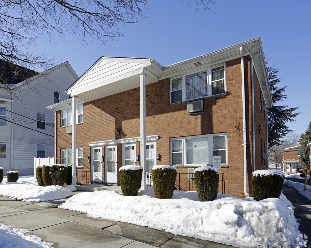
268 McBride Ave in Paterson, NJ is ready for you to move in. The location in Paterson's 07501 area has so much to offer its residents. Come by to view the available floorplans. The professional leasing staff is ready to help you find your perfect fit. Stop by 268 McBride Ave today.
268 McBride Ave is an apartment community located in Passaic County and the 07501 ZIP Code. This area is served by the Paterson Public School District attendance zone.
Air Conditioning
Refrigerator
Tub/Shower
Heating
Paterson sits along the Passaic River just 15 miles from Midtown Manhattan, carrying the weight of genuine American industrial history in nearly every block. As the county seat of Passaic County and New Jersey's third-most populous city, it packs a remarkable amount of character into roughly nine square miles. The Great Falls of the Passaic River, now a National Historical Park, served as the original power source that made Paterson one of the country's first planned industrial cities, earning it the nickname Silk City for its once-dominant role in silk production. William Paterson University adds an academic presence to the broader area, drawing students and staff who contribute to the city's steady, grounded energy.
Neighborhoods here each carry their own personality. Downtown Paterson blends Beaux-Arts architecture with the Center City commercial district, while the Eastside Park Historic District offers tree-lined streets surrounding a 66-acre park.
Learn more about living in PatersonCompare neighborhood and city base rent averages by bedroom.
| Old Great Falls Historic District | Paterson, NJ | |
|---|---|---|
| Studio | - | $1,176 |
| 1 Bedroom | $1,390 | $1,465 |
| 2 Bedrooms | - | $1,945 |
| 3 Bedrooms | - | $2,183 |
| Colleges & Universities | Distance | ||
|---|---|---|---|
| Colleges & Universities | Distance | ||
| Drive: | 4 min | 1.3 mi | |
| Drive: | 3 min | 1.4 mi | |
| Drive: | 9 min | 3.8 mi | |
| Drive: | 9 min | 4.9 mi |


Transportation options available in Paterson include Grove Street, located 10.7 miles from 268 McBride Ave. 268 McBride Ave is near Newark Liberty International, located 21.3 miles or 26 minutes away, and LaGuardia, located 26.0 miles or 38 minutes away.
| Transit / Subway | Distance | ||
|---|---|---|---|
| Transit / Subway | Distance | ||
|
|
Drive: | 16 min | 10.7 mi |
|
|
Drive: | 17 min | 11.0 mi |
|
|
Drive: | 17 min | 11.2 mi |
|
|
Drive: | 18 min | 11.5 mi |
| Commuter Rail | Distance | ||
|---|---|---|---|
| Commuter Rail | Distance | ||
|
|
Drive: | 3 min | 1.3 mi |
|
|
Drive: | 7 min | 3.5 mi |
|
|
Drive: | 7 min | 3.7 mi |
|
|
Drive: | 8 min | 4.6 mi |
|
|
Drive: | 8 min | 4.9 mi |
| Airports | Distance | ||
|---|---|---|---|
| Airports | Distance | ||
|
Newark Liberty International
|
Drive: | 26 min | 21.3 mi |
|
LaGuardia
|
Drive: | 38 min | 26.0 mi |
Scores provided by
Traffic
BusyAirport
CalmBusinesses
ActiveScores provided by
HowLoud What is a Sound Score Rating? A Sound Score Rating aggregates noise caused by vehicle traffic, airplane traffic and local sources. How It WorksTime and distance from 268 McBride Ave.
| Shopping Centers | Distance | ||
|---|---|---|---|
| Shopping Centers | Distance | ||
| Drive: | 3 min | 1.4 mi | |
| Drive: | 4 min | 1.4 mi |
| Parks and Recreation | Distance | ||
|---|---|---|---|
| Parks and Recreation | Distance | ||
|
Rifle Camp Park Observatory
|
Drive: | 7 min | 4.0 mi |
|
Presby Memorial Iris Gardens
|
Drive: | 10 min | 5.9 mi |
|
NJ Audubon Lorrimer Sanctuary
|
Drive: | 12 min | 6.5 mi |
|
Van Vleck House & Gardens
|
Drive: | 14 min | 7.9 mi |
|
Saddle River County Park
|
Drive: | 20 min | 9.5 mi |
| Hospitals | Distance | ||
|---|---|---|---|
| Hospitals | Distance | ||
| Drive: | 3 min | 2.2 mi | |
| Drive: | 11 min | 5.7 mi | |
| Drive: | 10 min | 6.2 mi |
| Military Bases | Distance | ||
|---|---|---|---|
| Military Bases | Distance | ||
| Drive: | 35 min | 23.6 mi | |
| Drive: | 34 min | 25.8 mi | |
| Drive: | 50 min | 35.3 mi |
What Are Walk Score®, Transit Score®, and Bike Score® Ratings?
Walk Score® measures the walkability of any address. Transit Score® measures access to public transit. Bike Score® measures the bikeability of any address.
What is a Sound Score Rating?
A Sound Score Rating aggregates noise caused by vehicle traffic, airplane traffic and local sources.
268 McBride Ave
Paterson, NJ 07501


