
Province
398 W Valley Blvd,
San Gabriel, CA 91776
$2,800 - $6,565
Studio - 3 Beds
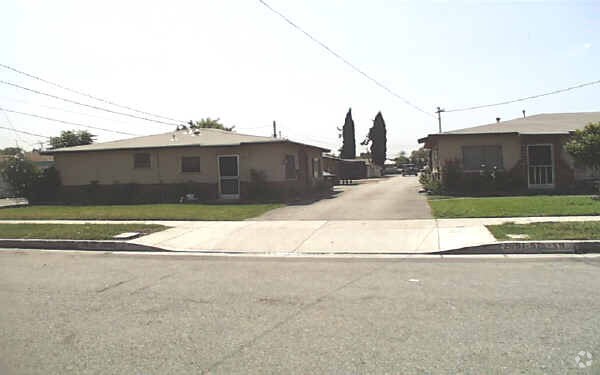

At 2653 --2661 1/2 Muscatel Ave in Rosemead, experience fine living. This community can be found in Rosemead on --2661 1/2 Muscatel Ave. The leasing staff is ready and waiting for you to come by for a tour. Make a visit to check out the apartment floorplan options. You're sure to live the good life at 2653 --2661 1/2 Muscatel Ave. Contact or drop by to check the availability and schedule a tour today.
2653 --2661 1/2 Muscatel Ave is an apartment community located in Los Angeles County and the 91770 ZIP Code. This area is served by the Garvey Elementary attendance zone.
Garvey is a predominantly residential neighborhood located in the heart of San Gabriel Valley. Complemented by cacti and palm trees, a variety of moderately-priced to upscale Mediterranean-style houses, and apartments dot the neighborhood. Garvey has several schools, parks, stores, authentic restaurants, and international grocery stores. Residents enjoy access to several roadways including Interstate 710, Interstate 10, and Highway 60. Downtown Los Angeles, which is just 10 miles away, and other major destinations are convenient to Garvey. If you’re looking for a family-oriented neighborhood or a quiet place convenient for commuting, Garvey is a great choice.
Learn more about living in Garvey| Colleges & Universities | Distance | ||
|---|---|---|---|
| Colleges & Universities | Distance | ||
| Drive: | 11 min | 6.0 mi | |
| Drive: | 10 min | 6.4 mi | |
| Drive: | 12 min | 6.8 mi | |
| Drive: | 17 min | 7.7 mi |


Transportation options available in Rosemead include Atlantic, located 6.4 miles from 2653 --2661 1/2 Muscatel Ave. 2653 --2661 1/2 Muscatel Ave is near Long Beach (Daugherty Field), located 22.9 miles or 36 minutes away, and Bob Hope, located 25.5 miles or 34 minutes away.
| Transit / Subway | Distance | ||
|---|---|---|---|
| Transit / Subway | Distance | ||
|
|
Drive: | 10 min | 6.4 mi |
|
|
Drive: | 11 min | 6.7 mi |
| Drive: | 12 min | 7.3 mi | |
|
|
Drive: | 15 min | 8.0 mi |
|
|
Drive: | 16 min | 8.4 mi |
| Commuter Rail | Distance | ||
|---|---|---|---|
| Commuter Rail | Distance | ||
|
|
Drive: | 8 min | 4.5 mi |
|
|
Drive: | 13 min | 6.2 mi |
|
|
Drive: | 18 min | 8.8 mi |
|
|
Drive: | 14 min | 9.4 mi |
| Drive: | 18 min | 14.8 mi |
| Airports | Distance | ||
|---|---|---|---|
| Airports | Distance | ||
|
Long Beach (Daugherty Field)
|
Drive: | 36 min | 22.9 mi |
|
Bob Hope
|
Drive: | 34 min | 25.5 mi |
Time and distance from 2653 --2661 1/2 Muscatel Ave.
| Shopping Centers | Distance | ||
|---|---|---|---|
| Shopping Centers | Distance | ||
| Walk: | 10 min | 0.6 mi | |
| Walk: | 15 min | 0.8 mi | |
| Walk: | 15 min | 0.8 mi |
| Parks and Recreation | Distance | ||
|---|---|---|---|
| Parks and Recreation | Distance | ||
|
Whittier Narrows Recreation Area
|
Drive: | 7 min | 2.4 mi |
|
Whittier Narrows Nature Center
|
Drive: | 9 min | 4.9 mi |
|
Pio Pico State Historic Park
|
Drive: | 13 min | 5.9 mi |
|
Huntington Botanical Gardens
|
Drive: | 17 min | 6.6 mi |
|
Los Angeles County Arboretum
|
Drive: | 16 min | 7.7 mi |
| Hospitals | Distance | ||
|---|---|---|---|
| Hospitals | Distance | ||
| Drive: | 6 min | 2.8 mi | |
| Drive: | 7 min | 3.1 mi | |
| Drive: | 7 min | 4.2 mi |
| Military Bases | Distance | ||
|---|---|---|---|
| Military Bases | Distance | ||
| Drive: | 37 min | 24.9 mi | |
| Drive: | 37 min | 27.4 mi |
What Are Walk Score®, Transit Score®, and Bike Score® Ratings?
Walk Score® measures the walkability of any address. Transit Score® measures access to public transit. Bike Score® measures the bikeability of any address.
What is a Sound Score Rating?
A Sound Score Rating aggregates noise caused by vehicle traffic, airplane traffic and local sources
2653 --2661 1/2 Muscatel Ave
Rosemead, CA 91770


 - Violet on Virgil")


 - AVA Burbank")