


$1,499
/ Month
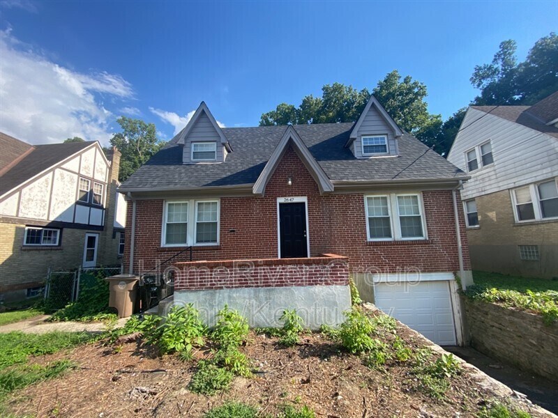
2647 Pancoast Ave
Cincinnati, OH 45211
2 Weeks Ago
Favorites
2647 Pancoast Ave

Favorites
Check Back Soon for Upcoming Availability
| Beds | Baths | Average SF |
|---|---|---|
| 3 Bedrooms 3 Bedrooms 3 Br | 2 Baths 2 Baths 2 Ba | 1,701 SF |
About This Property
Available Now! SECURE NOW! Half off of 1st full month when signed lease on/before 11/15 Contact us for more information or apply by visiting our website. For showing information, please call . This charming home has 3 carpeted bedrooms, a spacious kitchen with stainless steel fridge and range, granite countertops, and crisp white cabinets! New wood plank and carpet flooring throughout! You will enjoy the front-covered porch and walkup! Great backyard space with a patio ready for entertaining. Pets Accepted! To review our Application Qualifying Criteria and Pet Guidelines prior to applying, click the link below: .
2647 Pancoast Ave is a house located in Hamilton County and the 45211 ZIP Code. This area is served by the Cincinnati Public Schools attendance zone.
Location
Get Directions
Situated about five miles northwest of Downtown Cincinnati, Westwood is the largest neighborhood in the city. Residents flock to Westwood for its many affordable historic homes and modern apartments available for rent in addition to its close proximity to I-74, I-75, and all that Downtown Cincinnati has to offer.
While Westwood is a predominantly residential neighborhood, it is also home to a slew of convenient stores and restaurants. Shopping opportunities abound in Westwood, with plenty of national retailers in Western Hills Plaza and local shops in the growing Town Hall District. Numerous neighborhood parks provide ample space to enjoy the outdoors in town as well as the sprawling 1,400-acre Mount Airy Forest, which is partially located in Westwood.
Learn more about living in WestwoodBelow are rent ranges for similar nearby apartments
| Beds | Average Size | Lowest | Typical | Premium |
|---|---|---|---|---|
| Studio Studio Studio | 504-507 Sq Ft | $695 | $778 | $1,280 |
| 1 Bed 1 Bed 1 Bed | 708-714 Sq Ft | $600 | $871 | $1,697 |
| 2 Beds 2 Beds 2 Beds | 884-885 Sq Ft | $780 | $1,232 | $2,253 |
| 3 Beds 3 Beds 3 Beds | 1269-1272 Sq Ft | $1,250 | $1,542 | $1,875 |
| 4 Beds 4 Beds 4 Beds | 1353 Sq Ft | $1,470 | $1,678 | $2,000 |
Education
| Colleges & Universities | Distance | ||
|---|---|---|---|
| Colleges & Universities | Distance | ||
| Drive: | 14 min | 4.8 mi | |
| Drive: | 12 min | 5.1 mi | |
| Drive: | 14 min | 5.6 mi | |
| Drive: | 14 min | 5.8 mi |
2647 Pancoast Ave is within 14 minutes or 4.8 miles from Cincinnati State. It is also near University of Cincinnati and Univ. of Cincinnati, Medical.
Schools


Public Elementary School
Grades PK-6
740 Students
Attendance Zone
Public Middle & High School
Grades 7-12
897 Students
Attendance Zone
Public Middle & High School
Grades 6-12
1,418 Students
Attendance Zone
Private Elementary & Middle School
Grades PK-8
381 Students
Nearby
Private Elementary & Middle School
Grades K-8
164 Students
Nearby
Private High School
Grades 9-12
495 Students
Nearby
School data provided by
 The GreatSchools Rating helps parents compare schools within a state based on a variety of school quality indicators and provides a helpful picture of how effectively each school serves all of its students. Ratings are on a scale of 1 (below average) to 10 (above average) and can include test scores, college readiness, academic progress, advanced courses, equity, discipline and attendance data. We also advise parents to visit schools, consider other information on school performance and programs, and consider family needs as part of the school selection process.
View GreatSchools Rating Methodology
Data provided by GreatSchools.org © 2025. All rights reserved.
View GreatSchools Rating Methodology
Data provided by GreatSchools.org © 2025. All rights reserved.
Transportation options available in Cincinnati include Brewery District Station, Elm & Henry, located 4.6 miles from 2647 Pancoast Ave. 2647 Pancoast Ave is near Cincinnati/Northern Kentucky International, located 18.9 miles or 35 minutes away.
| Transit / Subway | Distance | ||
|---|---|---|---|
| Transit / Subway | Distance | ||
| Drive: | 11 min | 4.6 mi | |
| Drive: | 11 min | 4.8 mi | |
| Drive: | 11 min | 4.9 mi | |
| Drive: | 11 min | 5.0 mi | |
| Drive: | 12 min | 5.1 mi |
| Commuter Rail | Distance | ||
|---|---|---|---|
| Commuter Rail | Distance | ||
|
|
Drive: | 11 min | 4.9 mi |
| Airports | Distance | ||
|---|---|---|---|
| Airports | Distance | ||
|
Cincinnati/Northern Kentucky International
|
Drive: | 35 min | 18.9 mi |
Time and distance from 2647 Pancoast Ave.
| Shopping Centers | Distance | ||
|---|---|---|---|
| Shopping Centers | Distance | ||
| Drive: | 5 min | 1.7 mi | |
| Drive: | 5 min | 1.8 mi | |
| Drive: | 6 min | 2.3 mi |
2647 Pancoast Ave has 3 shopping centers within 2.3 miles, which is about a 6-minute drive. The miles and minutes will be for the farthest away property.
| Parks and Recreation | Distance | ||
|---|---|---|---|
| Parks and Recreation | Distance | ||
|
Imago Earth Center
|
Drive: | 11 min | 3.7 mi |
|
Mt. Airy Forest
|
Drive: | 9 min | 4.1 mi |
|
Wilson Commons
|
Drive: | 12 min | 4.8 mi |
|
Cincinnati History Museum
|
Drive: | 11 min | 4.9 mi |
|
Embshoff Woods
|
Drive: | 15 min | 5.1 mi |
2647 Pancoast Ave has 5 parks within 5.1 miles, including Imago Earth Center, Mt. Airy Forest, and Wilson Commons.
| Hospitals | Distance | ||
|---|---|---|---|
| Hospitals | Distance | ||
| Drive: | 10 min | 3.9 mi | |
| Drive: | 11 min | 4.4 mi | |
| Drive: | 14 min | 5.6 mi |
2647 Pancoast Ave has 3 hospitals within 5.6 miles, the nearest is Mercy Health - West Hospital which is 3.9 miles away and a 10 minute drive.
| Military Bases | Distance | ||
|---|---|---|---|
| Military Bases | Distance | ||
| Drive: | 75 min | 55.7 mi | |
| Drive: | 81 min | 60.8 mi | |
| Drive: | 83 min | 64.1 mi |
2647 Pancoast Ave has 3 military bases within 64.1 miles, the nearest is Gentile Air Force Station which is 55.7 miles away and a 75 minute drive.
You May Also Like
Similar Rentals Nearby


What Are Walk Score®, Transit Score®, and Bike Score® Ratings?
Walk Score® measures the walkability of any address. Transit Score® measures access to public transit. Bike Score® measures the bikeability of any address.
What is a Sound Score Rating?
A Sound Score Rating aggregates noise caused by vehicle traffic, airplane traffic and local sources
2647 Pancoast Ave
Cincinnati, OH 45211