
$1,400 / Month
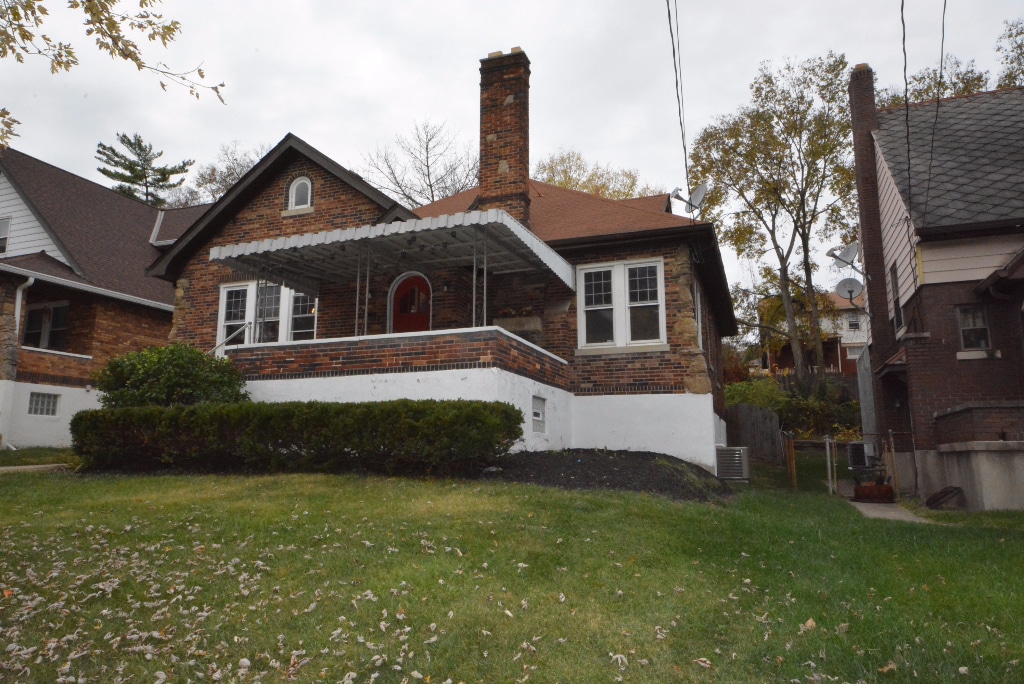
2642 Pancoast Ave
Cincinnati, OH 45211
2 Weeks Ago
Favorites
2642 Pancoast Ave

Favorites
Check Back Soon for Upcoming Availability
| Beds | Baths | Average SF |
|---|---|---|
| 4 Bedrooms 4 Bedrooms 4 Br | 1 Bath 1 Bath 1 Ba | 1,888 SF |
Fees and Policies
The fees below are based on community-supplied data and may exclude additional fees and utilities.
- Parking
-
Other--
About This Property
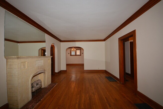
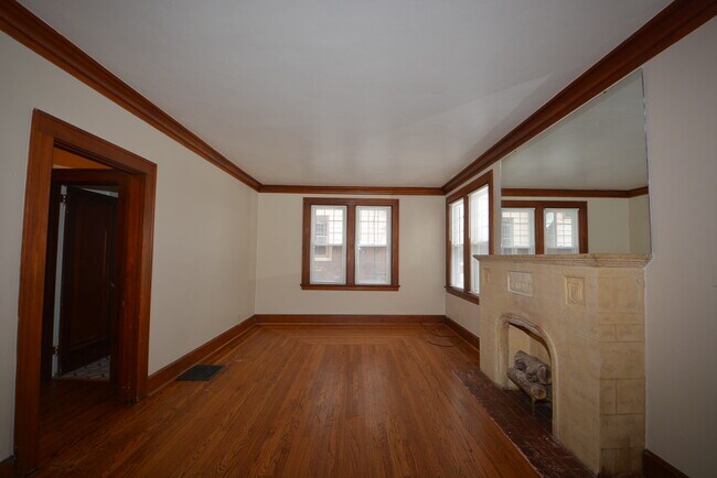
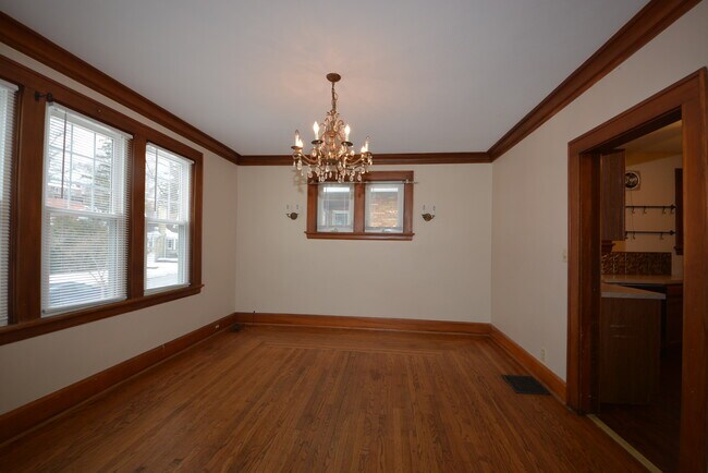
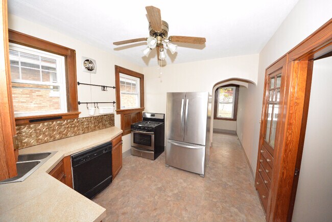
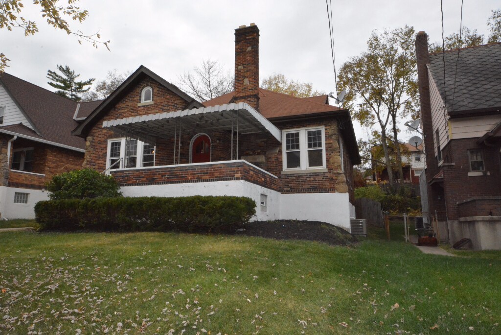
Light and Bright home features Fresh paint, HW floors, kitchen w/ SS appliances, decorative fireplace in living room. Dining Room with Hardwood Floors. Spacious 4 bedroom, 1 full bath. Full basement with lots of storage, yard for outside entertaining and more!! Nice covered front porch. Conveniently located close to shopping, schools entertainment and parks with access to I-74 and I-75. No Pets.
2642 Pancoast Ave is a house located in Hamilton County and the 45211 ZIP Code.
House Features
Air Conditioning
Washer/Dryer Hookup
Hardwood Floors
Fireplace
- Washer/Dryer Hookup
- Air Conditioning
- Smoke Free
- Fireplace
- Stainless Steel Appliances
- Kitchen
- Hardwood Floors
- Dining Room
- Basement
- Porch
- Yard
Location
Get Directions
Situated about five miles northwest of Downtown Cincinnati, Westwood is the largest neighborhood in the city. Residents flock to Westwood for its many affordable historic homes and modern apartments available for rent in addition to its close proximity to I-74, I-75, and all that Downtown Cincinnati has to offer.
While Westwood is a predominantly residential neighborhood, it is also home to a slew of convenient stores and restaurants. Shopping opportunities abound in Westwood, with plenty of national retailers in Western Hills Plaza and local shops in the growing Town Hall District. Numerous neighborhood parks provide ample space to enjoy the outdoors in town as well as the sprawling 1,400-acre Mount Airy Forest, which is partially located in Westwood.
Learn more about living in WestwoodBelow are rent ranges for similar nearby apartments
| Beds | Average Size | Lowest | Typical | Premium |
|---|---|---|---|---|
| Studio Studio Studio | 440 Sq Ft | $725 | $764 | $875 |
| 1 Bed 1 Bed 1 Bed | 658-802 Sq Ft | $600 | $843 | $1,300 |
| 2 Beds 2 Beds 2 Beds | 883-884 Sq Ft | $775 | $1,172 | $1,695 |
| 3 Beds 3 Beds 3 Beds | 1311-1319 Sq Ft | $1,250 | $1,622 | $2,000 |
| 4 Beds 4 Beds 4 Beds | 1500 Sq Ft | $1,550 | $1,716 | $2,020 |
Amenities
- Washer/Dryer Hookup
- Air Conditioning
- Smoke Free
- Fireplace
- Stainless Steel Appliances
- Kitchen
- Hardwood Floors
- Dining Room
- Basement
- Porch
- Yard
Education
| Colleges & Universities | Distance | ||
|---|---|---|---|
| Colleges & Universities | Distance | ||
| Drive: | 14 min | 4.7 mi | |
| Drive: | 12 min | 5.0 mi | |
| Drive: | 14 min | 5.4 mi | |
| Drive: | 14 min | 5.9 mi |
2642 Pancoast Ave is within 14 minutes or 4.7 miles from Cincinnati State. It is also near University of Cincinnati and Univ. of Cincinnati, Medical.
Transportation options available in Cincinnati include Brewery District Station, Elm & Henry, located 4.5 miles from 2642 Pancoast Ave. 2642 Pancoast Ave is near Cincinnati/Northern Kentucky International, located 18.8 miles or 35 minutes away.
| Transit / Subway | Distance | ||
|---|---|---|---|
| Transit / Subway | Distance | ||
| Drive: | 11 min | 4.5 mi | |
| Drive: | 11 min | 4.7 mi | |
| Drive: | 11 min | 4.8 mi | |
| Drive: | 11 min | 4.9 mi | |
| Drive: | 12 min | 5.0 mi |
| Commuter Rail | Distance | ||
|---|---|---|---|
| Commuter Rail | Distance | ||
|
|
Drive: | 11 min | 4.8 mi |
| Airports | Distance | ||
|---|---|---|---|
| Airports | Distance | ||
|
Cincinnati/Northern Kentucky International
|
Drive: | 35 min | 18.8 mi |
Time and distance from 2642 Pancoast Ave.
| Shopping Centers | Distance | ||
|---|---|---|---|
| Shopping Centers | Distance | ||
| Drive: | 5 min | 1.7 mi | |
| Drive: | 5 min | 1.8 mi | |
| Drive: | 6 min | 2.3 mi |
2642 Pancoast Ave has 3 shopping centers within 2.3 miles, which is about a 6-minute drive. The miles and minutes will be for the farthest away property.
| Parks and Recreation | Distance | ||
|---|---|---|---|
| Parks and Recreation | Distance | ||
|
Imago Earth Center
|
Drive: | 11 min | 3.7 mi |
|
Mt. Airy Forest
|
Drive: | 10 min | 4.1 mi |
|
Wilson Commons
|
Drive: | 12 min | 4.7 mi |
|
Cincinnati History Museum
|
Drive: | 11 min | 4.8 mi |
|
Embshoff Woods
|
Drive: | 15 min | 5.1 mi |
2642 Pancoast Ave has 5 parks within 5.1 miles, including Imago Earth Center, Mt. Airy Forest, and Wilson Commons.
| Hospitals | Distance | ||
|---|---|---|---|
| Hospitals | Distance | ||
| Drive: | 10 min | 3.9 mi | |
| Drive: | 11 min | 4.3 mi | |
| Drive: | 14 min | 5.5 mi |
2642 Pancoast Ave has 3 hospitals within 5.5 miles, the nearest is Mercy Health - West Hospital which is 3.9 miles away and a 10 minute drive.
| Military Bases | Distance | ||
|---|---|---|---|
| Military Bases | Distance | ||
| Drive: | 75 min | 55.8 mi | |
| Drive: | 81 min | 60.8 mi | |
| Drive: | 83 min | 64.1 mi |
2642 Pancoast Ave has 3 military bases within 64.1 miles, the nearest is Gentile Air Force Station which is 55.8 miles away and a 75 minute drive.
You May Also Like
Similar Rentals Nearby


What Are Walk Score®, Transit Score®, and Bike Score® Ratings?
Walk Score® measures the walkability of any address. Transit Score® measures access to public transit. Bike Score® measures the bikeability of any address.
What is a Sound Score Rating?
A Sound Score Rating aggregates noise caused by vehicle traffic, airplane traffic and local sources
2642 Pancoast Ave
Cincinnati, OH 45211