
Presidential Towers
555 W Madison St,
Chicago, IL 60661
$1,692 - $6,604
Studio - 2 Beds


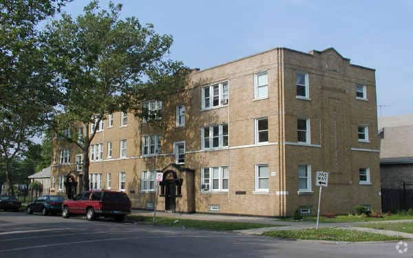
2642-2650 N Kilpatrick Ave offers a mixture of style and comfort. The address for this community is in Chicago on N. Kilpatrick Ave. From amenities to location, the leasing team is ready and waiting to help you find your perfect place. Be sure to come for a visit to see the available floorplan options. Contact us or drop by to talk about leasing your new apartment and find your new home at 2642-2650 N Kilpatrick Ave.
2642-2650 N Kilpatrick Ave is an apartment community located in Cook County and the 60639 ZIP Code. This area is served by the Chicago Public Schools attendance zone.
Located in the Avondale section of northwest Chicago just eight miles from the city center, Belmont Gardens has it all. Its location near the Pulaski Corridor and other popular neighborhoods has contributed to its popularity. Belmont Gardens features rentals to fit any potential resident, including walk-up apartments or townhomes in long-standing brick buildings.
West Diversey Avenue and Fullerton Avenue feature local restaurants, breakfast spots, cocktail bars, and Mexican eateries all within walking distance of one another. At the heart of the neighborhood is Kelvyn William Park, a popular gathering spot for residents during the warmer months of the year.
Learn more about living in Belmont GardensCompare neighborhood and city base rent averages by bedroom.
| Belmont Gardens | Chicago, IL | |
|---|---|---|
| Studio | $1,535 | $1,658 |
| 1 Bedroom | $1,181 | $2,054 |
| 2 Bedrooms | $1,693 | $2,599 |
| 3 Bedrooms | $1,586 | $3,112 |
| Colleges & Universities | Distance | ||
|---|---|---|---|
| Colleges & Universities | Distance | ||
| Drive: | 8 min | 3.7 mi | |
| Drive: | 10 min | 4.7 mi | |
| Drive: | 11 min | 5.1 mi | |
| Drive: | 13 min | 5.6 mi |


Transportation options available in Chicago include Logan Square Station, located 2.1 miles from 2642-2650 N Kilpatrick Ave. 2642-2650 N Kilpatrick Ave is near Chicago Midway International, located 10.1 miles or 21 minutes away, and Chicago O'Hare International, located 11.6 miles or 21 minutes away.
| Transit / Subway | Distance | ||
|---|---|---|---|
| Transit / Subway | Distance | ||
|
|
Drive: | 5 min | 2.1 mi |
|
|
Drive: | 5 min | 2.3 mi |
|
|
Drive: | 7 min | 3.0 mi |
|
|
Drive: | 7 min | 3.3 mi |
|
|
Drive: | 7 min | 3.4 mi |
| Commuter Rail | Distance | ||
|---|---|---|---|
| Commuter Rail | Distance | ||
|
|
Drive: | 3 min | 1.2 mi |
|
|
Drive: | 4 min | 1.2 mi |
|
|
Drive: | 5 min | 1.9 mi |
|
|
Drive: | 5 min | 2.1 mi |
|
|
Drive: | 6 min | 2.6 mi |
| Airports | Distance | ||
|---|---|---|---|
| Airports | Distance | ||
|
Chicago Midway International
|
Drive: | 21 min | 10.1 mi |
|
Chicago O'Hare International
|
Drive: | 21 min | 11.6 mi |
Scores provided by
Traffic
-Airport
-Businesses
-Scores provided by
HowLoud What is a Sound Score Rating? A Sound Score Rating aggregates noise caused by vehicle traffic, airplane traffic and local sources. How It WorksTime and distance from 2642-2650 N Kilpatrick Ave.
| Shopping Centers | Distance | ||
|---|---|---|---|
| Shopping Centers | Distance | ||
| Walk: | 7 min | 0.4 mi | |
| Walk: | 10 min | 0.6 mi | |
| Walk: | 11 min | 0.6 mi |
| Parks and Recreation | Distance | ||
|---|---|---|---|
| Parks and Recreation | Distance | ||
|
Kilbourn Park
|
Drive: | 4 min | 1.3 mi |
|
LaFollette Park
|
Drive: | 5 min | 2.3 mi |
|
Riis Park
|
Drive: | 5 min | 2.4 mi |
|
Portage Park
|
Drive: | 7 min | 3.3 mi |
|
Wonder Works Children's Museum
|
Drive: | 8 min | 3.6 mi |
| Hospitals | Distance | ||
|---|---|---|---|
| Hospitals | Distance | ||
| Drive: | 5 min | 2.4 mi | |
| Drive: | 7 min | 3.5 mi | |
| Drive: | 8 min | 4.0 mi |
| Military Bases | Distance | ||
|---|---|---|---|
| Military Bases | Distance | ||
| Drive: | 29 min | 19.3 mi | |
| Drive: | 42 min | 27.7 mi | |
| Drive: | 53 min | 32.7 mi |
What Are Walk Score®, Transit Score®, and Bike Score® Ratings?
Walk Score® measures the walkability of any address. Transit Score® measures access to public transit. Bike Score® measures the bikeability of any address.
What is a Sound Score Rating?
A Sound Score Rating aggregates noise caused by vehicle traffic, airplane traffic and local sources.
2642-2650 N Kilpatrick Ave
Chicago, IL 60639


