

$3,950 / Month
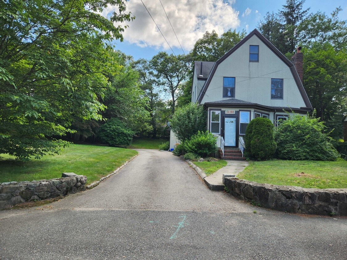
26 Oak St
Wellesley, MA 02482
Today
Favorites
857-869-8202
-
Bedrooms
3
-
Bathrooms
1.25
-
Square Feet
1,695 sq ft
-
Available
Available Aug 1
26 Oak St

Favorites
About This Home
$2,000 deposit,
Available Aug 1
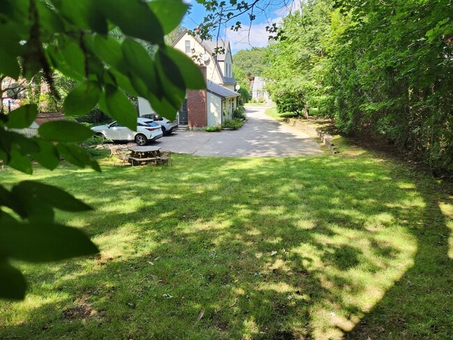
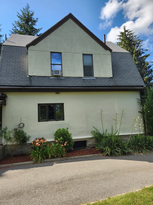
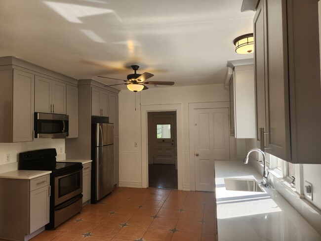
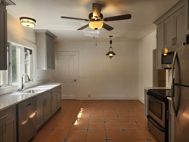
No fee. **AVAILABLE NOW** Attached single family home on large lot. 1,695 square feet of living space in fabulous location. Two blocks from the notable Sprague Elementary School. Can also walk a bit further to the Wellesley Middle School and High School known for their outstanding and supportive education. Minutes to Roche Brothers', Starbucks and the rest of the new Linden Square development shops and restaurants- The sports fields of the Sprague school are also close by. Walk to Commuter Rail, Wellesley Town Center and Wellesley College- a few blocks from entrance to Route 9. Easy access to route 16 and 128/95. Bordered by Needham, Natick, and Newton and close to I-90 Mass Pike. Front and back entries. First floor has large freshly updated eat-in kitchen with brand new cabinets, quartz countertop and dishwasher. Formal dining room, family room with working fireplace, laundry nook (W & D provided) and powder room and a foyer. Second floor has three generous bedrooms and a large full bath with marble floor. Freshly sanded and finished gleaming hardwood floors throughout. New energy efficient heating system. Updated High Efficiency Water Heater, high ceilings with crown molding. Hardwood floor throughout. Two off-street parking spaces. Lots of storage in basement and attic. Internet/cable lines. Quiet neighborhood. Landlord pays landscaping and snow removal. Forced air, gas heat. Wall A/C in master bedroom and window AC in rooms.
26 Oak St is a townhome located in Norfolk County and the 02482 ZIP Code. This area is served by the Wellesley attendance zone.
* Price shown is base rent and may not include non-optional fees and utilities.
Price, availability, fees, and any applicable rent special are subject to change without notice.
* Square footage definitions vary. Displayed square footage is approximate.
Townhome Features
- Washer/Dryer
- Washer/Dryer Hookup
- Dishwasher
Fees and Policies
The fees below are based on community-supplied data and may exclude additional fees and utilities.
- Cats Allowed
-
Fees not specified
-
Weight limit--
-
Pet Limit--
Contact
- Listed by Peggy
- Phone Number
- Contact
Location
Get Directions
Amenities
- Washer/Dryer
- Washer/Dryer Hookup
- Dishwasher
Just west of Boston and East of Worcester sits Metro West, a region that houses a group of towns and cities with significant historical backgrounds. A total of 19 municipalities make up the core of this community, but other municipalities are considered to be a part of the Interstate 495/Metro West Corridor.
Learn more about living in Metro West
Education
| Colleges & Universities | Distance | ||
|---|---|---|---|
| Colleges & Universities | Distance | ||
| Drive: | 5 min | 1.6 mi | |
| Drive: | 5 min | 2.2 mi | |
| Drive: | 15 min | 6.5 mi | |
| Drive: | 16 min | 8.7 mi |
26 Oak St is within 5 minutes or 1.6 miles from Wellesley College. It is also near Babson College and Brandeis University.
Schools


Public Elementary School
Grades K-5
287 Students
Attendance Zone
Public Elementary School
Grades PK-5
699 Students
Nearby
Public Middle School
Grades 6-8
922 Students
Attendance Zone
Public High School
Grades 9-12
1,412 Students
Attendance Zone
Private Elementary & Middle School
Grades PK-8
185 Students
Nearby
Private Middle & High School
Grades 6-12
475 Students
Nearby
School data provided by
 The GreatSchools Rating helps parents compare schools within a state based on a variety of school quality indicators and provides a helpful picture of how effectively each school serves all of its students. Ratings are on a scale of 1 (below average) to 10 (above average) and can include test scores, college readiness, academic progress, advanced courses, equity, discipline and attendance data. We also advise parents to visit schools, consider other information on school performance and programs, and consider family needs as part of the school selection process.
View GreatSchools Rating Methodology
Data provided by GreatSchools.org © 2025. All rights reserved.
View GreatSchools Rating Methodology
Data provided by GreatSchools.org © 2025. All rights reserved.
Transportation options available in Wellesley include Woodland Station, located 4.0 miles from 26 Oak St. 26 Oak St is near General Edward Lawrence Logan International, located 18.0 miles or 30 minutes away, and Worcester Regional, located 32.2 miles or 55 minutes away.
| Transit / Subway | Distance | ||
|---|---|---|---|
| Transit / Subway | Distance | ||
|
|
Drive: | 8 min | 4.0 mi |
|
|
Drive: | 9 min | 4.1 mi |
|
|
Drive: | 9 min | 4.7 mi |
|
|
Drive: | 10 min | 5.3 mi |
|
|
Drive: | 10 min | 5.5 mi |
| Commuter Rail | Distance | ||
|---|---|---|---|
| Commuter Rail | Distance | ||
|
|
Walk: | 8 min | 0.5 mi |
|
|
Drive: | 3 min | 1.5 mi |
|
|
Drive: | 6 min | 2.8 mi |
|
|
Drive: | 7 min | 3.5 mi |
|
|
Drive: | 9 min | 3.9 mi |
| Airports | Distance | ||
|---|---|---|---|
| Airports | Distance | ||
|
General Edward Lawrence Logan International
|
Drive: | 30 min | 18.0 mi |
|
Worcester Regional
|
Drive: | 55 min | 32.2 mi |
Time and distance from 26 Oak St.
| Shopping Centers | Distance | ||
|---|---|---|---|
| Shopping Centers | Distance | ||
| Walk: | 7 min | 0.4 mi | |
| Walk: | 9 min | 0.5 mi | |
| Walk: | 13 min | 0.7 mi |
26 Oak St has 3 shopping centers within 0.7 mile, which is about a 13-minute walk. The miles and minutes will be for the farthest away property.
| Parks and Recreation | Distance | ||
|---|---|---|---|
| Parks and Recreation | Distance | ||
|
Whitin Observatory
|
Walk: | 18 min | 1.0 mi |
|
Wellesley College Botanic Gardens
|
Drive: | 2 min | 1.2 mi |
|
Weezie's Garden for Children
|
Drive: | 8 min | 2.9 mi |
|
Elm Bank Reservation
|
Drive: | 8 min | 2.9 mi |
|
Horticultural Society at Elm Bank
|
Drive: | 9 min | 3.0 mi |
26 Oak St has 5 parks within 3.0 miles, including Whitin Observatory, Wellesley College Botanic Gardens, and Horticultural Society at Elm Bank.
| Hospitals | Distance | ||
|---|---|---|---|
| Hospitals | Distance | ||
| Drive: | 7 min | 3.8 mi | |
| Drive: | 8 min | 4.1 mi | |
| Drive: | 14 min | 7.0 mi |
26 Oak St has 3 hospitals within 7.0 miles, the nearest is Newton - Wellesley Hospital which is 3.8 miles away and a 7 minute drive.
| Military Bases | Distance | ||
|---|---|---|---|
| Military Bases | Distance | ||
| Drive: | 8 min | 4.1 mi | |
| Drive: | 25 min | 13.9 mi |
26 Oak St is 4.1 miles from US Military Reservation, and is convenient to other military bases, including Hanscom Air Force Base.
You May Also Like
Similar Rentals Nearby


What Are Walk Score®, Transit Score®, and Bike Score® Ratings?
Walk Score® measures the walkability of any address. Transit Score® measures access to public transit. Bike Score® measures the bikeability of any address.
What is a Sound Score Rating?
A Sound Score Rating aggregates noise caused by vehicle traffic, airplane traffic and local sources
26 Oak St
Wellesley, MA 02482