
$4,295
/ Month
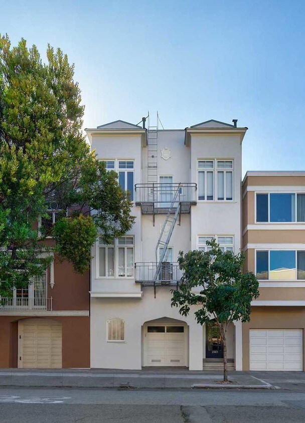
2563 Clay St Unit 9
San Francisco, CA 94115
Favorites
2563 Clay St Unit 9

Favorites
Check Back Soon for Upcoming Availability
| Beds | Baths | Average SF |
|---|---|---|
| 2 Bedrooms 2 Bedrooms 2 Br | 1 Bath 1 Bath 1 Ba | — |
About This Property
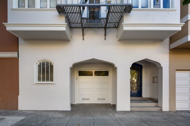
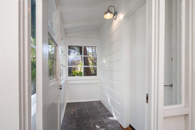
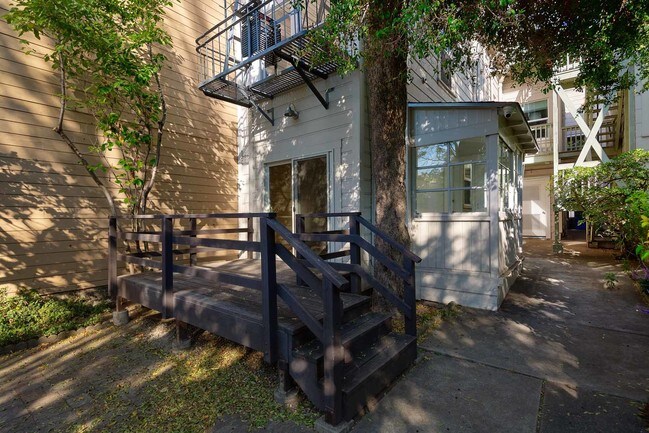
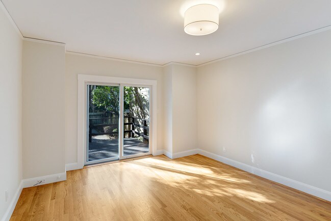
This charming building is located in Pacific Heights, one half block from Fillmore Street shops and restaurants and Alta Plaza Park. The extensively renovated 2BR/1BA garden apartment has an enclosed porch and private deck, extending your living space outdoors. The living room has hardwood floors and opens to the kitchen, which has stainless steel appliances including a dishwasher and microwave, custom cabinetry and quartz countertops. Arched hallway leads to the two bedrooms which have new carpet. New electrical and plumbing throughout. Total size is 800 sqft. Sorry No Pets. Parking space available for $200/month extra. Shared laundry in building. Owner pays water and garbage, tenant pays PGE and data. Available now, rent is $4295/month (rent controlled). One year lease, deposit is 1.5x rent. To view the apartment, please contact owner.
2563 Clay St is a condo located in San Francisco County and the 94115 ZIP Code. This area is served by the San Francisco Unified School District attendance zone.
2563 Clay St,
San Francisco,
CA
94115
Situated in northern San Francisco, Pacific Heights is a picturesque neighborhood known for its tranquil sophistication, Victorian architecture, and stunning views of the Golden Gate Bridge and the San Francisco Bay. Pacific Heights is a predominantly residential neighborhood, touting a host of apartments in colorful historic buildings as well as numerous extravagant homes along tree-lined streets.
Fillmore Street is the neighborhood’s major thoroughfare, regarded for its high-end boutique shopping and exceptional eateries. Pacific Heights exudes a peaceful atmosphere overall. Residents and visitors take to Alta Plaza Park and Lafayette Park to connect with nature in addition to the famous Presidio, which is adjacent to Pacific Heights. A walkable design along with access to public transit makes getting around from Pacific Heights a breeze.
Learn more about living in Pacific HeightsBelow are rent ranges for similar nearby apartments
Education
| Colleges & Universities | Distance | ||
|---|---|---|---|
| Colleges & Universities | Distance | ||
| Walk: | 12 min | 0.6 mi | |
| Drive: | 5 min | 1.7 mi | |
| Drive: | 5 min | 1.8 mi | |
| Drive: | 7 min | 2.5 mi |
2563 Clay St Unit 9 is within 12 minutes or 0.6 mile from UC San Francisco, Mount Zion. It is also near Academy of Art University and University of San Francisco.
Schools


Public Elementary School
Grades K-5
291 Students
Attendance Zone
Public Elementary & Middle School
Grades K-8
267 Students
Nearby
Public Elementary School
Grades K-5
296 Students
Nearby
Public High School
Grades 9-12
464 Students
Nearby
Private Elementary, Middle & High School
Grades 4-12
210 Students
Nearby
Private Elementary & Middle School
Grades K-8
414 Students
Nearby
Private Elementary, Middle & High School
Grades PK-12
431 Students
Nearby
School data provided by
 The GreatSchools Rating helps parents compare schools within a state based on a variety of school quality indicators and provides a helpful picture of how effectively each school serves all of its students. Ratings are on a scale of 1 (below average) to 10 (above average) and can include test scores, college readiness, academic progress, advanced courses, equity, discipline and attendance data. We also advise parents to visit schools, consider other information on school performance and programs, and consider family needs as part of the school selection process.
View GreatSchools Rating Methodology
Data provided by GreatSchools.org © 2026. All rights reserved.
View GreatSchools Rating Methodology
Data provided by GreatSchools.org © 2026. All rights reserved.
Transportation options available in San Francisco include Van Ness And California, located 0.8 mile from 2563 Clay St Unit 9. 2563 Clay St Unit 9 is near San Francisco International, located 15.0 miles or 25 minutes away, and Metro Oakland International, located 20.9 miles or 34 minutes away.
| Transit / Subway | Distance | ||
|---|---|---|---|
| Transit / Subway | Distance | ||
|
|
Walk: | 16 min | 0.8 mi |
|
|
Walk: | 19 min | 1.0 mi |
|
|
Walk: | 20 min | 1.1 mi |
| Drive: | 3 min | 1.2 mi | |
| Drive: | 4 min | 1.3 mi |
| Commuter Rail | Distance | ||
|---|---|---|---|
| Commuter Rail | Distance | ||
| Drive: | 8 min | 4.1 mi | |
| Drive: | 14 min | 7.2 mi | |
| Drive: | 20 min | 10.5 mi | |
|
|
Drive: | 21 min | 12.1 mi |
|
|
Drive: | 24 min | 12.6 mi |
| Airports | Distance | ||
|---|---|---|---|
| Airports | Distance | ||
|
San Francisco International
|
Drive: | 25 min | 15.0 mi |
|
Metro Oakland International
|
Drive: | 34 min | 20.9 mi |
Walkability Near 2563 Clay St San Francisco, CA 94115
Getting Around
 What do Walkability, Transit, Drivability, and Bikeability mean?
Walkability measures the walking distance to day-to-day needs.
Transit measures access to public transportation.
Drivability measures congestion, parking availability, and access to major roads.
Bikeability measures the suitability for cycling.
How It Works
What do Walkability, Transit, Drivability, and Bikeability mean?
Walkability measures the walking distance to day-to-day needs.
Transit measures access to public transportation.
Drivability measures congestion, parking availability, and access to major roads.
Bikeability measures the suitability for cycling.
How It Works
Exceptionally Walkable
Walkability
100
/ 100
Exceptional Public Transit
Transit
100
/ 100
Moderately Drivable
Drivability
60
/ 100
Moderately Bikeable
Bikeability
70
/ 100
Scores provided by
-
Soundscore™
-
/ 100
Traffic
-Airport
-Businesses
-Scores provided by
HowLoud What is a Sound Score Rating? A Sound Score Rating aggregates noise caused by vehicle traffic, airplane traffic and local sources. How It WorksTime and distance from 2563 Clay St Unit 9.
| Shopping Centers | Distance | ||
|---|---|---|---|
| Shopping Centers | Distance | ||
| Walk: | 12 min | 0.6 mi | |
| Drive: | 4 min | 1.2 mi |
2563 Clay St Unit 9 has 2 shopping centers within 1.2 miles, which is about a 4-minute drive. The miles and minutes will be for the farthest away property.
| Parks and Recreation | Distance | ||
|---|---|---|---|
| Parks and Recreation | Distance | ||
|
Exploratorium
|
Drive: | 4 min | 1.7 mi |
|
San Francisco Maritime National Historical Park
|
Drive: | 5 min | 2.1 mi |
|
Buena Vista Park
|
Drive: | 7 min | 2.3 mi |
|
Conservatory of Flowers
|
Drive: | 6 min | 2.3 mi |
|
Randall Museum
|
Drive: | 8 min | 2.8 mi |
2563 Clay St Unit 9 has 5 parks within 2.8 miles, including Exploratorium, San Francisco Maritime National Historical Park, and Buena Vista Park.
| Hospitals | Distance | ||
|---|---|---|---|
| Hospitals | Distance | ||
| Drive: | 3 min | 1.2 mi | |
| Drive: | 4 min | 1.3 mi | |
| Drive: | 3 min | 1.3 mi |
2563 Clay St Unit 9 has 3 hospitals within 1.3 miles, the nearest is Saint Francis Memorial Hospital which is 1.2 miles away and a 3 minute drive.
| Military Bases | Distance | ||
|---|---|---|---|
| Military Bases | Distance | ||
| Drive: | 12 min | 4.0 mi | |
| Drive: | 13 min | 4.4 mi | |
| Drive: | 17 min | 7.1 mi |
2563 Clay St Unit 9 has 3 military bases within 7.1 miles, the nearest is East Fort Miley which is 4.0 miles away and a 12 minute drive.
You May Also Like
Similar Rentals Nearby


What Are Walk Score®, Transit Score®, and Bike Score® Ratings?
Walk Score® measures the walkability of any address. Transit Score® measures access to public transit. Bike Score® measures the bikeability of any address.
What is a Sound Score Rating?
A Sound Score Rating aggregates noise caused by vehicle traffic, airplane traffic and local sources.

2563 Clay St
San Francisco, CA 94115