


$845
/ Month
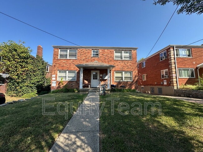
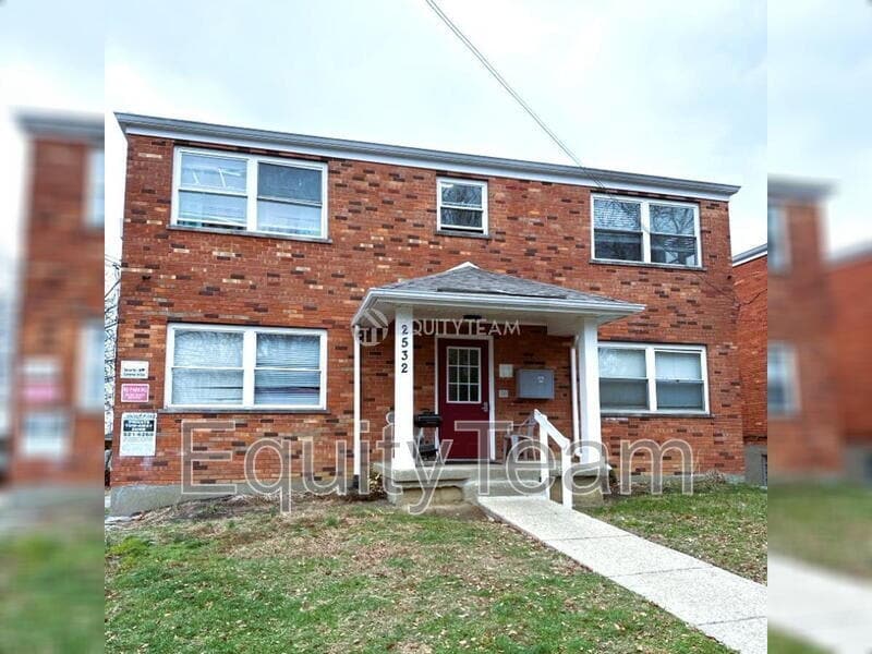
2532 Flanigan Ct Unit Apt 4
Cincinnati, OH 45239
Today
|
Edit
Favorites
513-443-5862
-
Bedrooms
1
-
Bathrooms
1
-
Square Feet
--
-
Available
Available Now
2532 Flanigan Ct Unit Apt 4

Favorites
About This Home
$845 deposit,
Available Now
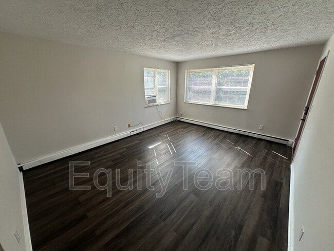
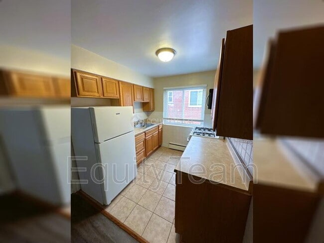
Recently updated 1 Bed/ 1 Bath Apartment in Mt Airy, just east of Colerain Ave. Conveniently located close to schools, entertainment, shopping, and restaurants. This home features: Fresh paint; new LVT flooring throughout; updated kitchen with appliances; renovated bathroom; shared laundry room; on-street parking, and more! Virtual Tour Link: *No pets allowed* In addition to rent, there is a mandatory Resident Benefit Package ($29 per month), which includes: - $100,000 liability coverage on the property - $10,000 in tenant personal property coverage - HVAC filters delivered to your unit to be changed out quarterly (if applicable) - Free ACH payments - Credit reporting of rent payments to help improve credit - Tenant & Maintenance Portals -Resident Concierge Service to help tenants save money on frequently used services *Multiple Security Deposit options/alternatives available *See Application Terms & Conditions on for other charges *$49 Application Fee per adult
2532 Flanigan Ct is a condo located in Hamilton County and the 45239 ZIP Code. This area is served by the Cincinnati Public Schools attendance zone.
* Price shown is base rent. Excludes user-selected optional fees and variable or usage-based fees and required charges due at or prior to move-in or at move-out. Price, availability, fees, and any applicable rent special are subject to change without notice.
* Square footage definitions vary. Displayed square footage is approximate.
Fees and Policies
The fees below are based on community-supplied data and may exclude additional fees and utilities.
- Parking
-
Street--
Contact
- Phone Number
- Contact
Location
Get Directions
Mount Airy is a classic suburban neighborhood with peaceful streets lined with single-family homes. Interstate 74 and Highway 22 makes the seven mile drive into Downtown Cincinnati and beyond accessible, but Mount Airy has a lot to offer from within. Its southern border encompasses Mount Airy Forest, which provides residents with outdoor fun. There are also a few fast food restaurants within the neighborhood, but residents can easily travel to the surrounding areas or into downtown for a diverse selection of restaurants. Renters will find that they have a few affordable options of apartments in longstanding brick buildings to choose from.
Learn more about living in Mount Airy
Education
| Colleges & Universities | Distance | ||
|---|---|---|---|
| Colleges & Universities | Distance | ||
| Drive: | 15 min | 5.7 mi | |
| Drive: | 16 min | 7.3 mi | |
| Drive: | 18 min | 7.7 mi | |
| Drive: | 21 min | 9.3 mi |
2532 Flanigan Ct Unit Apt 4 is within 15 minutes or 5.7 miles from Cincinnati State. It is also near University of Cincinnati and Univ. of Cincinnati, Medical.
Schools


Public Elementary & Middle School
Grades PK-7
569 Students
Attendance Zone
Public Middle & High School
Grades 7-12
760 Students
Attendance Zone
Private Elementary & Middle School
Grades PK-8
105 Students
Nearby
Private High School
Grades 9-12
568 Students
Nearby
School data provided by
 The GreatSchools Rating helps parents compare schools within a state based on a variety of school quality indicators and provides a helpful picture of how effectively each school serves all of its students. Ratings are on a scale of 1 (below average) to 10 (above average) and can include test scores, college readiness, academic progress, advanced courses, equity, discipline and attendance data. We also advise parents to visit schools, consider other information on school performance and programs, and consider family needs as part of the school selection process.
View GreatSchools Rating Methodology
Data provided by GreatSchools.org © 2025. All rights reserved.
View GreatSchools Rating Methodology
Data provided by GreatSchools.org © 2025. All rights reserved.
Transportation options available in Cincinnati include Brewery District Station, Elm & Henry, located 8.0 miles from 2532 Flanigan Ct Unit Apt 4. 2532 Flanigan Ct Unit Apt 4 is near Cincinnati/Northern Kentucky International, located 22.0 miles or 41 minutes away.
| Transit / Subway | Distance | ||
|---|---|---|---|
| Transit / Subway | Distance | ||
| Drive: | 17 min | 8.0 mi | |
| Drive: | 17 min | 8.1 mi | |
| Drive: | 17 min | 8.2 mi | |
| Drive: | 18 min | 8.2 mi | |
| Drive: | 18 min | 8.3 mi |
| Commuter Rail | Distance | ||
|---|---|---|---|
| Commuter Rail | Distance | ||
|
|
Drive: | 17 min | 8.0 mi |
| Airports | Distance | ||
|---|---|---|---|
| Airports | Distance | ||
|
Cincinnati/Northern Kentucky International
|
Drive: | 41 min | 22.0 mi |
Time and distance from 2532 Flanigan Ct Unit Apt 4.
| Shopping Centers | Distance | ||
|---|---|---|---|
| Shopping Centers | Distance | ||
| Walk: | 11 min | 0.6 mi | |
| Walk: | 12 min | 0.6 mi | |
| Drive: | 4 min | 1.5 mi |
2532 Flanigan Ct Unit Apt 4 has 3 shopping centers within 1.5 miles, which is about a 4-minute walk. The miles and minutes will be for the farthest away property.
| Parks and Recreation | Distance | ||
|---|---|---|---|
| Parks and Recreation | Distance | ||
|
LaBoiteaux Woods
|
Drive: | 6 min | 2.5 mi |
|
Farbach-Werner Nature Preserve
|
Drive: | 7 min | 2.7 mi |
|
Mt. Airy Forest
|
Drive: | 8 min | 3.0 mi |
|
Buttercup Valley
|
Drive: | 9 min | 3.5 mi |
|
Caldwell Preserve
|
Drive: | 12 min | 5.2 mi |
2532 Flanigan Ct Unit Apt 4 has 5 parks within 5.2 miles, including LaBoiteaux Woods, Farbach-Werner Nature Preserve, and Mt. Airy Forest.
| Hospitals | Distance | ||
|---|---|---|---|
| Hospitals | Distance | ||
| Drive: | 9 min | 3.6 mi | |
| Drive: | 15 min | 6.4 mi | |
| Drive: | 15 min | 6.6 mi |
2532 Flanigan Ct Unit Apt 4 has 3 hospitals within 6.6 miles, the nearest is Mercy Health - West Hospital which is 3.6 miles away and a 9 minute drive.
| Military Bases | Distance | ||
|---|---|---|---|
| Military Bases | Distance | ||
| Drive: | 70 min | 53.9 mi | |
| Drive: | 76 min | 59.0 mi | |
| Drive: | 79 min | 62.3 mi |
2532 Flanigan Ct Unit Apt 4 has 3 military bases within 62.3 miles, the nearest is Gentile Air Force Station which is 53.9 miles away and a 70 minute drive.
You May Also Like
Similar Rentals Nearby


What Are Walk Score®, Transit Score®, and Bike Score® Ratings?
Walk Score® measures the walkability of any address. Transit Score® measures access to public transit. Bike Score® measures the bikeability of any address.
What is a Sound Score Rating?
A Sound Score Rating aggregates noise caused by vehicle traffic, airplane traffic and local sources
2532 Flanigan Ct
Cincinnati, OH 45239