
$2,100
Total Monthly Price
250 Chilpancingo Pky Unit #5
Pleasant Hill, CA 94523
Today
|
Edit
Favorites
279-237-2002
-
Bedrooms
2
-
Bathrooms
1
-
Square Feet
801 sq ft
-
Available
Available Mar 21
Highlights
- Pool
- Smoke Free
- Wheelchair Accessible
250 Chilpancingo Pky Unit #5

Favorites
About This Home
12 Month Lease,
$2,100 deposit,
Available Mar 21
One covered parking, and close to Highway 680, quiet location. This is #5
250 Chilpancingo Pky is a condo located in Contra Costa County and the 94523 ZIP Code.
* Price shown is total price based on community-supplied monthly required fees. Excludes user-selected optional fees and variable or usage-based fees and required charges due at or prior to move-in or at move-out. Price, availability, fees, and any applicable rent special are subject to change without notice.
* Square footage definitions vary. Displayed square footage is approximate.
Condo Features
- Air Conditioning
- Smoke Free
- Dishwasher
- Laundry Facilities
- Wheelchair Accessible
- Storage Space
- Pool
Fees and Policies
The fees listed below are community-provided and may exclude utilities or add-ons. All payments are made directly to the property and are non-refundable unless otherwise specified.
- Parking
-
Covered--
Details
Utilities Included
-
Gas
-
Electricity
Contact
- Phone Number
- Contact
Location
Get Directions
Pleasant Hill is exactly what you’d expect: a pleasant community in the California hills. This suburb offers urban amenities and small-town charm, along with upscale rentals ranging from single-family homes to modern apartments. A charming outdoor shopping center sits in the heart of downtown, along with neighborhood parks, movie theaters, and top-notch public schools like Sequoia Middle. Pleasant Hill offers proximity to even more shopping and entertainment options like Sunvalley Shopping Center and Six Flags in Concord. Suisun Bay is only a few miles north of town, and Walnut Creek sits directly south. Residents of this upscale suburb also have easy access to Berkeley, Oakland, Richmond, and San Francisco thanks to Interstate 680 and State Route 24.
Learn more about living in Pleasant Hill
Education
| Colleges & Universities | Distance | ||
|---|---|---|---|
| Colleges & Universities | Distance | ||
| Drive: | 5 min | 1.8 mi | |
| Drive: | 23 min | 12.4 mi | |
| Drive: | 24 min | 15.2 mi | |
| Drive: | 30 min | 19.5 mi |
250 Chilpancingo Pky Unit #5 is within 5 minutes or 1.8 miles from Diablo Valley, Pleasant Hill. It is also near Saint Marys Coll. of Calif. and Los Medanos College, Pittsburg.
Transportation options available in Pleasant Hill include Concord, located 3.0 miles from 250 Chilpancingo Pky Unit #5. 250 Chilpancingo Pky Unit #5 is near Metro Oakland International, located 29.3 miles or 40 minutes away, and San Francisco International, located 41.3 miles or 58 minutes away.
| Transit / Subway | Distance | ||
|---|---|---|---|
| Transit / Subway | Distance | ||
|
|
Drive: | 7 min | 3.0 mi |
|
|
Drive: | 8 min | 4.4 mi |
|
|
Drive: | 8 min | 4.8 mi |
|
|
Drive: | 9 min | 6.0 mi |
|
|
Drive: | 12 min | 9.3 mi |
| Commuter Rail | Distance | ||
|---|---|---|---|
| Commuter Rail | Distance | ||
|
|
Drive: | 11 min | 7.4 mi |
| Drive: | 30 min | 20.7 mi | |
|
|
Drive: | 29 min | 22.4 mi |
| Drive: | 32 min | 22.9 mi | |
|
|
Drive: | 31 min | 23.9 mi |
| Airports | Distance | ||
|---|---|---|---|
| Airports | Distance | ||
|
Metro Oakland International
|
Drive: | 40 min | 29.3 mi |
|
San Francisco International
|
Drive: | 58 min | 41.3 mi |
Time and distance from 250 Chilpancingo Pky Unit #5.
| Shopping Centers | Distance | ||
|---|---|---|---|
| Shopping Centers | Distance | ||
| Walk: | 5 min | 0.3 mi | |
| Walk: | 7 min | 0.4 mi | |
| Walk: | 10 min | 0.5 mi |
250 Chilpancingo Pky Unit #5 has 3 shopping centers within 0.5 mile, which is about a 10-minute walk. The miles and minutes will be for the farthest away property.
| Parks and Recreation | Distance | ||
|---|---|---|---|
| Parks and Recreation | Distance | ||
|
Markham Nature Park and Arboretum
|
Drive: | 12 min | 4.6 mi |
|
Larkey Park
|
Drive: | 8 min | 5.1 mi |
|
Lindsay Wildlife Museum
|
Drive: | 9 min | 5.1 mi |
|
Waterbird Regional Preserve
|
Drive: | 9 min | 6.0 mi |
|
John Muir National Historic Site
|
Drive: | 12 min | 6.2 mi |
250 Chilpancingo Pky Unit #5 has 5 parks within 6.2 miles, including John Muir National Historic Site, Lindsay Wildlife Museum, and Larkey Park.
| Hospitals | Distance | ||
|---|---|---|---|
| Hospitals | Distance | ||
| Drive: | 7 min | 2.9 mi | |
| Drive: | 6 min | 3.0 mi | |
| Drive: | 11 min | 6.4 mi |
250 Chilpancingo Pky Unit #5 has 3 hospitals within 6.4 miles, the nearest is John Muir Medical Center - Concord Campus which is 2.9 miles away and a 7 minute drive.
Amenities
- Air Conditioning
- Smoke Free
- Dishwasher
- Laundry Facilities
- Wheelchair Accessible
- Storage Space
- Pool
250 Chilpancingo Pky Unit #5 Photos
-
-
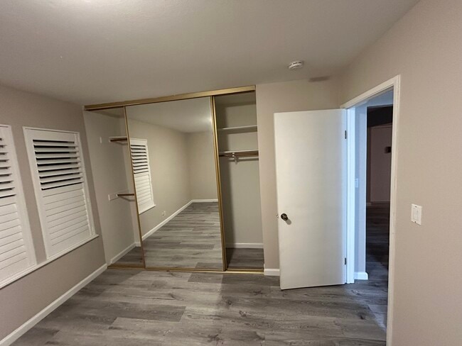
Main bedroom
-
-
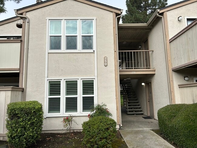
Front of #5
-
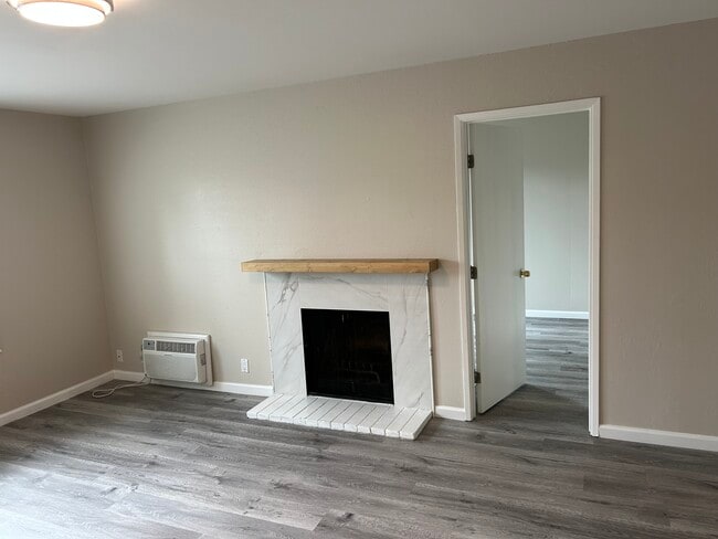
Living room
-
Kitchen
-
Kitchen
-
Kitchen and living room
-
Bedroom
What Are Walk Score®, Transit Score®, and Bike Score® Ratings?
Walk Score® measures the walkability of any address. Transit Score® measures access to public transit. Bike Score® measures the bikeability of any address.
What is a Sound Score Rating?
A Sound Score Rating aggregates noise caused by vehicle traffic, airplane traffic and local sources.
250 Chilpancingo Pky
Pleasant Hill, CA 94523