

$5,000 / Month
2470 Wexford Ave
South San Francisco, CA 94080
1 Day Ago
Favorites
415-505-0303
-
Bedrooms
4
-
Bathrooms
2.5
-
Square Feet
1,920 sq ft
-
Available
Available Now
2470 Wexford Ave

Favorites
About This Home
Available Now
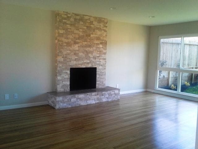
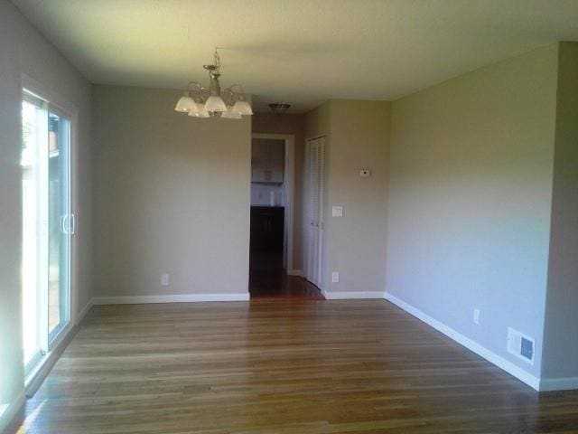
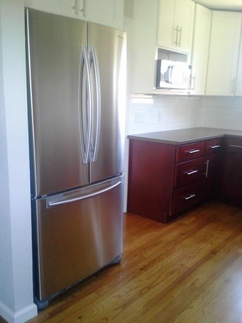
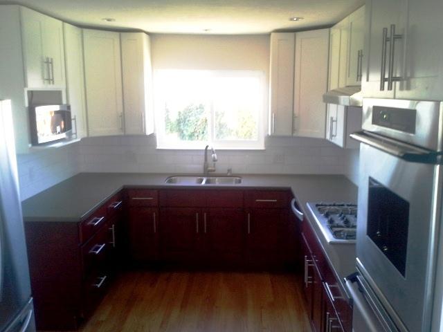
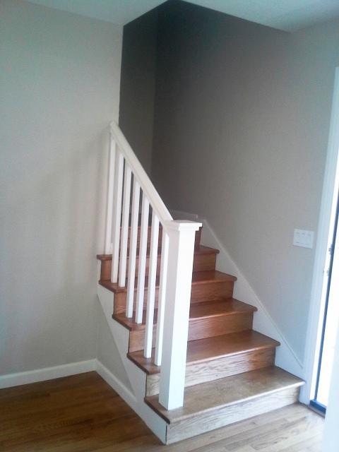
APS93400748 - **** We have open house on 7/8/2017 Saturday 10:00AM. **** Please come to visit and contact Henry Low. This single family house consists of 4 bedrooms and 2.5 baths, including a newly kitchen appliance with range, refrigerator and dishwasher. Big windows in the living room catch the sun light and there is a great view in the yard. Hardwood floor throughout the whole house with large walk-in closet in master bedroom. Two-car attached garage, side-by-side parking. Easy access Highway 280 & El Camino Real. Good school district area. Lease Term: min 1 year / no pet / no smoking Tenant pays: Gas, Electricity, Garbage, Water & Sewer Please go to our website for the online application - ;unitid=64537&buildingid=23424 and click "Apply Now". Upon completion of filling in your application form, could you please send in one copy of the following documents by email- . - W2 of last year (2016) or tax return if you are self employment; - last 2 pay stubs or income statement; - current bank statement - a copy of ID/Driver's License We will review your application and all above documents together, and will run the Credit and Criminal Background Check. The non-refundable administration fee is $35 per adult. Cash or credit card is accepted. Rental Requirement - please refer our "Standard Criteria for Tenant Selection". If tenant cannot meet all the criteria, Landlord will consider co-signer, guarantor or letters for exceptional approval. Henry Low (BRE#00852797) Prime Metropolis Properties, Inc DBA Land & Property Investment 950 Taraval Street, San Francisco, CA 94116
2470 Wexford Ave is a house located in San Mateo County and the 94080 ZIP Code. This area is served by the South San Francisco Unified attendance zone.
* Price shown is base rent and may not include non-optional fees and utilities.
Price, availability, fees, and any applicable rent special are subject to change without notice.
* Square footage definitions vary. Displayed square footage is approximate.
Contact
- Phone Number
- Contact
Location
Get Directions
Folks in South San Francisco have easy access to The City via I-280, the 101, or BART rail service. This fact, coupled with the much lower crime rate and the area’s many excellent schools, makes South San Francisco apartments an appealing option for commuters, particularly those raising families.
Although primarily a residential community, South San Francisco does have a fairly active downtown scene, with much of the dining and entertainment centered around the intersection of Grande Avenue and Linden Avenue and shopping centers on the south side of town.
Many parks and nature preserves are scattered around the area, including the huge Sweeney Ridge and Fairway Park just to the west of the city limits. San Francisco International Airport sits directly south of town, making it highly convenient to travel anywhere.
Learn more about living in South San Francisco
Education
| Colleges & Universities | Distance | ||
|---|---|---|---|
| Colleges & Universities | Distance | ||
| Drive: | 6 min | 1.6 mi | |
| Drive: | 12 min | 7.3 mi | |
| Drive: | 12 min | 7.7 mi | |
| Drive: | 18 min | 9.9 mi |
2470 Wexford Ave is within 6 minutes or 1.6 miles from Skyline College. It is also near City College of San Francisco and San Francisco State University.
Schools


Public Elementary School
Grades K-5
531 Students
Attendance Zone
Public Elementary School
Grades K-5
394 Students
Nearby
Public Middle School
Grades 6-8
491 Students
Attendance Zone
Public High School
Grades 9-12
1,280 Students
Attendance Zone
Private Elementary & Middle School
Grades PK-8
586 Students
Nearby
Private Elementary, Middle & High School
Grades 1-12
Nearby
School data provided by
 The GreatSchools Rating helps parents compare schools within a state based on a variety of school quality indicators and provides a helpful picture of how effectively each school serves all of its students. Ratings are on a scale of 1 (below average) to 10 (above average) and can include test scores, college readiness, academic progress, advanced courses, equity, discipline and attendance data. We also advise parents to visit schools, consider other information on school performance and programs, and consider family needs as part of the school selection process.
View GreatSchools Rating Methodology
Data provided by GreatSchools.org © 2025. All rights reserved.
View GreatSchools Rating Methodology
Data provided by GreatSchools.org © 2025. All rights reserved.
Transportation options available in South San Francisco include South San Francisco Station, located 2.7 miles from 2470 Wexford Ave. 2470 Wexford Ave is near San Francisco International, located 6.1 miles or 12 minutes away, and Metro Oakland International, located 32.3 miles or 45 minutes away.
| Transit / Subway | Distance | ||
|---|---|---|---|
| Transit / Subway | Distance | ||
|
|
Drive: | 6 min | 2.7 mi |
|
|
Drive: | 6 min | 2.7 mi |
|
|
Drive: | 7 min | 3.4 mi |
| Drive: | 8 min | 4.4 mi | |
|
|
Drive: | 9 min | 4.9 mi |
| Commuter Rail | Distance | ||
|---|---|---|---|
| Commuter Rail | Distance | ||
| Drive: | 7 min | 3.5 mi | |
| Drive: | 8 min | 4.0 mi | |
| Drive: | 12 min | 7.0 mi | |
| Drive: | 13 min | 8.0 mi | |
| Drive: | 15 min | 8.4 mi |
| Airports | Distance | ||
|---|---|---|---|
| Airports | Distance | ||
|
San Francisco International
|
Drive: | 12 min | 6.1 mi |
|
Metro Oakland International
|
Drive: | 45 min | 32.3 mi |
Time and distance from 2470 Wexford Ave.
| Shopping Centers | Distance | ||
|---|---|---|---|
| Shopping Centers | Distance | ||
| Walk: | 11 min | 0.6 mi | |
| Walk: | 14 min | 0.7 mi | |
| Walk: | 16 min | 0.8 mi |
2470 Wexford Ave has 3 shopping centers within 0.8 mile, which is about a 16-minute walk. The miles and minutes will be for the farthest away property.
| Parks and Recreation | Distance | ||
|---|---|---|---|
| Parks and Recreation | Distance | ||
|
Pacifica State Beach
|
Drive: | 11 min | 5.7 mi |
|
San Pedro Valley Park
|
Drive: | 18 min | 7.9 mi |
|
Charles F. Hagar Planetarium
|
Drive: | 14 min | 8.0 mi |
|
San Francisco State Univ. Observatory
|
Drive: | 14 min | 8.0 mi |
|
San Bruno Mountain State Park
|
Drive: | 18 min | 8.4 mi |
2470 Wexford Ave has 5 parks within 8.4 miles, including San Bruno Mountain State Park, Pacifica State Beach, and Charles F. Hagar Planetarium.
| Hospitals | Distance | ||
|---|---|---|---|
| Hospitals | Distance | ||
| Drive: | 5 min | 2.1 mi | |
| Drive: | 8 min | 3.6 mi | |
| Drive: | 11 min | 6.5 mi |
2470 Wexford Ave has 3 hospitals within 6.5 miles, the nearest is Kaiser Foundation Hospital - South San Francisco which is 2.1 miles away and a 5 minute drive.
| Military Bases | Distance | ||
|---|---|---|---|
| Military Bases | Distance | ||
| Drive: | 25 min | 11.9 mi | |
| Drive: | 26 min | 12.5 mi |
2470 Wexford Ave is 11.9 miles from East Fort Miley, and is convenient to other military bases, including West Fort Miley.
You May Also Like
Similar Rentals Nearby


What Are Walk Score®, Transit Score®, and Bike Score® Ratings?
Walk Score® measures the walkability of any address. Transit Score® measures access to public transit. Bike Score® measures the bikeability of any address.
What is a Sound Score Rating?
A Sound Score Rating aggregates noise caused by vehicle traffic, airplane traffic and local sources
2470 Wexford Ave
South San Francisco, CA 94080