

$2,000
/ Month
24420 W Nicklaus Dr
Santa Clarita, CA 91355
Favorites
24420 W Nicklaus Dr

Favorites
Check Back Soon for Upcoming Availability
| Beds | Baths | Average SF |
|---|---|---|
| 3 Bedrooms 3 Bedrooms 3 Br | 2 Baths 2 Baths 2 Ba | — |
About This Property
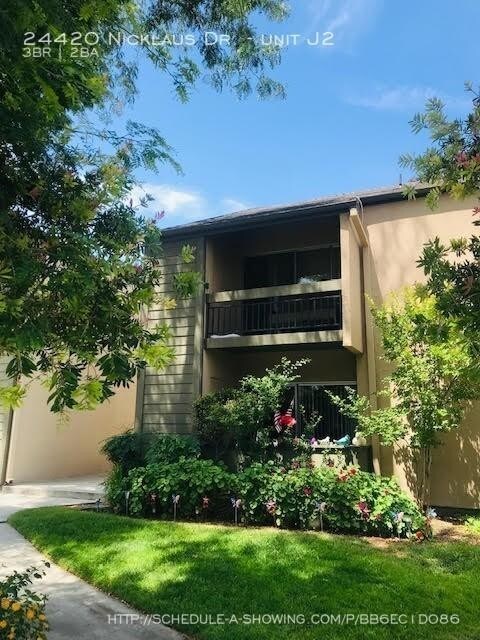
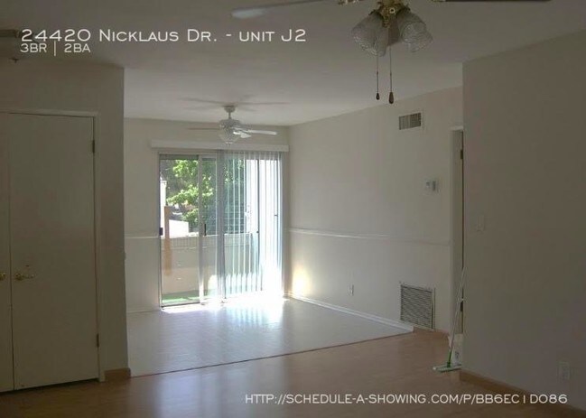
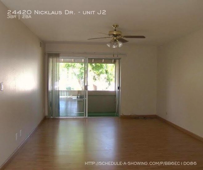
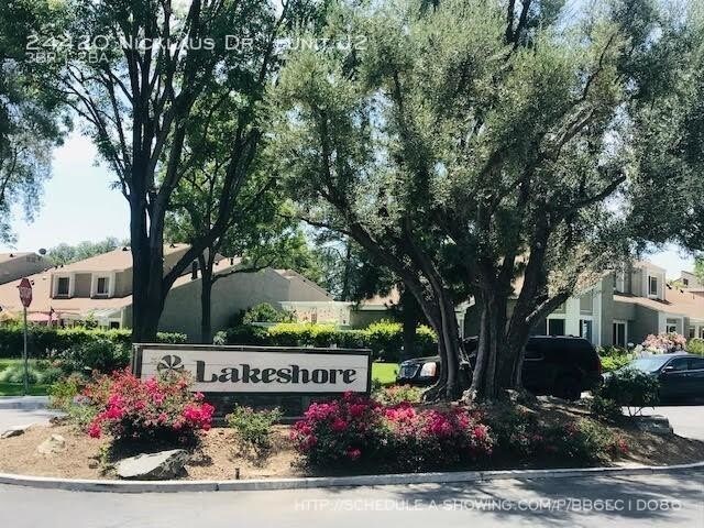
---- SCHEDULE A SHOWING ONLINE AT: showmojo.com/lt/bb6ec1d086 ---- This 3-Bedroom 2-Bath Upper Unit Condo at the Lakeshore community in Valencia will be Available on Aug 1st. Entryway opens into a spacious living room with wood laminate flooring, ceiling fan, vertical blinds and a sliding glass door leading to a balcony. The kitchen is nice and bright with a stove, dishwasher, microwave and refrigerator and white cabinets. The dining area off the kitchen has a ceiling fan, vertical blinds and a sliding glass door leading to a second balcony. Storage closet in the living room. Two guest bedrooms with walk in closets. Full guest bathroom. The Master bedroom has ceiling fan, walk in closet and full bathroom. On-site laundry units, comes with 2 carport parking spaces, 2 parking permits. Monthly rent includes HOA fees, Water, and Trash.This community has a small lakes, pool, tennis courts, basketball court and a playground. This community is located close to Vista Valencia Golf Course, easy access to Shopping, Dining, Freeways, CalArts, and The College of the Canyon. Pets are welcomed with additional pet deposit. Move-in costs include first month\'s rent and security deposit (one month\'s rent). Application fee of $42.00 per applicant. To schedule a viewing appointment, call (661) 367-8280 or (818) 471-4272 or visit valleywideleasing.com/available-for-lease. PLEASE DO NOT DISTURB CURRENT OCCUPANTS - NO TRESPASSING Community Playground Community Pool Facility Laundry Room Tennis Courts
24420 W Nicklaus Dr is an apartment community located in Los Angeles County and the 91355 ZIP Code.
24420 W Nicklaus Dr,
Santa Clarita,
CA
91355
Situated in Southern California, Santa Clarita Valley is an opulent suburb surrounded by nature preserves. The northern section of the region encompasses Castaic Lake State Recreation Park, while the eastern and western sides of the area are bordered by the Santa Clarita Woodlands Park and the Golden Valley Ranch Open Space. Also located in the valley are meandering trails that follow along the river and connect to scenic community parks. Located just 35 miles north of Los Angeles, Santa Clarita offers more than the great outdoors. Places like Six Flags Magic Mountain, sprawling golf courses, and premier shopping at plazas like Westfield Valencia Town Center are all located within Santa Clarita Valley. More shopping and retail centers can be found off Lyons Avenue and Soledad Canyon Road, while Main Street’s locally owned cafes, specialty shops, and restaurants provide a nice contrast to large commercial plazas.
Learn more about living in Santa Clarita Valley
Education
| Colleges & Universities | Distance | ||
|---|---|---|---|
| Colleges & Universities | Distance | ||
| Drive: | 7 min | 2.3 mi | |
| Drive: | 18 min | 13.5 mi | |
| Drive: | 25 min | 14.9 mi | |
| Drive: | 35 min | 26.8 mi |
24420 W Nicklaus Dr is within 7 minutes or 2.3 miles from College of the Canyons. It is also near Mission College and Cal State Northridge.
Walkability Near 24420 W Nicklaus Dr Santa Clarita, CA 91355
Getting Around
 What do Walkability, Transit, Drivability, and Bikeability mean?
Walkability measures the walking distance to day-to-day needs.
Transit measures access to public transportation.
Drivability measures congestion, parking availability, and access to major roads.
Bikeability measures the suitability for cycling.
How It Works
What do Walkability, Transit, Drivability, and Bikeability mean?
Walkability measures the walking distance to day-to-day needs.
Transit measures access to public transportation.
Drivability measures congestion, parking availability, and access to major roads.
Bikeability measures the suitability for cycling.
How It Works
Fairly Walkable
Walkability
40
/ 100
Limited Public Transit
Transit
30
/ 100
Exceptionally Drivable
Drivability
100
/ 100
Fairly Bikeable
Bikeability
50
/ 100
Scores provided by
-
Soundscore™
-
/ 100
Traffic
-Airport
-Businesses
-Scores provided by
HowLoud What is a Sound Score Rating? A Sound Score Rating aggregates noise caused by vehicle traffic, airplane traffic and local sources. How It WorksYou May Also Like
-
Living at NoHo
11059 McCormick St
North Hollywood, CA 91601
$3,729 - $3,924 Total Monthly Price
3 Br 18.9 mi
-
Avalon Burbank
350 S San Fernando Blvd
Burbank, CA 91502
$4,110 - $4,410
3 Br 20.6 mi
-
ZEN Hollywood
1825 N Las Palmas Ave
Los Angeles, CA 90028
$4,995 - $7,195 Total Monthly Price
3 Br 12 Month Lease 23.5 mi
Similar Rentals Nearby
-
-
-
-
-
-
-
3 Beds$3,814+Total Monthly Price12 Month LeaseTotal Monthly Price NewPrices include base rent and required monthly fees of $8. Variable costs based on usage may apply.Base Rent:3 Beds$3,805+Specials
Pets Allowed Fitness Center Pool Dishwasher Refrigerator In Unit Washer & Dryer
-
-
-


What Are Walk Score®, Transit Score®, and Bike Score® Ratings?
Walk Score® measures the walkability of any address. Transit Score® measures access to public transit. Bike Score® measures the bikeability of any address.
What is a Sound Score Rating?
A Sound Score Rating aggregates noise caused by vehicle traffic, airplane traffic and local sources.
24420 W Nicklaus Dr
Santa Clarita, CA 91355