
$2,395
/ Month
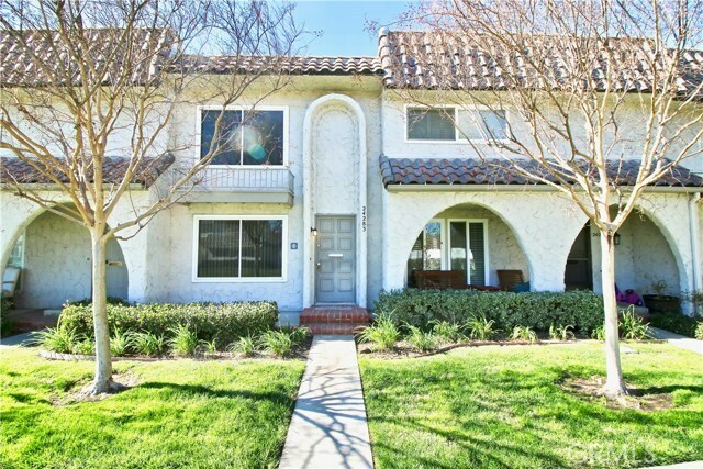
24283 La Glorita Cir
Santa Clarita, CA 91321
Favorites
24283 La Glorita Cir

Favorites
Check Back Soon for Upcoming Availability
| Beds | Baths | Average SF |
|---|---|---|
| 2 Bedrooms 2 Bedrooms 2 Br | 2 Baths 2 Baths 2 Ba | 988 SF |
Fees and Policies
The fees listed below are community-provided and may exclude utilities or add-ons. All payments are made directly to the property and are non-refundable unless otherwise specified.
About This Property
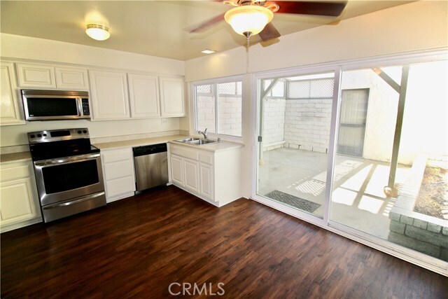
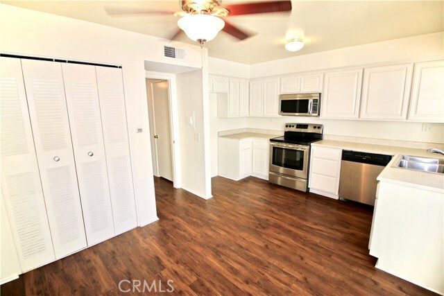
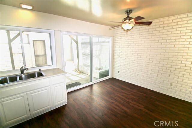
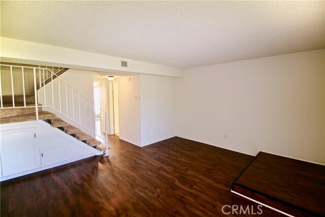
Privately owned 988 sqft two-story townhome in park-like community. Large living room, modern kitchen with stainless appliances, dining area, and guest 1/2 bath, all on first floor. Upstairs are two bedrooms with a shared full bath. Bright open kitchen with dishwasher, gas stove, and built-in microwave. Central air/heat, hardwood flooring throughout downstairs, and upgraded cut-pile carpeting upstairs. Middle unit near rear of complex with fenced patio, connected 2-car garage, and laundry hookups for full-size side-by-side washer and dryer. $3395/m base rent, less $1000/m discount with 12 month lease.
24283 La Glorita Cir is a townhome located in Los Angeles County and the 91321 ZIP Code. This area is served by the William S. Hart Union High School District attendance zone.
Townhome Features
- Air Conditioning
- Heating
24283 La Glorita Cir,
Santa Clarita,
CA
91321
Situated in Southern California, Santa Clarita Valley is an opulent suburb surrounded by nature preserves. The northern section of the region encompasses Castaic Lake State Recreation Park, while the eastern and western sides of the area are bordered by the Santa Clarita Woodlands Park and the Golden Valley Ranch Open Space. Also located in the valley are meandering trails that follow along the river and connect to scenic community parks. Located just 35 miles north of Los Angeles, Santa Clarita offers more than the great outdoors. Places like Six Flags Magic Mountain, sprawling golf courses, and premier shopping at plazas like Westfield Valencia Town Center are all located within Santa Clarita Valley. More shopping and retail centers can be found off Lyons Avenue and Soledad Canyon Road, while Main Street’s locally owned cafes, specialty shops, and restaurants provide a nice contrast to large commercial plazas.
Learn more about living in Santa Clarita Valley
Amenities
- Air Conditioning
- Heating
Education
| Colleges & Universities | Distance | ||
|---|---|---|---|
| Colleges & Universities | Distance | ||
| Drive: | 8 min | 3.3 mi | |
| Drive: | 16 min | 11.3 mi | |
| Drive: | 22 min | 12.7 mi | |
| Drive: | 33 min | 24.6 mi |
24283 La Glorita Cir is within 8 minutes or 3.3 miles from College of the Canyons. It is also near Mission College and Cal State Northridge.
Schools


Public Elementary School
Grades K-5
388 Students
Attendance Zone
Public Elementary School
Grades K-5
Nearby
Public Middle School
Grades 6-8
940 Students
Attendance Zone
Public High School
Grades 9-12
1,941 Students
Attendance Zone
Public High School
Grades 9-12
385 Students
Attendance Zone
Private Elementary School
Grades PK-5
Nearby
Private Elementary, Middle & High School
Grades K-12
Nearby
Private Elementary, Middle & High School
Grades K-12
Nearby
School data provided by
 The GreatSchools Rating helps parents compare schools within a state based on a variety of school quality indicators and provides a helpful picture of how effectively each school serves all of its students. Ratings are on a scale of 1 (below average) to 10 (above average) and can include test scores, college readiness, academic progress, advanced courses, equity, discipline and attendance data. We also advise parents to visit schools, consider other information on school performance and programs, and consider family needs as part of the school selection process.
View GreatSchools Rating Methodology
Data provided by GreatSchools.org © 2026. All rights reserved.
View GreatSchools Rating Methodology
Data provided by GreatSchools.org © 2026. All rights reserved.
Walkability Near 24283 La Glorita Cir Santa Clarita, CA 91321
Getting Around
 What do Walkability, Transit, Drivability, and Bikeability mean?
Walkability measures the walking distance to day-to-day needs.
Transit measures access to public transportation.
Drivability measures congestion, parking availability, and access to major roads.
Bikeability measures the suitability for cycling.
How It Works
What do Walkability, Transit, Drivability, and Bikeability mean?
Walkability measures the walking distance to day-to-day needs.
Transit measures access to public transportation.
Drivability measures congestion, parking availability, and access to major roads.
Bikeability measures the suitability for cycling.
How It Works
Fairly Walkable
Walkability
50
/ 100
Limited Public Transit
Transit
30
/ 100
Exceptionally Drivable
Drivability
90
/ 100
Fairly Bikeable
Bikeability
50
/ 100
Scores provided by
Active
Soundscore™
72
/ 100
Traffic
BusyAirport
CalmBusinesses
ActiveScores provided by
HowLoud What is a Sound Score Rating? A Sound Score Rating aggregates noise caused by vehicle traffic, airplane traffic and local sources. How It WorksYou May Also Like
Similar Rentals Nearby
-
-
4 Beds$6,800Total Monthly Price12 Month LeaseTotal Monthly Price NewPrices include all required monthly fees.Specials
Pets Allowed Refrigerator Kitchen In Unit Washer & Dryer High-Speed Internet Patio Controlled Access
-
-
-
2 Beds$5,604+Total Monthly PriceTotal Monthly Price NewPrices include base rent and required monthly fees of $13. Variable costs based on usage may apply.Base Rent:2 Beds$5,590+Specials
-
-
-
-
-


24283 La Glorita Cir
Santa Clarita, CA 91321