$4,200
/ Month
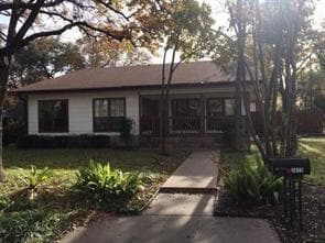
2415 W 10th St
Austin, TX 78703
Today
|
Edit
Favorites
512-705-7038
-
Bedrooms
4
-
Bathrooms
3
-
Square Feet
3,200 sq ft
-
Available
Available Now
Highlights
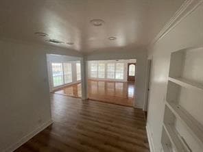
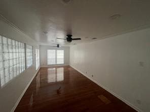
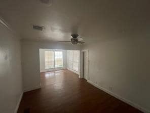
- Wood Flooring
- Tile Flooring
- 1-Story Property
- Central Heating and Cooling System
- North Facing Home
- Privacy Fence
2415 W 10th St

Favorites
About This Home
Available Now
Extraordinary and spacious Home in the Heart of West Austin MLS ID 1590127
2415 W 10th St is a house located in Travis County and the 78703 ZIP Code. This area is served by the Austin Independent School District attendance zone.
* Price shown is base rent. Excludes user-selected optional fees and variable or usage-based fees and required charges due at or prior to move-in or at move-out. Price, availability, fees, and any applicable rent special are subject to change without notice.
* Square footage definitions vary. Displayed square footage is approximate.
Home Details
Home Type
Single Family Detached Home
Year Built
Built in 1947
Bedrooms and Bathrooms
4 Main Level Bedrooms
3 Full Bathrooms
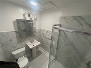
Flooring
Wood
Tile
Interior Spaces
1-Story Property
3,200 Sq Ft Home
Kitchen
Built-In Oven
Gas Cooktop
Dishwasher
Laundry
Laundry in Kitchen
Listing and Financial Details
Security Deposit $4,000
12 Month Lease Term
$100 Application Fee
Assessor Parcel Number 01110701080000
Tenant pays for all utilities
Lot Details
9,365 Sq Ft Lot
North Facing Home
Privacy Fence
Wood Fence
Parking
Off-Street Parking
4 Parking Spaces
Schools
Casis Elementary School
O Henry Middle School
Austin High School
Utilities
Central Heating and Cooling System
Community Details
Overview
No Home Owners Association
Property managed by PSS Services
Marlton Place Sec 01 Subdivision
Pet Policy
Pets allowed on a case-by-case basis
Pet Deposit $500
Contact
- Listed by Charles Kreutz | All City Real Estate Ltd. Co
- Phone Number
- Contact
-
Source
 Austin Board of REALTORS®
The information included in this listing is provided exclusively for consumers’ personal, non-commercial use and may not be used for any purpose other than to identify prospective properties consumers may be interested in purchasing. The information on each listing is furnished by the owner and deemed reliable to the best of his/her knowledge, but should be verified by the purchaser. ABoR, ACTRIS and Estately assume no responsibility for typographical errors, misprints or misinformation. This property listing is offered without respect to any protected classes in accordance with the law. Copyright © 2026.
Location
Get Directions
Following a bend in the Colorado River, Westfield extends from the river north to Enfield Road, following the road until it reaches the Mopac Expressway. The neighborhood contains a stretch of parks from the river northward, including Eilers Park, home to the historic Deep Eddy. A large portion of this small neighborhood is occupied by the Lions Municipal Golf Course, an 18-hole course that opened in 1924.
The historic Stone Windmill, once home to Effie Cara and Wylie Wilson Bennett, is a unique feature in the Johnson Creek Greenbelt, which also features a hiking and biking trail. Westenfield Neighborhood Park, located at the north end of the greenbelt, contains a playground, a swimming pool, and a walkway. If you’re moving to Westfield with a dog, you’ll appreciate having Redbud Isle Park, home to a leash-free dog park, nearby.
While Westfield is primarily residential, there are some great destinations to try. The Hula Hut, located on the river, provides great views of Lake Austin.
Learn more about living in Westfield
Amenities
- Dishwasher
- Refrigerator
- Hardwood Floors
- Tile Floors
Education
| Colleges & Universities | Distance | ||
|---|---|---|---|
| Colleges & Universities | Distance | ||
| Drive: | 5 min | 2.2 mi | |
| Drive: | 8 min | 3.5 mi | |
| Drive: | 13 min | 5.1 mi | |
| Drive: | 11 min | 5.5 mi |
2415 W 10th St is within 5 minutes or 2.2 miles from Austin C.C., Rio Grande Campus. It is also near University of Texas at Austin and Austin C.C., Eastview Campus.
Schools


Public Middle School
Grades 6-8
754 Students
Attendance Zone
Public High School
Grades 9-12
2,317 Students
Attendance Zone
Private Elementary, Middle & High School
Grades K-12
199 Students
Nearby
Private Elementary & Middle School
Grades K-8
151 Students
Nearby
School data provided by
 The GreatSchools Rating helps parents compare schools within a state based on a variety of school quality indicators and provides a helpful picture of how effectively each school serves all of its students. Ratings are on a scale of 1 (below average) to 10 (above average) and can include test scores, college readiness, academic progress, advanced courses, equity, discipline and attendance data. We also advise parents to visit schools, consider other information on school performance and programs, and consider family needs as part of the school selection process.
View GreatSchools Rating Methodology
Data provided by GreatSchools.org © 2026. All rights reserved.
View GreatSchools Rating Methodology
Data provided by GreatSchools.org © 2026. All rights reserved.
Transportation options available in Austin include Downtown Station, located 2.9 miles from 2415 W 10th St. 2415 W 10th St is near Austin-Bergstrom International, located 14.4 miles or 28 minutes away.
| Transit / Subway | Distance | ||
|---|---|---|---|
| Transit / Subway | Distance | ||
| Drive: | 7 min | 2.9 mi | |
| Drive: | 9 min | 4.3 mi | |
| Drive: | 9 min | 4.8 mi | |
| Drive: | 14 min | 6.4 mi | |
| Drive: | 13 min | 7.1 mi |
| Commuter Rail | Distance | ||
|---|---|---|---|
| Commuter Rail | Distance | ||
|
|
Drive: | 6 min | 2.2 mi |
|
|
Drive: | 43 min | 34.4 mi |
|
|
Drive: | 46 min | 37.1 mi |
| Airports | Distance | ||
|---|---|---|---|
| Airports | Distance | ||
|
Austin-Bergstrom International
|
Drive: | 28 min | 14.4 mi |
Getting Around
 What do Walkability, Transit, Drivability, and Bikeability mean?
Walkability measures the walking distance to day-to-day needs.
Transit measures access to public transportation.
Drivability measures congestion, parking availability, and access to major roads.
Bikeability measures the suitability for cycling.
How It Works
What do Walkability, Transit, Drivability, and Bikeability mean?
Walkability measures the walking distance to day-to-day needs.
Transit measures access to public transportation.
Drivability measures congestion, parking availability, and access to major roads.
Bikeability measures the suitability for cycling.
How It Works
Moderately Walkable
Walkability
60
/ 100
Limited Public Transit
Transit
30
/ 100
Moderately Drivable
Drivability
70
/ 100
Moderately Bikeable
Bikeability
70
/ 100
Scores provided by
Active
Soundscore™
74
/ 100
Traffic
ActiveAirport
CalmBusinesses
CalmScores provided by
HowLoud What is a Sound Score Rating? A Sound Score Rating aggregates noise caused by vehicle traffic, airplane traffic and local sources. How It WorksTime and distance from 2415 W 10th St.
| Shopping Centers | Distance | ||
|---|---|---|---|
| Shopping Centers | Distance | ||
| Walk: | 4 min | 0.2 mi | |
| Drive: | 3 min | 1.2 mi | |
| Drive: | 4 min | 1.4 mi |
2415 W 10th St has 3 shopping centers within 1.4 miles, which is about a 4-minute drive. The miles and minutes will be for the farthest away property.
| Parks and Recreation | Distance | ||
|---|---|---|---|
| Parks and Recreation | Distance | ||
|
Red Bud Isle
|
Drive: | 4 min | 1.4 mi |
|
Shoal Creek Greenbelt Park
|
Drive: | 6 min | 2.5 mi |
|
Zilker Botanical Garden
|
Drive: | 6 min | 2.8 mi |
|
Austin Nature and Science Center
|
Drive: | 7 min | 3.4 mi |
|
Zilker Nature Preserve
|
Drive: | 7 min | 3.4 mi |
2415 W 10th St has 5 parks within 3.4 miles, including Austin Nature and Science Center, Zilker Nature Preserve, and Red Bud Isle.
| Hospitals | Distance | ||
|---|---|---|---|
| Hospitals | Distance | ||
| Drive: | 6 min | 2.9 mi | |
| Drive: | 5 min | 3.0 mi | |
| Drive: | 6 min | 3.1 mi |
2415 W 10th St has 3 hospitals within 3.1 miles, the nearest is Dell Seton Medical Center at The University of Texas which is 2.9 miles away and a 6 minute drive.
| Military Bases | Distance | ||
|---|---|---|---|
| Military Bases | Distance | ||
| Drive: | 85 min | 69.4 mi | |
| Drive: | 93 min | 74.8 mi |
2415 W 10th St is 69.4 miles from Randolph Air Force Base, and is convenient to other military bases, including Fort Hood.
You May Also Like
Similar Rentals Nearby
-
-
-
-

-

-

-

-

-

-
 4 Beds$2,615Total Monthly PriceTotal Monthly Price NewPrices include all required monthly fees.House for Rent

What Are Walk Score®, Transit Score®, and Bike Score® Ratings?
Walk Score® measures the walkability of any address. Transit Score® measures access to public transit. Bike Score® measures the bikeability of any address.
What is a Sound Score Rating?
A Sound Score Rating aggregates noise caused by vehicle traffic, airplane traffic and local sources.

2415 W 10th St
Austin, TX 78703