

$1,595
/ Month
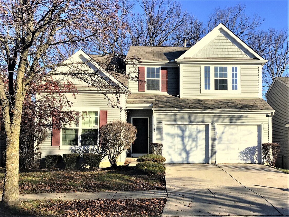
2400 Oaktree Pl
Cincinnati, OH 45238
2 Weeks Ago
Favorites
2400 Oaktree Place

Favorites
Check Back Soon for Upcoming Availability
| Beds | Baths | Average SF |
|---|---|---|
| 3 Bedrooms 3 Bedrooms 3 Br | 2.5 Baths 2.5 Baths 2.5 Ba | 1,975 SF |
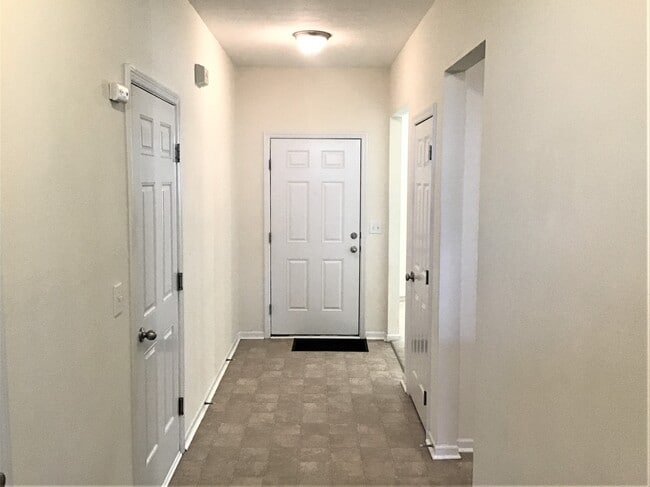
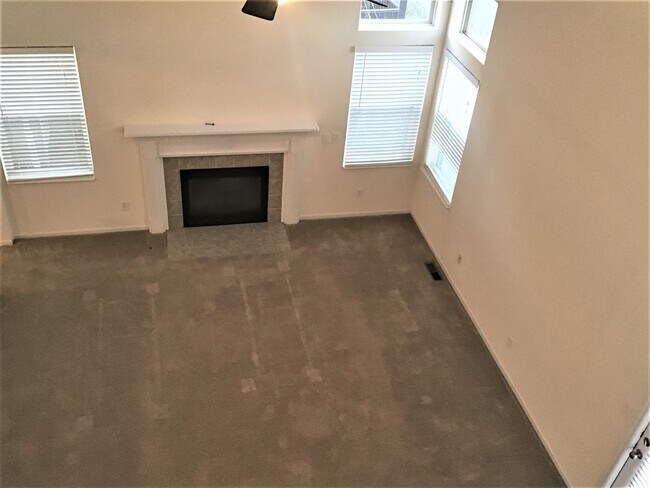
About This Property
This 4 bedroom, 2.5 bath home has 1,975 square feet of living space. Leases signed in this state may be subject to a 9.99 utility fee, local taxes and processing fees. Home details on Landlord’s website are offered for illustrative purposes only. Actual home details may vary. Applicant should verify all information before lease execution. Please contact an American Homes 4 Rent Leasing Consultant for more information.
2400 Oaktree Place is a house located in Hamilton County and the 45238 ZIP Code. This area is served by the Cincinnati Public Schools attendance zone.
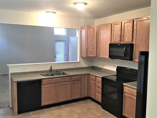
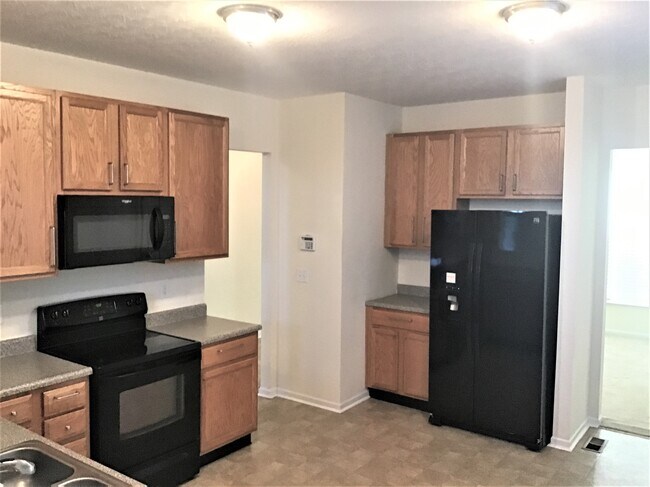
House Features
- Dishwasher
- Microwave
- Refrigerator
Location
Get Directions
Situated about five miles northwest of Downtown Cincinnati, Westwood is the largest neighborhood in the city. Residents flock to Westwood for its many affordable historic homes and modern apartments available for rent in addition to its close proximity to I-74, I-75, and all that Downtown Cincinnati has to offer.
While Westwood is a predominantly residential neighborhood, it is also home to a slew of convenient stores and restaurants. Shopping opportunities abound in Westwood, with plenty of national retailers in Western Hills Plaza and local shops in the growing Town Hall District. Numerous neighborhood parks provide ample space to enjoy the outdoors in town as well as the sprawling 1,400-acre Mount Airy Forest, which is partially located in Westwood.
Learn more about living in WestwoodBelow are rent ranges for similar nearby apartments
Amenities
- Dishwasher
- Microwave
- Refrigerator
Education
| Colleges & Universities | Distance | ||
|---|---|---|---|
| Colleges & Universities | Distance | ||
| Drive: | 13 min | 5.1 mi | |
| Drive: | 14 min | 5.4 mi | |
| Drive: | 13 min | 5.6 mi | |
| Drive: | 14 min | 5.6 mi |
2400 Oaktree Place is within 14 minutes or 5.4 miles from Cincinnati State. It is also near University of Cincinnati and College of Mount St. Joseph.
Schools


Public Elementary School
Grades PK-6
454 Students
Attendance Zone
Public Middle & High School
Grades 7-12
897 Students
Attendance Zone
Public Middle & High School
Grades 6-12
1,418 Students
Attendance Zone
Private Elementary & Middle School
Grades PK-8
381 Students
Nearby
Private Elementary & Middle School
Grades K-8
197 Students
Nearby
Private High School
Grades 9-12
535 Students
Nearby
School data provided by
 The GreatSchools Rating helps parents compare schools within a state based on a variety of school quality indicators and provides a helpful picture of how effectively each school serves all of its students. Ratings are on a scale of 1 (below average) to 10 (above average) and can include test scores, college readiness, academic progress, advanced courses, equity, discipline and attendance data. We also advise parents to visit schools, consider other information on school performance and programs, and consider family needs as part of the school selection process.
View GreatSchools Rating Methodology
Data provided by GreatSchools.org © 2025. All rights reserved.
View GreatSchools Rating Methodology
Data provided by GreatSchools.org © 2025. All rights reserved.
Transportation options available in Cincinnati include Brewery District Station, Elm & Henry, located 4.0 miles from 2400 Oaktree Place. 2400 Oaktree Place is near Cincinnati/Northern Kentucky International, located 18.4 miles or 35 minutes away.
| Transit / Subway | Distance | ||
|---|---|---|---|
| Transit / Subway | Distance | ||
| Drive: | 10 min | 4.0 mi | |
| Drive: | 10 min | 4.3 mi | |
| Drive: | 11 min | 4.3 mi | |
| Drive: | 11 min | 4.4 mi | |
| Drive: | 11 min | 4.6 mi |
| Commuter Rail | Distance | ||
|---|---|---|---|
| Commuter Rail | Distance | ||
|
|
Drive: | 10 min | 4.3 mi |
| Airports | Distance | ||
|---|---|---|---|
| Airports | Distance | ||
|
Cincinnati/Northern Kentucky International
|
Drive: | 35 min | 18.4 mi |
Time and distance from 2400 Oaktree Place.
| Shopping Centers | Distance | ||
|---|---|---|---|
| Shopping Centers | Distance | ||
| Walk: | 17 min | 0.9 mi | |
| Drive: | 5 min | 1.9 mi | |
| Drive: | 5 min | 2.1 mi |
2400 Oaktree Place has 3 shopping centers within 2.1 miles, which is about a 5-minute walk. The miles and minutes will be for the farthest away property.
| Parks and Recreation | Distance | ||
|---|---|---|---|
| Parks and Recreation | Distance | ||
|
Imago Earth Center
|
Drive: | 8 min | 2.9 mi |
|
Wilson Commons
|
Drive: | 10 min | 3.8 mi |
|
Museum of Natural History and Science
|
Drive: | 10 min | 4.3 mi |
|
Cincinnati History Museum
|
Drive: | 10 min | 4.3 mi |
|
Embshoff Woods
|
Drive: | 12 min | 4.5 mi |
2400 Oaktree Place has 5 parks within 4.5 miles, including Imago Earth Center, Wilson Commons, and Museum of Natural History and Science.
| Hospitals | Distance | ||
|---|---|---|---|
| Hospitals | Distance | ||
| Drive: | 13 min | 5.1 mi | |
| Drive: | 12 min | 5.1 mi | |
| Drive: | 13 min | 5.3 mi |
2400 Oaktree Place has 3 hospitals within 5.3 miles, the nearest is Christ Hospital which is 5.1 miles away and a 13 minute drive.
| Military Bases | Distance | ||
|---|---|---|---|
| Military Bases | Distance | ||
| Drive: | 76 min | 56.3 mi | |
| Drive: | 82 min | 61.4 mi | |
| Drive: | 84 min | 64.6 mi |
2400 Oaktree Place has 3 military bases within 64.6 miles, the nearest is Gentile Air Force Station which is 56.3 miles away and a 76 minute drive.
You May Also Like
Similar Rentals Nearby


What Are Walk Score®, Transit Score®, and Bike Score® Ratings?
Walk Score® measures the walkability of any address. Transit Score® measures access to public transit. Bike Score® measures the bikeability of any address.
What is a Sound Score Rating?
A Sound Score Rating aggregates noise caused by vehicle traffic, airplane traffic and local sources
2400 Oaktree Pl
Cincinnati, OH 45238